This item has been sold, but you can get on the Waitlist to be notified if another example becomes available, or purchase a digital scan.
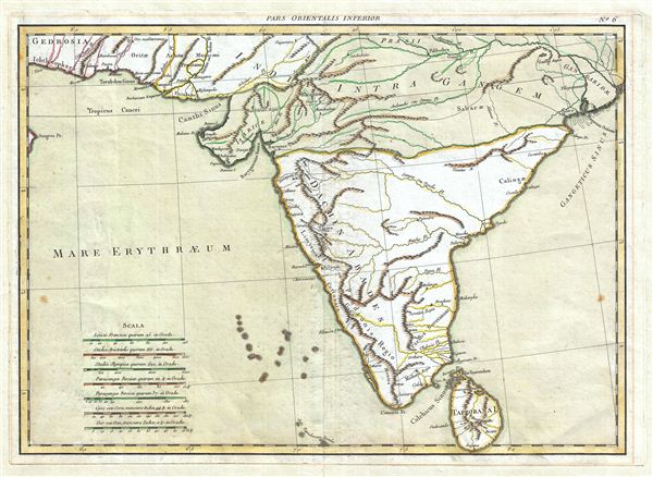
1750 Janvier Map of India in Antiquity
India-janvier-1750$125.00

Title
Pars Orientalis Inferior.
1730 (undated) 13 x 18 in (33.02 x 45.72 cm)
1730 (undated) 13 x 18 in (33.02 x 45.72 cm)
Description
A beautiful map of India in antiquity issued by J. Janvier c. 1750. This map covers the subcontinent from the Indus to the Ganges and as far south as Ceylon (Sri Lanka), which is here identified as Taprobana. Shows various speculative mountain ranges running through central India as well as several early Indian empires citied in various questionable sources dating from antiquity.
Cartographer
Jean Denis Janvier (fl. 1746 - 1776), sometime also known as 'Robert', was a Paris based cartographer active in the mid to late 18th century. Janvier signed his maps Signor Janvier. By the late 18th century, Janvier was awarded the title of 'Geographe Avec Privilege du Roi' and this designation appears on many of his later maps. Janvier worked with many of the most prominent French, English and Italian map publishers of his day, including Longchamps, Faden, Lattre, Bonne, Santini, Zannoni, Delamarche, and Desnos. More by this mapmaker...
Condition
Very Good. Exhibits some edge soiling.
References
Institut Cartogràfic de Catalunya, RM.268915.