1683 Nicolas Sanson Map the Indian Peninsula and Malabar
India-sanson-1683$300.00

Title
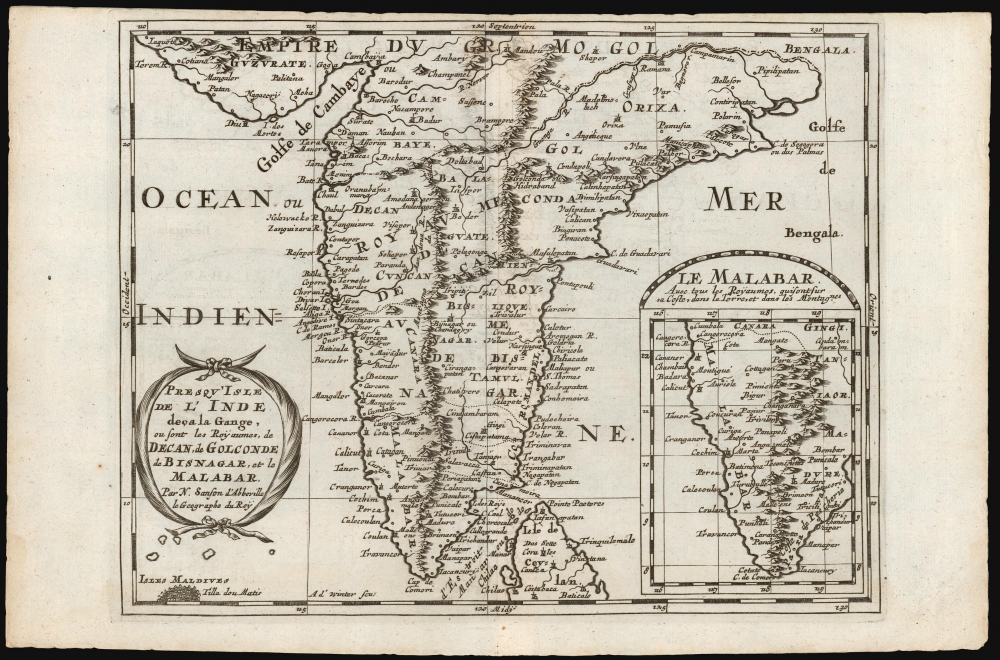
Presqu'Isle de l'Inde deça la Gange, ou sont les Royaumes, de Decan, de Golconde dd Bisnagar, et le Malabar. Par N. Sanson d'Abbeville le Geographe du Roy.
1683 (undated) 7.5 x 9.75 in (19.05 x 24.765 cm) 1 : 9300000
1683 (undated) 7.5 x 9.75 in (19.05 x 24.765 cm) 1 : 9300000
Description
This is Nicolas Sanson's 1653 map of the Indian Peninsula, reengraved for its first Dutch edition of 1683.
A Closer Look
The map extends from Guzarat and the Bay of Bengal in the north to Cape Comorin and the northern part of Sri Lanka in the south. Coverage includes the northernmost atoll of the Maldives, Thiladhummathi (Tilla dou Matis on the map) An inset map in the lower right focuses on the Malabar coast. Sanson provides copious detail throughout, despite European geographer's predominant ignorance of Indian geography away from the coast – particularly with respect to the mountain ranges depicted here. Nevertheless, the major southern regions of the Deccan plateau and the Malabar coast are depicted. The southeastern region is named Bisnagar, a convoluted Europeanization of the Vijayanagara Empire, which, despite being a power in the 16th century, was completely ruined by Sanson's day. The Golconda Sultanate, in the northeast of the map, with its capital at Hyderabad (Hidraband on the map), was a current power. It would last until the Mughal empire conquered the Deccan in 1687.The International Edition
Sanson's small-format atlas, published in four volumes each dedicated to its own continent, had proved popular in Paris. In 1683, an edition collecting all four parts was published by Ribbius in Utrecht. The text was written by historian and exoticist Simon de Vries, and the maps were newly-engraved by Anthonie de Winter. They were faithful and skilled copies of those engraved for Sanson in Paris.Publication History and Census
This map was initially produced in 1653 for inclusion in Sanson's L'Asie En Plusieurs Cartes Nouvelles Et Exactes; Et En Divers Traittés De Geographie et D'Histoire. It was re-engraved in Utrecht for inclusion in the 1683 Geographische en historische beschryvingh der vier bekende werelds-deelen Europa, Asia, Africa en America, published by Ribbius. The present example corresponds with this first, 1683 state of the map. In 1700, when the maps were republished in Amsterdam by François Halma, the plate would be reworked, with more boldly engraved borders. The atlas is well represented in institutional collections. The separate map is not listed in OCLC with reference to the Utrecht edition, but it is abundantly possible that some of the many examples listed as Paris or Amsterdam printings are misidentified.CartographerS
Nicolas Sanson (December 20, 1600 - July 7, 1667) and his descendants were the most influential French cartographers of the 17th century and laid the groundwork for the Golden Age of French Cartography. Sanson was born in Picardy, but his family was of Scottish Descent. He studied with the Jesuit Fathers at Amiens. Sanson started his career as a historian where, it is said, he turned to cartography as a way to illustrate his historical studies. In the course of his research some of his fine maps came to the attention of King Louis XIII who, admiring the quality of his work, appointed Sanson Geographe Ordinaire du Roi. Sanson's duties in this coveted position included advising the king on matters of geography and compiling the royal cartographic archive. In 1644, he partnered with Pierre Mariette, an established print dealer and engraver, whose business savvy and ready capital enabled Sanson to publish an enormous quantity of maps. Sanson's corpus of some three hundred maps initiated the golden age of French mapmaking and he is considered the 'Father of French Cartography.' His work is distinguished as being the first of the 'Positivist Cartographers,' a primarily French school of cartography that valued scientific observation over historical cartographic conventions. The practice result of the is less embellishment of geographical imagery, as was common in the Dutch Golden Age maps of the 16th century, in favor of conventionalized cartographic representational modes. Sanson is most admired for his construction of the magnificent atlas Cartes Generales de Toutes les Parties du Monde. Sanson's maps of North America, Amerique Septentrionale (1650), Le Nouveau Mexique et La Floride (1656), and La Canada ou Nouvelle France (1656) are exceptionally notable for their important contributions to the cartographic perceptions of the New World. Both maps utilize the discoveries of important French missionaries and are among the first published maps to show the Great Lakes in recognizable form. Sanson was also an active proponent of the insular California theory, wherein it was speculated that California was an island rather than a peninsula. After his death, Sanson's maps were frequently republished, without updates, by his sons, Guillaume (1633 - 1703) and Adrien Sanson (1639 - 1718). Even so, Sanson's true cartographic legacy as a 'positivist geographer' was carried on by others, including Alexis-Hubert Jaillot, Guillaume De L'Isle, Gilles Robert de Vaugondy, and Pierre Duval. More by this mapmaker...
Anthonie de Winter (1653-1707) was a Dutch engraver, etcher, publisher and art dealer. Son of Hendrik de Winter, a seal-engraver and silversmith. Little is known of his education, but it probably involved an apprenticeship to his father prior to his being made a member of the guild of St. Luke in Amsterdam, later joining the guild of booksellers as an engraver. He engraved maps for Nicolas Sanson in 1683, Jacob Lootsman in 1696, and contributed to the Vries Zee Atlas in 1698. He also engraved playing cards with Carel de Waganaer. Learn More...
Simon de Vries (1624 - 1708) was a Dutch poet, writer, historian, bookseller, publisher, and translator. De Vries had a keen eye for his readership's hunger for geographical information, and was pleased to provide it. He has been derided as a hack by later historians, mainly for the common practice of producing copious histories and travel works without having ever visited the places about which he wrote. He produced a number of books for the Utrecht publisher Ribbius, including the text for the 1683 Dutch edition of his atlas, Geographische en historische beschryvingh. Learn More...
Source
Sanson, N. / Vries, Simon de, Geographische en historische beschryvingh der vier bekende werelds-deelen Europa, Asia, Africa en America, (Utrecht: Ribbius) 1683.
Condition
Very good. Top margin close, but borders complete. Else excellent.
References
OCLC 956307608 (1700 Halma). Gole, S. Early Maps of India #15 (Paris edition, misdated 1652).