This item has been sold, but you can get on the Waitlist to be notified if another example becomes available, or purchase a digital scan.
1838 Wyld Wall Map of India (Hindostan or British India)
India-wyld-1838$300.00

Title
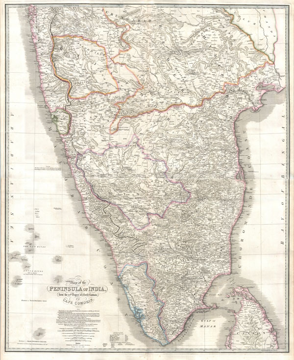
Map of the Peninsula of India, from the 19th. Degree of North Latitude, to Cape Cormorin.
1838 (dated) 40 x 33 in (101.6 x 83.82 cm)
1838 (dated) 40 x 33 in (101.6 x 83.82 cm)
Description
This stunning wall map of India, dating to 1838 is James Wyld's reissued of William Faden's important c. 1799 map of the same region. This is one of the largest and most impressive maps of India to emerge in the 19th century. This chart depicts the subcontinent from Bombay ( Mumbai ) and Aurangabad, south including the northern half of Sri Lanka (Ceylon). Though largely based on the 18th century mapmaking work of James Rennell, Wyld has significantly updated the Faden's cartographic representation of India by incorporating the survey work of Sir Archibald Campbell, Col. Kelly, Captain Pringle, and Colonel Allen. Consequently the issue of this important map marks a significant advancement in the 18th century perspective of India. The subcontinent is now crisscrossed with a broad network of roadways and significant interior detail has been added throughout. Here and there on the map are notes regarding the dates and battles related to the British conquest of India in the 18th century - these as well as the overall structure of the map have been retained from the original Faden map.
Cartographer
Wyld (1823 - 1893) was a British publishing firm active throughout the 19th century. It was operated by James Wyld I (1790 - 1836) and his son James Wyld II (November 20, 1812 - 1887) were the principles of an English mapmaking dynasty active in London during much of the 19th century. The elder Wyld was a map publisher under William Faden (1749 - 1836) and did considerable work on the Ordinance Survey. On Faden's retirement in 1823, Wyld took over Faden's workshop, acquiring many of his plates. Wyld's work can often be distinguished from his son's maps through his imprint, which he signed as 'Successor to Faden'. Following in his father's footsteps, the younger Wyld joined the Royal Geographical Society in 1830 at the tender age of 18. When his father died in 1836, James Wyld II was prepared to fully take over and expand his father's considerable cartographic enterprise. Like his father and Faden, Wyld II held the title of official Geographer to the Crown, in this case, Queen Victoria. In 1852, he moved operations from William Faden's old office at Charing Cross East (1837 - 1852) to a new, larger space at 475 Strand. Wyld II also chose to remove Faden's name from all of his updated map plates. Wyld II continued to update and republish both his father's work and the work of William Faden well into the late 1880s. One of Wyld's most eccentric and notable achievements is his 1851 construction of a globe 19 meters (60 feet) in diameter in the heart of Leicester Square, London. In the 1840s, Wyld also embarked upon a political career, being elected to parliament in 1847 and again in 1857. He died in 1887 following a prolific and distinguished career. After Wyld II's death, the family business was briefly taken over by James John Cooper Wyld (1844 - 1907), his son, who ran it from 1887 to 1893 before selling the business to Edward Stanford. All three Wylds are notable for producing, in addition to their atlas maps, short-run maps expounding upon important historical events - illustrating history as it was happening - among them are maps related to the California Gold Rush, the New South Wales Gold Rush, the Scramble for Africa, the Oregon Question, and more. More by this mapmaker...
Source
Wyld, J., A new general atlas of modern geography consisting of a complete collection of maps of the four quarters of the globe delineating their physical features and coloured to show the limits of their respective states : including also the latest geographical and nautical discoveries, c. 1838.
Condition
Very good. Professionally flattened. Two sheets joined.