This item has been sold, but you can get on the Waitlist to be notified if another example becomes available, or purchase a digital scan.
1840 Wyld Map of India and Afghanistan
India-wyld-1840$500.00

Title
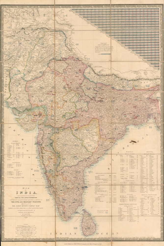
Map of India, Constructed with great care and research from all the latest authorities and intended more particularly to facilitate a reference to the Civil and Military Stations.
1840 (dated) 37.5 x 26 in (95.25 x 66.04 cm) 1 : 4000000
1840 (dated) 37.5 x 26 in (95.25 x 66.04 cm) 1 : 4000000
Description
This is the 1840 edition of James Wyld's map of India. The map reveals the subcontinent at the height of the British East India Company hegemony and in the initial periods of the 'Great Game'.
A Closer Look
The map's superb detail reflects the extent of British East India's control over the vast country, and the great difficulty posed in trying to comprehend the scope of that control. It was clearly intended as an administrative tool to that end, but also to be of utility to British travelers working with the EIC or civil service, and Britisher at home interested in affairs abroad. The map's rich detail is made legible by the imposition of a numbered coordinate grid cross-referenced to lists of military and civil stations in Madras and Bengal as well as 'Collectorates,' the main tax designations employed by the EIC. Military administration is indicated, marking stations of the Bengal Army, Bombay Army, and Madras Army, distinguished from one another with hand color. All three of these armies represented British military power, via the three 'Presidencies' of Bengal, Bombay, and Madras. The armies themselves belonged to the East India Company, until the Government of India Act of 1858, which transferred governance to the Crown. The map itself is superbly executed, largely thanks to the unprecedented scientific precision of the Great Trigonometric Survey of India.The Great Game
'The Great Game' was a diplomatic confrontation between the British and Russian Empires over Afghanistan and other territories in Central and Southern Asia. The conflict, rooted in long-standing animosity between Russia and Britain, revolved around Afghanistan, which, while lacking significant resources of its own, was strategically situated. For its part, Russia feared Britain was making commercial and military inroads into Central Asia, an area long within the sphere of influence of St. Petersburg. Britain, conversely, feared Russia making gains in India, 'the jewel in the crown' of British Asia. The escalating tensions led to several wars and proxy wars: The First Anglo-Afghan War (1839 - 1842), the First Anglo-Sikh War (1845 - 1846), the Second Anglo-Sikh War (1848 - 1849), and the Second Anglo-Afghan War (1878 - 1880), along with the Russian annexations of Khiva, Bukhara, and Kokand. Then as now, Afghanistan proved a grinding stone upon which the world's great empires diminished themselves, none achieving a definitive victory despite committing staggering resources. The Great Game 'ended' on September 10, 1895 with the signing of the Pamir Boundary Commission Protocols, which stabilized the border between Afghanistan and the Russian Empire - but well into the 20th century the British were well aware the conflict remained. Regarding the attitude of Afghans to the British and to the Russians, the general assumption of the British was that 'Some will fight for us, some against us, but all will fight.'Publication History and Census
This map was first published in 1837 and stayed in publication for the rest of the century. The initial publication of the map in 1837 pre-dates, by a year, the First Anglo-Afghan War (1838 - 1842), the theater of which falls entirely within its scope. The map was likely initially inspired by Lord Palmerston and John Hobhouse's warnings of a possible Russian invasion of British India through Afghanistan, threatening the EIC's interests in India. The onset of the Anglo-Afghan war in 1839 would have only sharpened public demand. This example, printed and dated 1840, is among the earliest obtainable. OCLC shows only the 1837 issue predating the 1840; only two examples of this state appear, one at Harvard and the other at the University of Edinburgh. 1842 issues appear to be more common due to public demand for up-to-date information about the First Anglo-Afghan War (1838 - 1842).Cartographer
Wyld (1823 - 1893) was a British publishing firm active throughout the 19th century. It was operated by James Wyld I (1790 - 1836) and his son James Wyld II (November 20, 1812 - 1887) were the principles of an English mapmaking dynasty active in London during much of the 19th century. The elder Wyld was a map publisher under William Faden (1749 - 1836) and did considerable work on the Ordinance Survey. On Faden's retirement in 1823, Wyld took over Faden's workshop, acquiring many of his plates. Wyld's work can often be distinguished from his son's maps through his imprint, which he signed as 'Successor to Faden'. Following in his father's footsteps, the younger Wyld joined the Royal Geographical Society in 1830 at the tender age of 18. When his father died in 1836, James Wyld II was prepared to fully take over and expand his father's considerable cartographic enterprise. Like his father and Faden, Wyld II held the title of official Geographer to the Crown, in this case, Queen Victoria. In 1852, he moved operations from William Faden's old office at Charing Cross East (1837 - 1852) to a new, larger space at 475 Strand. Wyld II also chose to remove Faden's name from all of his updated map plates. Wyld II continued to update and republish both his father's work and the work of William Faden well into the late 1880s. One of Wyld's most eccentric and notable achievements is his 1851 construction of a globe 19 meters (60 feet) in diameter in the heart of Leicester Square, London. In the 1840s, Wyld also embarked upon a political career, being elected to parliament in 1847 and again in 1857. He died in 1887 following a prolific and distinguished career. After Wyld II's death, the family business was briefly taken over by James John Cooper Wyld (1844 - 1907), his son, who ran it from 1887 to 1893 before selling the business to Edward Stanford. All three Wylds are notable for producing, in addition to their atlas maps, short-run maps expounding upon important historical events - illustrating history as it was happening - among them are maps related to the California Gold Rush, the New South Wales Gold Rush, the Scramble for Africa, the Oregon Question, and more. More by this mapmaker...
Condition
Very good. Dissected and mounted on linen for folding, as issued. Original slipcase present and in sound condition.
References
OCLC 673203526.