This item has been sold, but you can get on the Waitlist to be notified if another example becomes available, or purchase a digital scan.
1857 Read's Bird's Eye View Map of India
IndiaBirdsEyeView-read-1857$1,000.00

Title
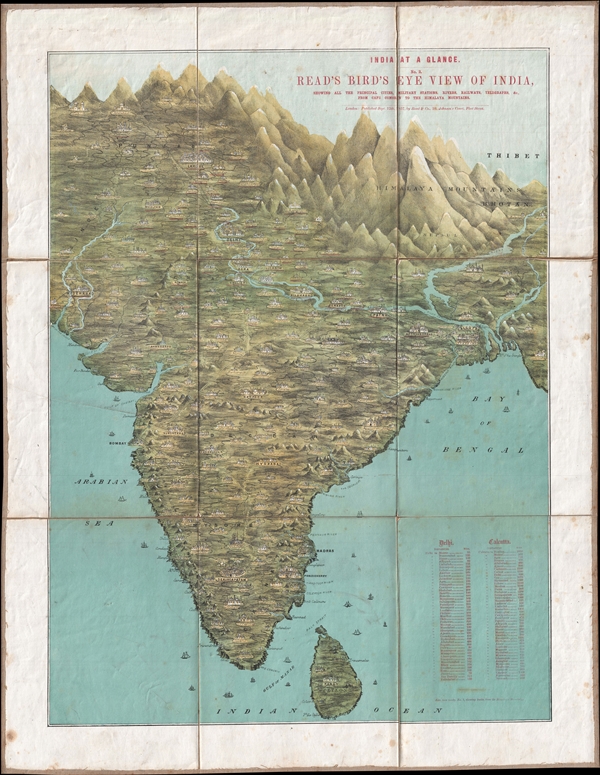
India at a Glance. No. 2. Read's Birds' Eye View of India, showing all the principal cities, Military Stations, Rivers, Railways, Telegraphs, &C. From Cape Comorin to the Himalaya Mountains.
1857 (dated) 28.75 x 22 in (73.025 x 55.88 cm)
1857 (dated) 28.75 x 22 in (73.025 x 55.88 cm)
Description
A map of the utmost rarity, this is Mary Read's 1857 chromolithograph bird's eye view of India. The view presents the subcontinent as it might be seen from somewhere high above the Indian ocean just south of Sri Lanka. The map covers from the Himalayas south to include all of peninsular India as well as the island of Sri Lanka or Ceylon. From east to west it extends from Hyderabad to Mouths of the Ganges. Mountains and cities are drawn in profile. A table showing distances form Delhi in one column and Calcutta in another appears in the lower right.
Mary Read issued this map in 1857 to capitalize on general interest in India associated with the Indian Rebellion (1857 – 1858) or First War of Indian Independence. As the title suggests, this is view no. 2 of a set, the other, though not offered here, was another view of India looking south from the Himalayas. Together they were market as India at a Glance. Today this view is exceedingly rare with only one other example known example housed in the British Library.
Mary Read issued this map in 1857 to capitalize on general interest in India associated with the Indian Rebellion (1857 – 1858) or First War of Indian Independence. As the title suggests, this is view no. 2 of a set, the other, though not offered here, was another view of India looking south from the Himalayas. Together they were market as India at a Glance. Today this view is exceedingly rare with only one other example known example housed in the British Library.
Cartographer
Mary Read (fl. c. 1850 – 1865) was a British lithographer and publisher of illustrated children's books, general interest books, prints, and views active in London during the middle part of the 19th century. Read had the distinction of being one of the few independent female publisher's active in the 19th century. To our knowledge she issued by three birds-eye views and no maps. These include two views of India, and one of the eastern part of the United States during the Civil War. Little else is know of the woman or the firm. Her firm was based at 10 Johnson Court, Fleet Street, London. More by this mapmaker...
Source
Read, M., India at a Glance (London: Read and Co.) 1857.
Condition
Very good. Minor spotting upper margins and lower left margin. Minor toning on original fold lines. Dissected into 9 sections and mounted on linen. Old linen backing soiled but strong.
References
OCLC 557741683.