This item has been sold, but you can get on the Waitlist to be notified if another example becomes available, or purchase a digital scan.
1846 Bradford Map of Indiana
Indiana-bradford-1846$175.00

Title
Indiana.
1846 (dated) 15 x 12 in (38.1 x 30.48 cm) 1 : 1267200
1846 (dated) 15 x 12 in (38.1 x 30.48 cm) 1 : 1267200
Description
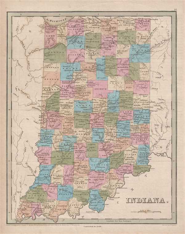
This is an 1846 Thomas G. Bradford map of Indiana. The map depicts the region from Illinois to Ohio and from Michigan and Lake Michigan to Kentucky. Highly detailed, each county is labeled and shaded a different color for easy differentiation. Numerous cities and towns are labeled, including Evansville, South Bend, Peru, Fort Wayne, and Indianapolis. Several railroads are illustrated, along with an extensive canal system, including the Wabash and Erie Canal.
The Wabash and Erie Canal
Extending from the banks of Lake Erie and Toledo, Ohio over 468 miles to Evansville, Indiana, on the Ohio River, the Wabash and Erie Canal was the longest fabricated structure in the United States and became part of the second-longest canal in the world. Construction of the Wabash and Erie Canal on February 22, 1832, with its grand opening celebrated on July 4, 1843. Due to Indiana's unique topography, engineering innovations were required to successfully complete the project, including swing bridges, systems of counterweights, tumbles, damns, locks, and the development of a concrete that would harden beneath water. A dam was built between 1838 and 1841along the Wabash River in Carrol County. A few local citizen blamed the dam for flooding in the area, took care of the 'problem' themselves by dynamiting the dam on February 9, 1881, destroying the canal boat river crossing, and ending Pittsburg, Indiana's economic boom. The Canal provided an economic boom all along its route, with taverns and other establishments springing up along its banks. Several other canals are also illustrated, including the incredible Indiana Central Canal, which was intended to connect the Wabash and Erie Canal to the Ohio River. Due to the Panic of 1837, however, the state of Indiana suffered financially and had to turn over the canal to its creditors, who stopped construction in 1839.
This map was engraved by George Boynton and published in the 1846 edition of Bradford and Goodrich's A Universal Illustrated Atlas.
CartographerS
Thomas Gamaliel Bradford (1802 - 1887) was born in Boston, Massachusetts, where he worked as an assistant editor for the Encyclopedia Americana. Bradford's first major cartographic work was his revision and subsequent republishing of an important French geography by Adrian Balbi, Abrege de Geographie published in America as Atlas Designed to Illustrate the Abridgment of Universal Geography, Modern and Ancient. Afterwards Bradford revised and expanded this work into his own important contributions to American cartography, the 1838 An Illustrated Atlas Geographical, Statistical and Historical of the United States and Adjacent Countries. Bradford's cartographic work is significant as among the first to record Texas as an independent nation. In his long career as a map publisher Bradford worked with William Davis Ticknor of Boston, Freeman Hunt of New York, Charles De Silver of Philadelphia, John Hinton, George Washington Boynton, and others. We have been able to discover little of Bradford's personal life. More by this mapmaker...
George Washington Boynton (fl. c. 1830 - 1850) was a Boston based cartographer and map engraver active in the first half of the 19th century. Boynton engraved and compiled maps for numerous publishers including Thomas Bradford, Nathaniel Dearborn, Daniel Adams, and S. G. Goodrich. His most significant work is most likely his engraving of various maps for Bradford's Illustrated Atlas, Geographical, Statistical, and Historical, of the United States and the Adjacent Countries and Universal Illustrated Atlas. He also engraved for the Boston Almanac. In 1835, Boynton is listed as an employee of the Boston Bewick Company, an engraving, stereotype, and printing concern based at no. 47 Court Street, Boston. Little else is known of his life. Learn More...
Source
Bradford, T. G. and Goodrich, S. G., A Universal Illustrated Atlas, exhibiting a Geographical, Statistical, and Historical view of the World, (Boston: Charles D. Strong) 1846.
The Universal Illustrated Atlas is one of the great American atlases of the first half of the 19th century. The atlas was first published in 1838 under the imprint of Charles D. Strong. It replaced and superseded Bradford's earlier smaller format Illustrated Atlas, Geographical, Statistical, and Historical, of the United States and the Adjacent Countries. Numerous reissues of the Universal Illustrated Atlas followed until about 1848. Although there are minor variations between the editions, most contain about 50 maps, the majority of which focus on the United States. Bradford's atlases are significant for recording North America during the Republic of Texas Era. In later editions, particularly the 1846 edition, Bradford illustrates the boom in railroad construction, possibly with the idea that his maps would aid travelers in planning journeys by rail. It was compiled by Thomas Gamaliel Bradford and Samuel Griswold Goodrich with most of the plates engraved by George Washington Boynton (fl. c. 1830 - 1850). Other contributors include Thomas Gordon (1778 - 1848), Fielding Lucas Jr. (1781 - 1854), Samuel Edward Stiles (1844 - 1901), Sherman and Smith (fl. c. 1829 - 1855), and Horace Thayer (1811 - c. 1874).
Condition
Very good. Even overall toning. Light foxing. Blank on verso.
References
Rumsey 0089.019 (1838 edition).