This item has been sold, but you can get on the Waitlist to be notified if another example becomes available, or purchase a digital scan.
1846 Bradford Map of Indiana
Indiana-bradford-1846-2$175.00

Title
Indiana.
1846 (dated) 14.5 x 11.25 in (36.83 x 28.575 cm) 1 : 1267200
1846 (dated) 14.5 x 11.25 in (36.83 x 28.575 cm) 1 : 1267200
Description
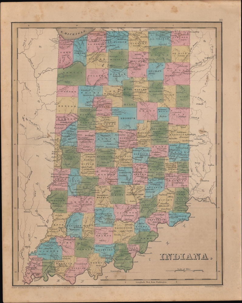
An example of Thomas Bradford's 1846 map of Indiana, published in his Universal Illustrated Atlas.
Not everyone was a fan. Some blamed a dam built between 1838 and 1841 along the Wabash River in Carrol County for regional flooding. Angry locals dynamited the dam on February 9, 1881, destroying the canal boat river crossing and ending Pittsburg, Indiana's economic boom.
Some Potawatomi and Miami secured exemptions from removal based on earlier treaties, while others successfully lobbied the government to return to Indiana after being relocated. However, the 'Reserve' that appears here below Miami County was already anachronistic; it ceased to exist in 1840 with the Treaty of the Wabash to be replaced by Howard and Tipton Counties.
A Closer Look
The map details Indiana, with cities and towns labeled along with geographic features. Though not named, several railroads are illustrated. The state's first rail line, connecting Madison on the Ohio River with Queensville (near Vernon), here reaches Indianapolis, although that portion of the railway was not completed until 1847. In addition to railroads, the state's extensive canal system, including the Wabash and Erie Canal, is illustrated.The Wabash and Erie Canal
Extending from the banks of Lake Erie and Toledo, Ohio, over 468 miles to Evansville, Indiana, on the Ohio River, the Wabash and Erie Canal was at the time of its completion the longest fabricated structure in the United States. Construction of the Wabash and Erie Canal began in 1832, with its grand opening on July 4, 1843. Due to Indiana's unique topography, the work necessitated engineering innovations, including swing bridges, systems of counterweights, tumbles, dams, locks, and the development of concrete that could harden under water. The completion of the canal precipitated an economic boom along its route.Not everyone was a fan. Some blamed a dam built between 1838 and 1841 along the Wabash River in Carrol County for regional flooding. Angry locals dynamited the dam on February 9, 1881, destroying the canal boat river crossing and ending Pittsburg, Indiana's economic boom.
The Last Indians in Indiana
Compared to the earliest edition of Bradford's Indiana, published in 1835 ('Ohio and Indiana,' previously sold by us), the lands of the Potawatomi and Miami Indians in the northern part of the state have here been replaced by counties. Beginning in the 1830s, the Potawatomi, Miami, and other indigenous peoples were relocated, by treaty and force, west of the Mississippi, with most of the Miami being forcibly removed by the military in October 1846.Some Potawatomi and Miami secured exemptions from removal based on earlier treaties, while others successfully lobbied the government to return to Indiana after being relocated. However, the 'Reserve' that appears here below Miami County was already anachronistic; it ceased to exist in 1840 with the Treaty of the Wabash to be replaced by Howard and Tipton Counties.
Publication History and Census
This map was engraved by George Washington Boynton and, despite the date of the copyright at bottom-left, was published in the 1846 edition of Bradford and Goodrich's A Universal Illustrated Atlas.CartographerS
Thomas Gamaliel Bradford (1802 - 1887) was born in Boston, Massachusetts, where he worked as an assistant editor for the Encyclopedia Americana. Bradford's first major cartographic work was his revision and subsequent republishing of an important French geography by Adrian Balbi, Abrege de Geographie published in America as Atlas Designed to Illustrate the Abridgment of Universal Geography, Modern and Ancient. Afterwards Bradford revised and expanded this work into his own important contributions to American cartography, the 1838 An Illustrated Atlas Geographical, Statistical and Historical of the United States and Adjacent Countries. Bradford's cartographic work is significant as among the first to record Texas as an independent nation. In his long career as a map publisher Bradford worked with William Davis Ticknor of Boston, Freeman Hunt of New York, Charles De Silver of Philadelphia, John Hinton, George Washington Boynton, and others. We have been able to discover little of Bradford's personal life. More by this mapmaker...
George Washington Boynton (fl. c. 1830 - 1850) was a Boston based cartographer and map engraver active in the first half of the 19th century. Boynton engraved and compiled maps for numerous publishers including Thomas Bradford, Nathaniel Dearborn, Daniel Adams, and S. G. Goodrich. His most significant work is most likely his engraving of various maps for Bradford's Illustrated Atlas, Geographical, Statistical, and Historical, of the United States and the Adjacent Countries and Universal Illustrated Atlas. He also engraved for the Boston Almanac. In 1835, Boynton is listed as an employee of the Boston Bewick Company, an engraving, stereotype, and printing concern based at no. 47 Court Street, Boston. Little else is known of his life. Learn More...
Source
Bradford, T. G. and Goodrich, S. G., A Universal Illustrated Atlas, exhibiting a Geographical, Statistical, and Historical view of the World, (Boston: Charles D. Strong) 1846.
The Universal Illustrated Atlas is one of the great American atlases of the first half of the 19th century. The atlas was first published in 1838 under the imprint of Charles D. Strong. It replaced and superseded Bradford's earlier smaller format Illustrated Atlas, Geographical, Statistical, and Historical, of the United States and the Adjacent Countries. Numerous reissues of the Universal Illustrated Atlas followed until about 1848. Although there are minor variations between the editions, most contain about 50 maps, the majority of which focus on the United States. Bradford's atlases are significant for recording North America during the Republic of Texas Era. In later editions, particularly the 1846 edition, Bradford illustrates the boom in railroad construction, possibly with the idea that his maps would aid travelers in planning journeys by rail. It was compiled by Thomas Gamaliel Bradford and Samuel Griswold Goodrich with most of the plates engraved by George Washington Boynton (fl. c. 1830 - 1850). Other contributors include Thomas Gordon (1778 - 1848), Fielding Lucas Jr. (1781 - 1854), Samuel Edward Stiles (1844 - 1901), Sherman and Smith (fl. c. 1829 - 1855), and Horace Thayer (1811 - c. 1874).
Condition
Good. Light foxing and soiling.
References
Rumsey 0089.019 (1838 edition).