This item has been sold, but you can get on the Waitlist to be notified if another example becomes available, or purchase a digital scan.
1885 Atkins Map of the United States Indian Reservations
IndianReservations-atkins-1885$250.00


Title
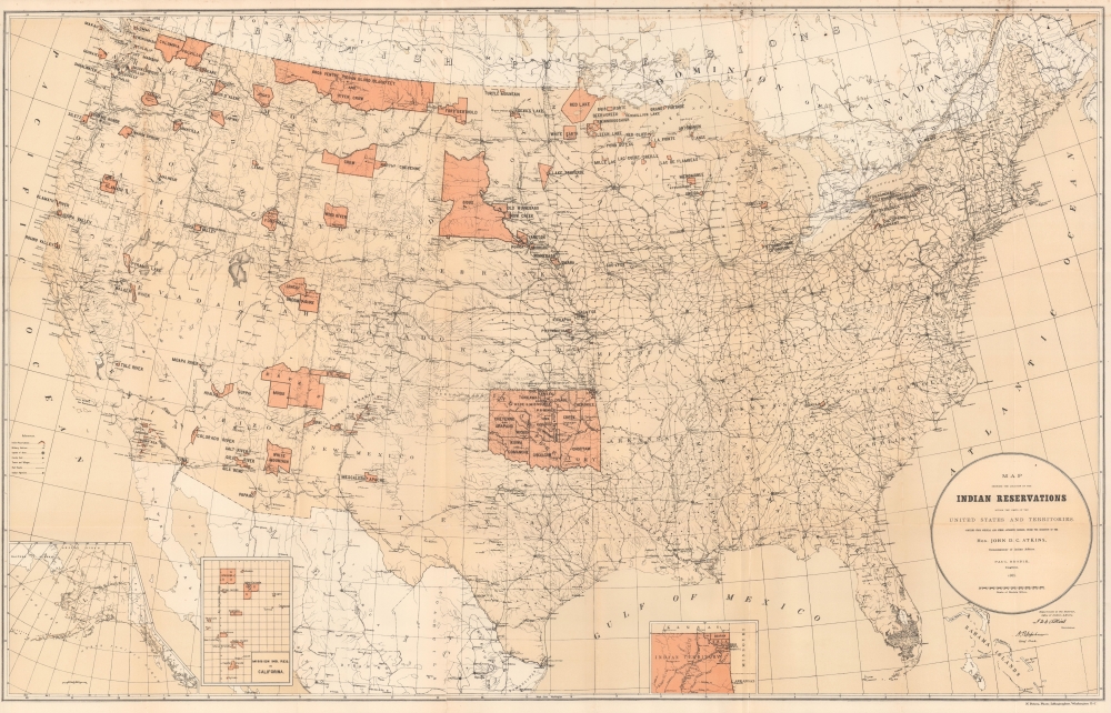
Map Showing Indian Reservations within the Limits of the United States.
1885 (dated) 21 x 33.25 in (53.34 x 84.455 cm) 1 : 5780000
1885 (dated) 21 x 33.25 in (53.34 x 84.455 cm) 1 : 5780000
Description
An impressive 1885 map of the United States highlighting the location of Indian reservations, produced during the tenure of John DeWitt Clinton Atkins as Commissioner of Indian Affairs.
Cities and towns are indicated, as are railroads, military outposts, and Indian Agencies. Three insets are situated along the bottom border that illustrate Alaska, the Mission Indian Reservations in California, and the northeastern corner of the Indian Territory.
A Closer Look
Indian reservations throughout are highlighted in orange and labeled in block lettering. Aside from the large Indian Territory (future Oklahoma), several other reservations loom especially large, including the Sioux Reservation, taking up much of today's South Dakota. Large portions of Montana are divided among the Gros Ventre, Piegan, Blood, Blackfeet, and Crow, and the Navajo and White Mountain Reservations take up significant amounts of land in the Southwest. Many of the reservations seen here were later reduced or eliminated altogether.Cities and towns are indicated, as are railroads, military outposts, and Indian Agencies. Three insets are situated along the bottom border that illustrate Alaska, the Mission Indian Reservations in California, and the northeastern corner of the Indian Territory.
Indian Territory
This map predates the division of the Oklahoma Territory and Indian Territory, and the subsequent elimination of the latter. The concept of an Indian Territory was the successor to the British Indian Reserve, which was established by the Royal Proclamation of 1763. After the Louisiana Purchase, President Jefferson and his successors viewed land west of the Mississippi River as available for the resettlement of Native Americans, which became official policy after the 1830 Indian Removal Act was signed by President Andrew Jackson. The Indian Territory was slowly whittled down as Americans moved west and more and more territories were formed. Wisconsin, Iowa, and the Dakotas all chipped away at land that had once belonged to Native Americans. The borders of modern-day Oklahoma, to which Indian Territory was eventually reduced, were established by the Kansas-Nebraska Act of 1854. In 1890, the Oklahoma Organic Act created the Oklahoma Territory from the western half of the Indian Territory and opened the door for land runs on reservation land.Native Americans in the Late 19th Century
By the time this map was produced, Native Americans faced immense odds in trying to maintain their traditional culture. The armed resistance of earlier decades was no longer a viable option and established migration patterns and lifeways were made impossible. The Grant Administration (1869 - 1877) saw peace overtures along with better oversight of the often-unscrupulous Indian Agents and other exploitative profiteers on the frontier as viable options. But Grant and subsequent presidents saw cultural assimilation as the best means of preserving peace, which led to boarding schools being established and run by Christian missionaries (who were deputized as Indian Agents) on reservations throughout the country. Nomadic peoples were sedentarized, indigenous languages and religious practice were banned in boarding schools (a contribution of Atkins during his tenure as Commissioner of Indian Affairs), and collective landholdings broken up into private plots to promote cultural assimilation.Publication History and Census
This map was drafted by Paul Brodie, under the direction of John D. C. Atkins, the Commissioner of Indian Affairs, and was printed (photo-lithographed) by Norris Peters in Washington, D.C. It appeared in the 'Seventeenth annual report of the Board of Indian Commissioners' (Ex. doc. United States. Congress. House, 49th Congress, 1st session, no. 109, 109 49 1), which was published in 1886 by the Government Printing Office. Multiple editions of the map exist (including examples from 1892 and 1896 previously sold by us), which were generally published in annual reports on Indian affairs, and which can be compared to trace the evolution of reservation lands in the U.S. over time. The present edition is listing among the holdings of about thirty institutions in the OCLC.CartographerS
John DeWitt Clinton Atkins (June 4, 1825 - June 2, 1908) was a politician and government official in both the United States of America and Confederate States of America. He was born and spent much of his life in Henry County, Tennessee. After studying law, he tried his hand at farming before turning to politics, being elected to the Tennessee House of Representatives in 1849 and then the U.S. House of Representatives in 1857. He served in the Confederate Army and was a representative in the Confederate Congress. After the Civil War, he returned to the U.S. House of Representatives in 1873 and would spend the following decade there, becoming a leading opponent of Reconstruction policies. In 1885, he was appointed Commissioner of Indian Affairs, a post he held for three years. More by this mapmaker...
Norris Peters (c. 1834 – July 15, 1889) was a Washington D.C. based photo-lithographer active in the late 18th and early 19th century whom Scientific American called 'one of Washington's most eccentric and mysterious figures.' Peters was born and educated in Pennsylvania. He relocated as a young man to Washington D.C. where he took work as an examiner for the United States Patent Office. During his work with the patent office he became fascinated with the emergent process of photolithography. In 1869 Peters secured substantial venture capital of about 100,000 USD from an unknown investor and founded The Norris Peters Company at 458 Pennsylvania Avenue. Their printing offices have been described as 'unequaled in this or any other country.' From these offices Peters pioneered the development of American photo-lithography. For nearly a generation he held a near monopoly on government photo-lithographic printing. Among their more notable contracts included numerous maps for congressional reports, maps of the U.S. Coast Survey, maps of the U.S. Geological Survey, Mexican currency for the State of Chihuahua, and the Official Gazette of the Patent Office. Peters also maintained an interesting social life and was a confidant to many of the most powerful figures in Congress. He was also a bon vivant known for being an excellent cook and hosting lavish dinners, the invitations to which were 'never declined'. Despite being socially active he never married and died a confirmed bachelor. Following Peters' death in 1889 his business was taken over by Henry Van Arsdale Parsell who administered it until his own death in 1901. The company then merged with Webb & Borcorselski, another D.C. lithography firm, and was renamed Webb & Borcorselski-Norris Peters. They continued to publish under this name well into the mid 20th century. Learn More...
Source
'Seventeenth annual report of the Board of Indian Commissioners, the year 1885.' Washington: Government Printing Office, 1886. House Ex. Doc. 109, 49th Congress, 1st session.
Condition
Very good. Some wear along fold lines. Foxing at top towards border.
References
OCLC 225145676, 226469425.