This item has been sold, but you can get on the Waitlist to be notified if another example becomes available, or purchase a digital scan.
1896 Browning Map of the United States w/ Indian Reservations
IndianReservations-browning-1896$150.00

Title
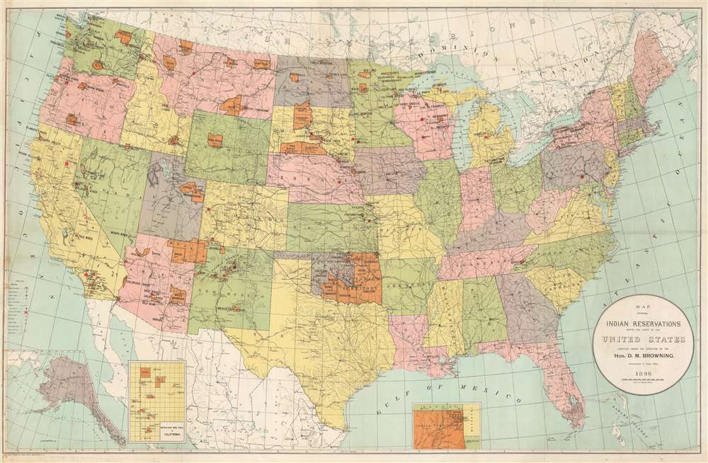
Map Showing Indian Reservations within the Limits of the United States.
1896 (dated) 21.5 x 33.5 in (54.61 x 85.09 cm) 1 : 5500000
1896 (dated) 21.5 x 33.5 in (54.61 x 85.09 cm) 1 : 5500000
Description
This is an 1896 Daniel M. Browning and Office of Indian Affairs map of the United States highlighting Indian reservations. Reservations, the vast majority of which are located west of the Mississippi River, appear in orange. Black block letters identify each reservation. Red stars, triangles, squares, and circles mark non-reservation schools, day schools, boarding schools, and contract schools, respectively.
Indian Reservations
Indian reservations are areas of land managed by an Native American tribe recognized by the U.S. federal government. 326 Indian reservations exist within the United States and each reservation is associated with a specific Native American nation. Of the 574 tribes recognized by the federal government, some have multiple reservations, some have one or share a reservation with another tribe, and some do not have any. While many reservations are small, twelve are larger than the state of Rhode Island. The term 'reservation' has its genesis in the early peace treaties between the independent nations and the U.S. government. In these treaties, many of which were signed under duress or fraud, tribes surrendered large swaths of land to the U.S. government. However, some areas of land were designated as still belonging to the tribes, or in 'reserve', and were often called 'reservations'.Publication History and Census
This map was created under the direction of Daniel M. Browning for the Bureau of Indian Affairs in 1896 and printed by the Norris Peters Company. This map is well represented in institutional collections.CartographerS
Daniel Monroe Browning (October 11, 1846 - January 30, 1903) and an American lawyer, jurist, and government official. Born in Benton, Illinois, Browning received and academic education and graduated from the law school at the State University of Indiana in June 1866. That month, Browning stood before the Illinois Supreme Court to take bar exam and passed. Browning immediately opened a private firm in Benton, however, it appears that he must not have immediately found success, because he taught at the local public school for the next two years. Browning was elected county judge in Franklin County, Illinois (his home county) in November 1869 and was reelected in 1873 and 1877. He was elected to the First Judicial Circuit Court in Illinois in June 1879 and served until 1885, when he again went into private practice. On April 17, 1893, President Cleveland named Browning Commissioner of Indian Affairs. Browning held that position until May 2, 1897, after which he moved to East Saint Louis, where he opened a private law firm in partnership with W.S. Forman. He married Tirzah Isabel Naylor, of Benton, on October 11, 1866, with whom he had three children. More by this mapmaker...
Norris Peters (c. 1834 – July 15, 1889) was a Washington D.C. based photo-lithographer active in the late 18th and early 19th century whom Scientific American called 'one of Washington's most eccentric and mysterious figures.' Peters was born and educated in Pennsylvania. He relocated as a young man to Washington D.C. where he took work as an examiner for the United States Patent Office. During his work with the patent office he became fascinated with the emergent process of photolithography. In 1869 Peters secured substantial venture capital of about 100,000 USD from an unknown investor and founded The Norris Peters Company at 458 Pennsylvania Avenue. Their printing offices have been described as 'unequaled in this or any other country.' From these offices Peters pioneered the development of American photo-lithography. For nearly a generation he held a near monopoly on government photo-lithographic printing. Among their more notable contracts included numerous maps for congressional reports, maps of the U.S. Coast Survey, maps of the U.S. Geological Survey, Mexican currency for the State of Chihuahua, and the Official Gazette of the Patent Office. Peters also maintained an interesting social life and was a confidant to many of the most powerful figures in Congress. He was also a bon vivant known for being an excellent cook and hosting lavish dinners, the invitations to which were 'never declined'. Despite being socially active he never married and died a confirmed bachelor. Following Peters' death in 1889 his business was taken over by Henry Van Arsdale Parsell who administered it until his own death in 1901. The company then merged with Webb & Borcorselski, another D.C. lithography firm, and was renamed Webb & Borcorselski-Norris Peters. They continued to publish under this name well into the mid 20th century. Learn More...
Condition
Good. Exhibits light wear along original fold lines. Exhibits light soiling. Left side remargined.
References
OCLC 1060546193.