This item has been sold, but you can get on the Waitlist to be notified if another example becomes available, or purchase a digital scan.
1904 Jones Map of Indian Reservations within the United States
IndianReservations-jones-1904$250.00


Title
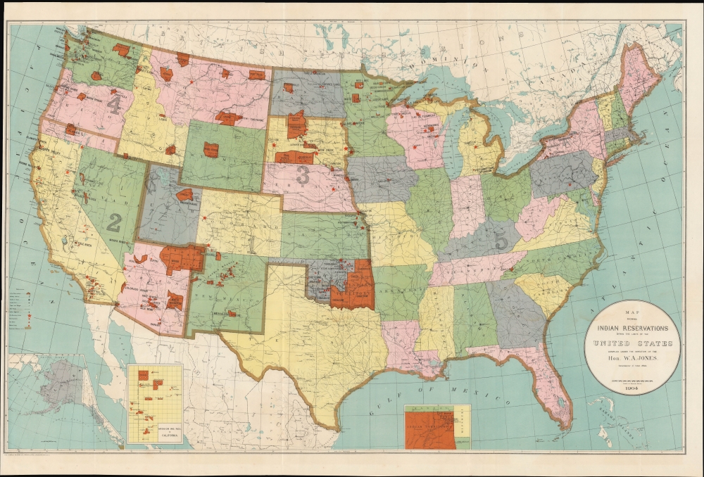
Map Showing Indian Reservations within the Limits of the United States.
1904 (dated) 21.5 x 34 in (54.61 x 86.36 cm) 1 : 5500000
1904 (dated) 21.5 x 34 in (54.61 x 86.36 cm) 1 : 5500000
Description
An impressive large-format 1904 map of the United States highlighting the location of Indian reservations, produced during the tenure of William Arthur Jones as Commissioner of Indian Affairs.
Cities and towns are indicated, as are railroads, military outposts, Indian agencies, and schools of various types on reservations and outside reservation lands. Three insets are situated along the bottom border that illustrate Alaska, the Mission Indian Reservations in California, and the northeastern corner of the Indian Territory.
In 1890, the Oklahoma Organic Act created the Oklahoma Territory from the western half of the Indian Territory and opened the door for land runs on what had been reservation land ('Unassigned Land'). However, tribal governments and courts remained within the Oklahoma Territory, complicating any attempted ascension to statehood. The Curtis Act (1898) remedied this problem by breaking up tribal and communal lands to divide them into individual plots (which had been done elsewhere with the 1887 Dawes Act), in effect abolishing tribal governments and councils. The 'Five Civilized Tribes' (Cherokee, Chickasaw, Choctaw, Creek, and Seminole) responded by attempting to achieve statehood before the Curtis Act could take effect, either with a unified Oklahoma and Indian Territory or the Indian Territory on its own, with the proposed name of Sequoyah. A constitutional convention was called and met in Muskogee on August 21, 1905, drafted a constitution, and sent delegates to the U.S. Congress. President Theodore Roosevelt then brokered a compromise, secured by the Oklahoma Enabling Act in 1906, whereby Oklahoma was admitted as a state but incorporated many elements of the Sequoyah constitution into its own.
A Closer Look
Indian reservations throughout are highlighted in reddish-orange and labeled, with the entire country divided into five districts outlined in brown. Aside from the Indian Territory, several reservations loom especially large in South Dakota, Arizona, and Montana. Many of the reservations seen here were later reduced or eliminated altogether, and a comparison with earlier editions of this map (see 'Publication History and Census' below) shows that, by 1904, several had already been reduce.Cities and towns are indicated, as are railroads, military outposts, Indian agencies, and schools of various types on reservations and outside reservation lands. Three insets are situated along the bottom border that illustrate Alaska, the Mission Indian Reservations in California, and the northeastern corner of the Indian Territory.
Indian Territory
This map was produced some 15 years after the division of the Oklahoma Territory and Indian Territory, but before the subsequent elimination of the latter. The concept of an Indian Territory was the successor to the British Indian Reserve, which was established by the Royal Proclamation of 1763. After the Louisiana Purchase, President Jefferson and his successors viewed land west of the Mississippi River as available for the resettlement of Native Americans, which became official policy after the 1830 Indian Removal Act was signed by President Andrew Jackson. The Indian Territory was slowly whittled down as Americans moved west and more and more territories were formed. Wisconsin, Iowa, and the Dakotas all chipped away at land that had once belonged to Native Americans. The borders of modern-day Oklahoma, to which Indian Territory was eventually reduced, were established by the Kansas-Nebraska Act of 1854.In 1890, the Oklahoma Organic Act created the Oklahoma Territory from the western half of the Indian Territory and opened the door for land runs on what had been reservation land ('Unassigned Land'). However, tribal governments and courts remained within the Oklahoma Territory, complicating any attempted ascension to statehood. The Curtis Act (1898) remedied this problem by breaking up tribal and communal lands to divide them into individual plots (which had been done elsewhere with the 1887 Dawes Act), in effect abolishing tribal governments and councils. The 'Five Civilized Tribes' (Cherokee, Chickasaw, Choctaw, Creek, and Seminole) responded by attempting to achieve statehood before the Curtis Act could take effect, either with a unified Oklahoma and Indian Territory or the Indian Territory on its own, with the proposed name of Sequoyah. A constitutional convention was called and met in Muskogee on August 21, 1905, drafted a constitution, and sent delegates to the U.S. Congress. President Theodore Roosevelt then brokered a compromise, secured by the Oklahoma Enabling Act in 1906, whereby Oklahoma was admitted as a state but incorporated many elements of the Sequoyah constitution into its own.
Native Americans in the Late 19th - Early 20th Century
By the time this map was produced, Native Americans faced immense odds in trying to maintain their traditional culture. The armed resistance of earlier decades was no longer viable and established migration patterns and lifeways were made impossible. Presidential administration of the late 19th century saw peace overtures along with better oversight of the often-unscrupulous Indian Agents and other exploitative profiteers on the frontier. But cultural assimilation was almost universally seen as the best means of preserving peace, leading to boarding schools run by Christian missionaries (who were deputized as Indian Agents) on reservations throughout the country. Nomadic peoples were sedentarized, indigenous languages and religious practice were banned in boarding schools, and collective landholdings broken up into private plots to promote cultural assimilation.Publication History and Census
This map was produced under the direction of William Arthur Jones, the Commissioner of Indian Affairs, and was printed (photo-lithographed) by the Norris Peters Co. in Washington, D.C. Multiple editions of the map exist (including examples from 1885, 1892, and 1896 previously sold by us), which were generally published in Congressional reports, and which can be compared to trace the evolution of reservation lands in the U.S. over time. The present edition is listed among the holdings of six institutions in the OCLC.CartographerS
William Arthur Jones (September 7, 1844 - September 17, 1912) was the 27th Commissioner of Indian Affairs of the United States of America, serving under Presidents William McKinley and Theodore Roosevelt. Born in Wales, his family moved to Wisconsin when he was a child, and he began his career as an educator. Later, he moved into zinc mining and banking, finding great success, and then politics. After serving as mayor of Mineral Point, Wisconsin, he was elected to the Wisconsin State Assembly and then was appointed Commissioner of Indian Affairs by President McKinley in 1897, a post he held until the end of 1904. More by this mapmaker...
Norris Peters (c. 1834 – July 15, 1889) was a Washington D.C. based photo-lithographer active in the late 18th and early 19th century whom Scientific American called 'one of Washington's most eccentric and mysterious figures.' Peters was born and educated in Pennsylvania. He relocated as a young man to Washington D.C. where he took work as an examiner for the United States Patent Office. During his work with the patent office he became fascinated with the emergent process of photolithography. In 1869 Peters secured substantial venture capital of about 100,000 USD from an unknown investor and founded The Norris Peters Company at 458 Pennsylvania Avenue. Their printing offices have been described as 'unequaled in this or any other country.' From these offices Peters pioneered the development of American photo-lithography. For nearly a generation he held a near monopoly on government photo-lithographic printing. Among their more notable contracts included numerous maps for congressional reports, maps of the U.S. Coast Survey, maps of the U.S. Geological Survey, Mexican currency for the State of Chihuahua, and the Official Gazette of the Patent Office. Peters also maintained an interesting social life and was a confidant to many of the most powerful figures in Congress. He was also a bon vivant known for being an excellent cook and hosting lavish dinners, the invitations to which were 'never declined'. Despite being socially active he never married and died a confirmed bachelor. Following Peters' death in 1889 his business was taken over by Henry Van Arsdale Parsell who administered it until his own death in 1901. The company then merged with Webb & Borcorselski, another D.C. lithography firm, and was renamed Webb & Borcorselski-Norris Peters. They continued to publish under this name well into the mid 20th century. Learn More...
Condition
Very good. Original fold lines visible. Minor toning throughout map. Close cropped left margin.
References
OCLC 32068579.