This item has been sold, but you can get on the Waitlist to be notified if another example becomes available, or purchase a digital scan.
1611 Jodocus Hondius Map of India, Southeast Asia and the Philippines
IndiaOrientalis-hondius-1611$750.00

Title
India Orientalis.
1611 (undated) 13.75 x 19 in (34.925 x 48.26 cm) 1 : 11500000
1611 (undated) 13.75 x 19 in (34.925 x 48.26 cm) 1 : 11500000
Description
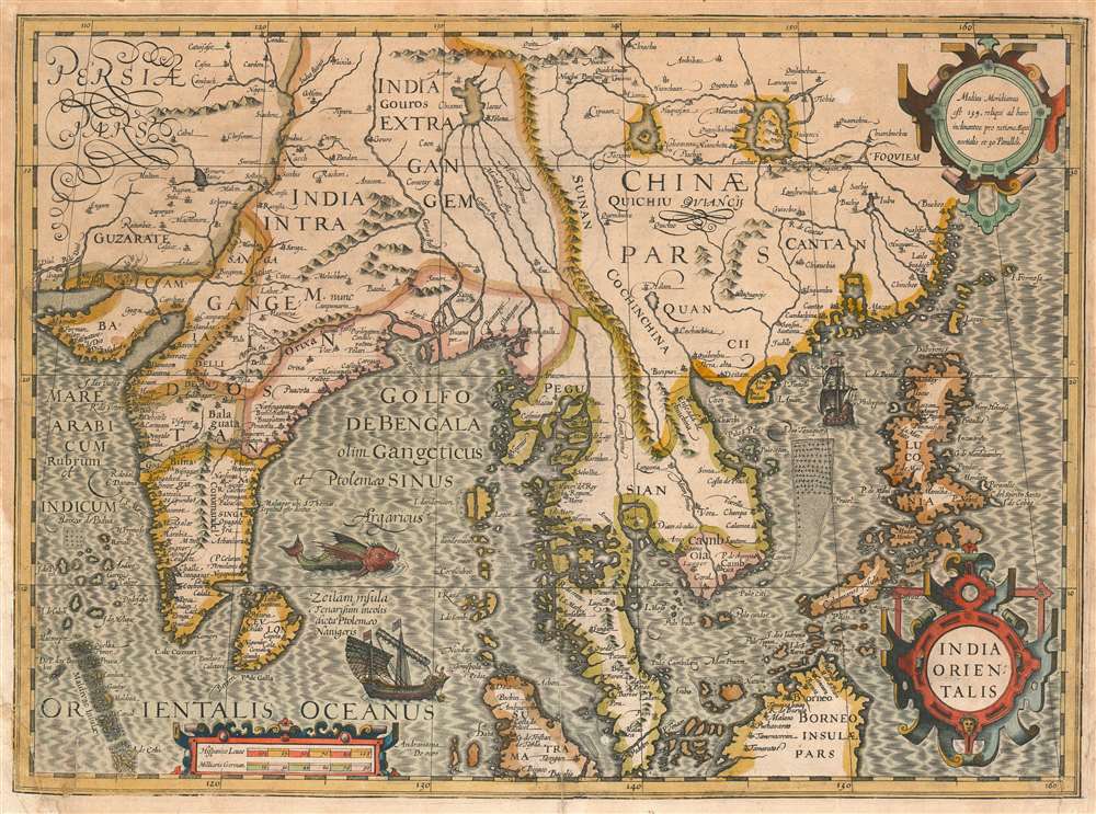
This example of Jodocus Hondius' 1606 map of India, China and Southeast Asia is one of the most beautifully engraved early maps of the region. It is among the 37 maps Hondius added to the plates he had acquired from Mercator's heirs, in order to bring the work up-to-date. The result is vigorous and detailed map, typical of the elder Hondius' engraving. The map encompasses the Indus River valley in the west, and extends east to embrace China and the Philippines. The distorted islands on the Burmese coast represent the Mergui Archipelago. Ayuthaya (Siam) is shown as an island. The Philippines are shown in detail as are the northern coasts of Borneo and Sumatra. Formosa (Taiwan) is named, but it is not accurately depicted. The Indian Ocean is decorated with a sea monster and a Dhow, while a European vessel lays claim to the waters between Luzon and the Chinese coastline.
Aprocryphal Lake Chiamay
The map shares the view of Mercator, Ortelius and Linschoten with respect to South Asia's rivers, showing five between the Ganges and the Mekong originating in the massive, mythical Himalayan lake Chiamay, here located in southeast Asia near the border with India and Tibet. Early cartographers postulated that such a lake must exist to source the important Southeast Asian river systems: the Irrawaddy, the Dharla, the Chao Phraya, and the Brahmaputra. This lake began to appear in maps of Asia as early as the 16th century and persisted well into the mid-18th century. Its origins are unknown but may originate in a lost 16th century geography prepared by the Portuguese scholar Jao de Barros. It was also heavily discussed in the journals of Sven Hedin, who believed it to be associated with Indian legend that a sacred lake, Mansarovar, linked several of the holy subcontinent river systems. There are even records that the King of Siam led an invasionary force to take control of the lake in the 16th century. Nonetheless, the theory of Lake Chiamay was ultimately disproved and it disappeared from maps entirely by the 1760s.Publication History and Census
The map was engraved for inclusion with Jodocus Hondius' 1606 Amsterdam edition of Gerard Mercator's Atlas sive Cosmographicae Meditationes de Fabrica Mundi et Fabricati Figura. Typographical evidence on the verso indicates that this example appeared in the 1611 edition. Perhaps a dozen examples of the separate map, in varying editions, appear in institutional collections in OCLC. The Atlas is well represented in institutional collections; however OCLC lists examples of the 1611 edition in only the Newberry Library the Atheneum Bibliotheek, the Koninklijke Bibliotheek, and Universitats und Landesbibliothek Bonn.Cartographer
Jodocus Hondius (October, 14 1563 - February 12, 1612) was an important Dutch cartographer active in the late 16th and early 17th centuries. His common name, Jodocus Hondius is actually a Latinized version of his Dutch name, Joost de Hondt. He is also sometimes referred to as Jodocus Hondius the Elder to distinguish him from his sons. Hondius was a Flemish artist, engraver, and cartographer. He is best known for his early maps of the New World and Europe, for re-establishing the reputation of the work of Gerard Mercator, and for his portraits of Francis Drake. Hondius was born and raised in Ghent. In his early years he established himself as an engraver, instrument maker and globe maker. In 1584 he moved to London to escape religious difficulties in Flanders. During his stay in England, Hondius was instrumental in publicizing the work of Francis Drake, who had made a circumnavigation of the world in the late 1570s. In particular, in 1589 Hondius produced a now famous map of the cove of New Albion, where Drake briefly established a settlement on the west coast of North America. Hondius' map was based on journal and eyewitness accounts of the trip and has long fueled speculation about the precise location of Drake's landing, which has not yet been firmly established by historians. Hondius is also thought to be the artist of several well-known portraits of Drake that are now in the National Portrait Gallery in London. In 1593, Hondius returned to Amsterdam, where he remained until the end of his life. In 1604, he purchased the plates of Gerard Mercator's Atlas from Mercator's grandson. Mercator's work had languished in comparison to the rival atlas, Theatrum Orbis Terrarum by Ortelius. Hondius republished Mercator's work with 36 additional maps, including several which he himself produced. Despite the addition of his own contributions, Hondius recognizing the prestige of Mercator's name, gave Mercator full credit as the author of the work, listing himself as the publisher. Hondius' new edition of Mercator revived the great cartographer's reputation and was a great success, selling out after a year. Hondius later published a second edition, as well as a pocket version called the Atlas Minor. The maps have since become known as the "Mercator/Hondius series". Between 1605 and 1610 Hondius was employed by John Speed to engrave the plates for Speed's The Theatre of the Empire of Great Britaine. Following Hondius' death in 1612, his publishing work in Amsterdam was continued by his widow and two sons, Jodocus II and Henricus. Later his family formed a partnership with Jan Jansson, whose name appears on the Atlasas co-publisher after 1633. Eventually, starting with the first 1606 edition in Latin, about 50 editions of the Atlas were released in the main European languages. In the Islamic world, the atlas was partially translated by the Turkish scholar Katip Çelebi. The series is sometimes called the 'Mercator/Hondius/Jansson' series because of Jansson's later contributions. Hondius' is also credited with a number of important cartographic innovations including the introduction of decorative map borders and contributions to the evolution of 17th century Dutch wall maps. The work of Hondius was essential to the establishment Amsterdam as the center of cartography in Europe in the 17th century. More by this mapmaker...
Source
Mercator, G./ Hondius, J. Atlas sive Cosmographicae Meditationes de Fabrica Mundi et Fabricati Figura. Amsterdam, 1611.
Condition
Average condition. Mends to centerfold and lower corners. Few wormholes with very slight loss. Else an attractive example with a bold strike.
References
OCLC 605254305. Suarez, Mapping of Southeast Asia, pp. 193-95. Quirino, p. 80. van der Krogt 8400:1A.