This item has been sold, but you can get on the Waitlist to be notified if another example becomes available, or purchase a digital scan.
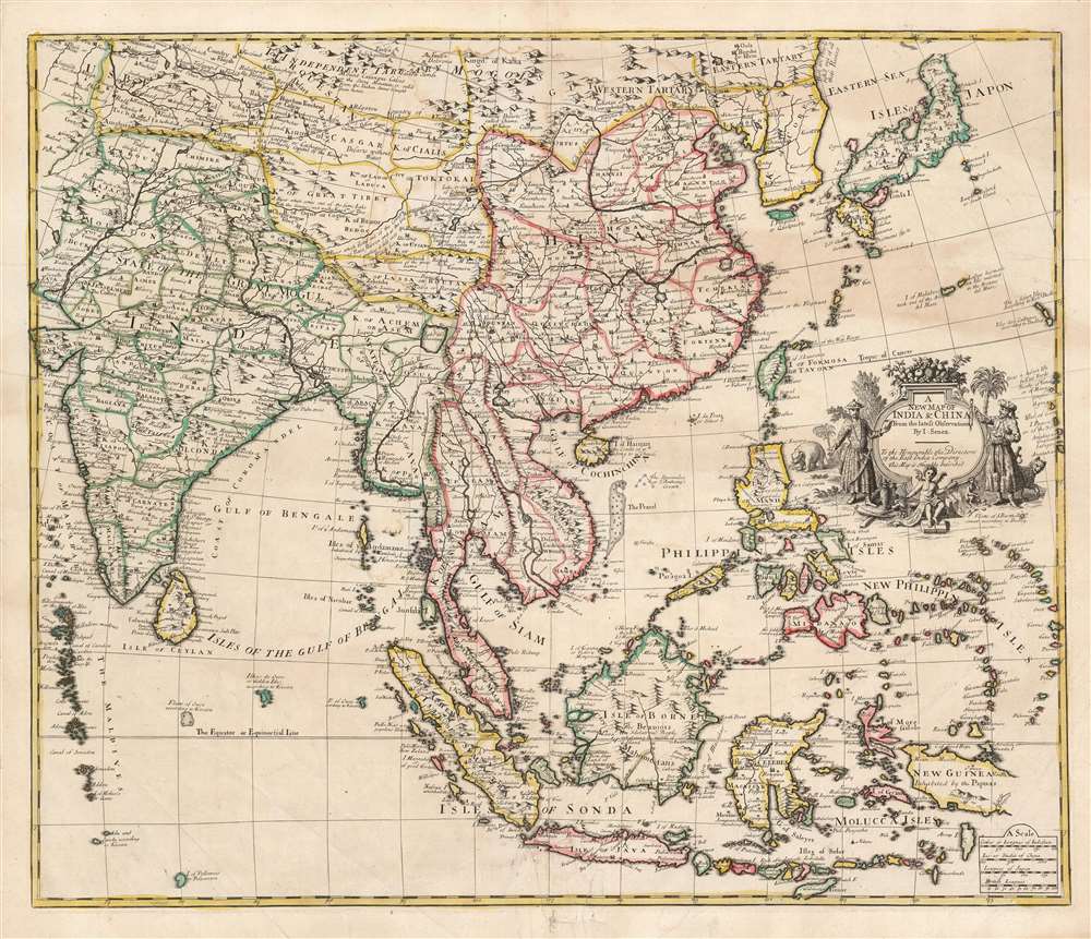
1721 Senex map of the Indies, India, Japan, China and Korea
Indies-senex-1721$1,100.00

Title
A New Map of India and China from the Latest Observations by I. Senex.
1721 (undated) 19.25 x 23 in (48.895 x 58.42 cm) 1 : 11000000
1721 (undated) 19.25 x 23 in (48.895 x 58.42 cm) 1 : 11000000
Description
This is a scarce and elegant 1721 English map of Southeast Asia, the Far East, and the East Indies, drawn and engraved by John Senex. The map is dedicated to the British East Indian Company (EIC) and embraces its primary theaters of operation. At the time the EIC was the wealthiest company in the world and a dominant force in all British affairs, this making this map a subject of great interest to the British public.
The EIC established and maintained trading bases across Asia, establishing its own colonies and taking over those of its rivals. Under Charles II, they began minting currency, received the right to govern territories autonomously, levy armies, make war, and exercise civil and criminal jurisdiction - making them a state-level actor. By the time this map was published, the EIC had overpowered or merged with all competition and was the largest and wealthiest company in the world.
A Closer Look
Following the convention of the prior century, the map encompasses all of what would have been termed 'The Indies': spanning from the mouth of the Indus River and the Maldives Islands in the west, to the Mariana Islands, and an expanse of islands east of the Philippines (the 'New Phillipin Isles') in the general location of, but bearing little resemblance to, the Caroline Islands. The map thus embraces the Spice Islands, the Malay Peninsula, China, Japan, and Korea. Afghanistan and much of Central Asia also appear.The Latest Authorities
Senex's map represents the passage, to an English audience, of the state-of-the-art geographical knowledge of Guillaume De l'Isle, the preeminent mapmaker of Paris (and consequently of all Europe). Senex further includes islands mapped by the 17th-century maps of English geographer Robert Dudley and notes these additions prominently in order to give an English mapmaker pride of place. Although Senex refers in several places to the Portuguese geographer Texeira, the chief source for the map - De l'Isle - is nowhere credited.An Exotic Cartouche
The map's title cartouche, in the tradition of the decorative maps of the 17th century, sets the tone with an assortment of images representing the sort of people to be found in the mapped area, and the treasures available to those bold enough to travel there. A putto rests in the foreground amongst maps, silks, elephant tusks, and China vases. A monkey sits eating fruit, oblivious to a prowling leopard. In the background, an elephant towers. Flanking the fruit-bedecked cartouche are a Chinese warrior and a Mogul - in poses presenting all to the reader.East India Company
The map is dedicated to the 'Directors of the East India Company' (EIC) - a natural entity for Senex to so flatter. The EIC was founded in 1600 with a Royal Charter granting a monopoly over the lucrative trade with all lands east of the Cape of Good Hope and west of the Straights of Magellan. The Company was overseen by a governor and 24 Directors, referenced here in the dedication.The EIC established and maintained trading bases across Asia, establishing its own colonies and taking over those of its rivals. Under Charles II, they began minting currency, received the right to govern territories autonomously, levy armies, make war, and exercise civil and criminal jurisdiction - making them a state-level actor. By the time this map was published, the EIC had overpowered or merged with all competition and was the largest and wealthiest company in the world.
Publication History and Census
This map was engraved by John Senex for inclusion in his New General Atlas, printed in London by the publisher Daniel Browne in 1721, with editions appearing as late as 1740. Despite being an atlas issue, this map is scarce with only eight examples cataloged separately in OCLC. Uncommon on the market.CartographerS
John Senex (1678 - 1740) was an English engraver and map maker active in London during the first half of the 18th century. Senex was born to upper middle class parents in Shropshire, England. As a young man, he was apprenticed to Robert Clavell, a London bookseller and member of the Stationers' Company, under whom he mastered the arts of engraving and printmaking. Around 1702 Senex completed his apprenticeship and established himself as a printer and bookseller in the Strand. A year later Senex partnered with Jeremiah Seller and Charles Price, the successors to the important mapmaker John Seller, and relocated to Cornhill. This was likely Senex's first introduction to mapmaking though he seems to have taken to it with abandon. In the subsequent years Senex established himself as one of the most prominent cartographers in London, publishing a number of beautiful and important maps that today rank among the finest examples from the Golden Age of British Cartography. In addition to a large corpus of flat maps, Senex also produced a number of important and highly desirable globes. Eventually Senex dissolved his partnership with Seller and Price and relocated to Fleet Street, where he maintained offices until his death in 1740. Senex was succeeded by his widow, Mary Senex, who continued to publish and update his works until about 1755, when the remaining globe and map plates were sold to James Ferguson. More by this mapmaker...
Guillaume De l’Isle (1675 - 1726) was a French cartographer, and arguably the finest mapmaker at the beginning of the eighteenth century. He was the son of Claude De L'Isle (1644 -1720), a Paris-based historian and geographer under Nicholas Sanson, then the leading light of French cartography. He was the chief proponent of the school of 'positive geography' and the primary figure defining the heights of the Golden Age of French Cartography. Guillaume's skill as a cartographer was so prodigious that he drew his first map at just nine years of age. He was tutored by J. D. Cassini in astronomy, science, mathematics and cartography. By applying these diverse disciplines to the vast stores of information provided by 18th century navigators, Guillaume created the technique that came to be known as 'scientific cartography', essentially an extension of Sanson's 'positive geography'. This revolutionary approach transformed the field of cartography and created a more accurate picture of the world. Among Guillaume's many firsts are the first naming of Texas, the first correct map of the Mississippi, the final rejection of the insular California fallacy, and the first identification of the correct longitudes of America. Stylistically De L'Isle also initiated important changes to the medium, eschewing the flamboyant Dutch style of the previous century in favor of a highly detailed yet still decorative approach that yielded map both beautiful and informative. Guillaume was elected to the French Academie Royale des Sciences at 27. Later, in 1718, he was also appointed 'Premier Geographe du Roi', an office created especially for him. De L'Isle personally financed the publication of most of his maps, hoping to make heavy royalties on their sales. Unfortunately he met an untimely death in 1728, leaving considerable debt and an impoverished child and widow. De L'Isle's publishing firm was taken over by his assistant, Phillipe Buache, who would also become his son in law. Learn More...
Sir Robert Dudley (August 7, 1573 - September 6, 1649) was an English explorer and cartographer, the publisher of the Dell’Arcano de Mare, one of the greatest nautical atlases of all time. He was the illegitimate son of Robert Dudley, 1st Earl of Leicester (a favorite of Queen Elizabeth I) and Douglas Sheffield, the widow of John Sheffield, 2nd Baron Sheffield. In 1594, Dudley led an expedition across the Atlantic, with the intent of harassing Spanish merchantmen. His expedition met with a series of misfortunes, but successfully returned to England the following year. In 1596, Dudley joined an expedition led by Robert Devereux, 2nd Earl of Essex, against Cadiz. He served as the commander of the Nonpareil, and was knighted for his conduct in the capture of Cadiz. In 1603, Dudley made an attempt to establish his legitimacy at court and gain several inheritances, after being (possibly erroneously) informed that his parents had been secretly married. No concrete proof of the marriage could be furnished, thus the judgement was handed down against him in May 1605. Dudley left England in July of the same year, with his lover and cousin Elizabeth Southwell, who was disguised as his page. They married in Lyon in 1606 having received a papal dispensation. The couple settled in Florence, where Dudley began using his father’s title, Earl of Leicester, and his uncle’s, Earl of Warwick. In Florence, Dudley designed and built warships for the arsenal at Livorno and became a naval advisor to Ferdinand I, Grand Duke of Tuscany. In 1607, James I revoked Dudley’s travel license once ordered that he return to provide for his deserted wife and family. Dudley refused, was subsequently labeled an outlaw, and his estate was confiscated. By far Dudley’s most important work was the Dell’Arcano del Mare (Secrets of the Sea). His most celebrated achievement, is the atlas of sea charts of the world which accompanied the work. This maritime atlas was the first nautical atlas of the entire world in print, the first made by an Englishman, the first to show prevailing winds and currents, and the first to use the Mercator projection throughout. Learn More...
Source
Senex, John, A New General Atlas, (London: Brown) 1721.
Condition
Good. Surface mends at bottom centerfold, assorted creases and some areas of staining. Else very good with original outline color.
References
OCLC 12205042.