This item has been sold, but you can get on the Waitlist to be notified if another example becomes available.
1961 Army Map Service Far East Map of French Indochina
IndochineFrancaise-ams-1961$250.00


Title
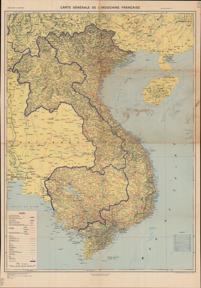
Carte Générale de l'Indochine Française.
1961 (dated) 38.75 x 27 in (98.425 x 68.58 cm) 1 : 2000000
1961 (dated) 38.75 x 27 in (98.425 x 68.58 cm) 1 : 2000000
Description
Encapsulating decades of warfare in Southeast Asia, this is a U.S. Army Map Service Far East map of French Indochina. Originally created by the French soon after the reoccupation of Vietnam following World War II, this map's evolution (see Publication History below) traces Western involvement in Vietnam, where the American army took over after the French defeat.
A Closer Look
Depicting the entirety of modern-day Vietnam, Cambodia, and Laos (collectively known as French Indochina during the French colonial era), cities, towns, and villages are identified, and highways, roads, and railroads are illustrated. When the French created this map in 1945, the purple international boundaries were not used. These were added by the Army Map Service, likely during the 1961 revision. A bilingual English and French legend occupies the lower left corner.The Vietnam War
The Vietnam War, known in Vietnam as the Resistance War Against America or simply the American War, raged between November 1, 1955, and April 30, 1975, when Saigon fell to the North Vietnamese. A complicated conflict with an even more complicated history and legacy, the Vietnam War pitted the North Vietnamese, led by Ho Chi Minh, against the South Vietnamese. The South Vietnamese were supported by the United States, while the Soviet Union and China supported the North Vietnamese. American anti-communist dogma and fear that 'if one country fell to Communism, then more would fall' drove participation in the far-off civil war. As the conflict grew, American involvement became increasingly overt. Finally, in 1964, American ground troops were sent into combat. In 1968, U.S. troop strength in Vietnam reached its maximum at 549,500 soldiers. The same year saw the Tet Offensive, the most successful North Vietnamese campaign against American forces, and a waning of American home front support. U.S. forces withdrew in January 1973, and Saigon fell to the North Vietnamese on April 30, 1975.Publication History and Census
This map was first drafted in 1945 by the Institut Géographique National during the French reoccupation of Vietnam after the Japanese surrender at the end of World War II. It was then revised in 1948 by the Service Géographique de l'Indochine, two years into the First Indochina War. The U.S. Army Map Service then copied the map in 1951. The present example represents an edition that was revised by the U.S. Army Map Service Far East (USAMSFE) in March 1961 and published in April 1961 by the USAMSFE. This is the only known cataloged example of the present edition.Cartographer
The Army Map Service (AMS) (1941 - 1968) was the military cartographic agency of the U.S. Department of Defense and part of the U.S. Army Corps of Engineers. The AMS compiled, published, and distributed military topographical maps and other related materials for use by the U.S. Armed Forces. They also prepared maps for space exploration, intelligence reports, and the establishment of world geodetic control networks. Formed during World War II, by the end of the war the Army Map Service had prepared 40,000 maps. 3,000 different maps were created for the Normandy invasion alone. The AMS was instrumental in the Korean War and the Vietnam War, and during all three of these conflicts distributed tens of millions of maps to U.S. servicemen. On September 1, 1968, the AMS was resdesignated the U.S. Army Topographic Command, and continued under this name as an independent organization until January 1, 1972 when it was merged with the new Defense Mapping Agency and renamed the DMA Topographic Center. The Defense Mapping Agency was added to the National Imagery and Mapping Agency on October 1, 1996, which was redesigned the National Geospatial-Intelligence Agency in 2003. More by this mapmaker...
Condition
Good. Light wear and toning along original fold lines. Closed margin tears professionally repaired on verso. Slight loss at two fold intersections. Small area of infill to left margin. Top right corner reattached. Some soiling.