This item has been sold, but you can get on the Waitlist to be notified if another example becomes available, or purchase a digital scan.
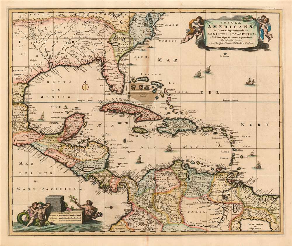
1680 Visscher Map of the Caribbean, Florida, Central America and Terra Firma
InsulaeAmericanae-visscher-1680$1,000.00

Title
Insulae Americanae in Oceano Septentrionali ac regiones adiacentes: a C. de May usque ad Lineam Aequinoctialem.
1708 (undated) 18 x 22 in (45.72 x 55.88 cm) 1 : 10000000
1708 (undated) 18 x 22 in (45.72 x 55.88 cm) 1 : 10000000
Description
This is Nicolas Visscher II's c. 1680 map of the West Indies, one of the first maps in the lineage of Dutch maps of the region to detail inland areas rather than strictly adhering to coastlines. The map shows the Caribbean Islands, the eastern part of Mexico, Central America, the northern part of South America, Florida, and an area now part of Georgia and South Carolina. Oddly, this area is named French Florida (Florida Galli) despite the reality that the French colonies in the area had been destroyed by the Spanish well before this map was drawn. The map extends as far north as Virginia and Delaware Bay.
Geographical Improvements
The Visscher family generally employed larger plates and finer detail than the mapmakers of the first half of the 17th century, generally improving the clarity of the maps and allowing the addition of more geographical data. The chief improvement added to this map (over the Blaeu and Jansson maps of the same title) is the richly detailed mapping beyond the coastlines. Visscher's map compiles the detail that would have been found spread over five separate maps earlier in the seventeenth century; the improvements in the engravers' art over the course of the Dutch Golden Age is evident.Cartouche
The map's beautiful cartouches are classics of the form. The title of the map is presented on a banner suspended by a quartet of putti. In the lower left corner, the scales are displayed on a plinth surrounded with an aquatic scene of nereids sporting with an ichthyocentaur (that is a creature with the body of a man, front legs of a horse, tail of a fish.) One of the nereids holds aloft a berried branch with a level of delight that would be difficult to explain - if the branch did not so closely resemble that of the coca plant, which was reputed by South American indigenes to have euphoric qualities.Publication History and Census
Examples of this map have been catalogued in examples of Jansson's Novus Atlas of 1657-58. It appears likely that these were added to the work at a later date, as further bibliographical evidence suggests that this map was executed by Nicolas Visscher II rather than his father. Burden dates the earliest state of this map (without the privilege) as c. 1680. It was one of the newer maps added to Visscher's Atlas Minor, the composite atlas published by the family starting in the mid-1670 and continuing without change into the 18th century. The presence of latitude and longitude lines on this example conforms to Burden's third, c. 1708 state of the map. Fifteen examples of the Atlas Minor appear in OCLC with varying pagination; the map itself is well represented in institutional collections.Cartographer
Claes Jansz Visscher (1587 - 1652) established the Visscher family publishing firm, which were prominent Dutch map publishers for nearly a century. The Visscher cartographic story beings with Claes Jansz Visscher who established the firm in Amsterdam near the offices of Pieter van den Keer and Jadocus Hondius. Many hypothesize that Visscher may have been one of Hondius's pupils and, under examination, this seems logical. The first Visscher maps appear around 1620 and include numerous individual maps as well as an atlas compiled of maps by various cartographers including Visscher himself. Upon the death of Claes, the firm fell into the hands of his son Nicholas Visscher I (1618 - 1679), who in 1677 received a privilege to publish from the States of Holland and West Friesland. The firm would in turn be passed on to his son, Nicholas Visscher II (1649 - 1702). Visscher II applied for his own privilege, receiving it in 1682. Most of the maps bearing the Visscher imprint were produced by these two men. Many Visscher maps also bear the imprint Piscator (a Latinized version of Visscher) and often feature the image of an elderly fisherman - an allusion to the family name. Upon the death of Nicholas Visscher II, the business was carried on by the widowed Elizabeth Verseyl Visscher (16?? - 1726). After her death, the firm and all of its plates was liquidated to Peter Schenk. More by this mapmaker...
Source
Visscher, Nicolas II Atlas Minor Amsterdam c. 1708
Condition
Good condition. Some staining and minor wear at centerfold.
References
Rumsey 0210.000. OCLC 500909193. Burden 531 state 3.