1726 Stocklein / Klein Map of the Mariana and Philippine Islands
InsulaeMarianae-stocklein-1726$700.00

Title
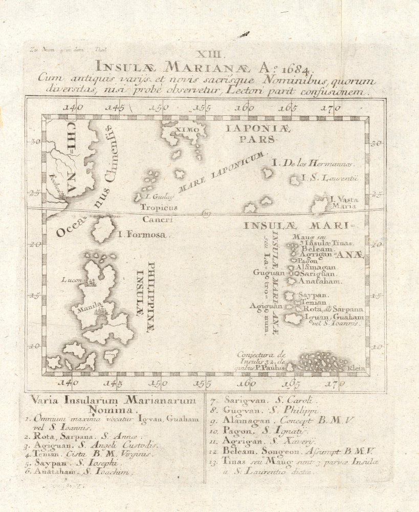
XIII. Insulae Marianae Ao. 1684 cum antiquis variis et novis sacrisque nominibus, quorum diversitas, nisi probé observateur, lectori parit confusionem.
1726 (undated) 10.5 x 8.75 in (26.67 x 22.225 cm) 1 : 21000000
1726 (undated) 10.5 x 8.75 in (26.67 x 22.225 cm) 1 : 21000000
Description
This is Joseph Stöcklein's c. 1726 map of the Mariana Islands and surrounding islands in the western Pacific. Among other features, it is notable for including the existence of islands posited by Father Paul Klein, Stocklein's fellow Jesuit, who developed early maps of this region based on his interactions with Palauan sailors.
The 'Islas de los Hermannos' are the Ogasawara Islands, while the nearby Isla San Laurenti and Isla Vasta Maria may be the islands of Iwo Jima and Farallon de Pajaros, greatly exaggerated in size. Further south, we are on more solid ground with recognizable islands like Maug, Pagan, Saipan, Tinian, and Guam. Below the Marianas are 32 'conjectured' islands mentioned by Paul Klein, the result of a chance meeting on a beach in the Philippines.
A Closer Look
The map covers from the southeastern coast of China (Fuzhou, here as Focheu) and Kyūshū ('Ximo') to the Philippine Islands, Mariana Islands, and possibly northern Caroline Islands. The main focus is the Mariana (or 'Bandits') Islands at right, which are named on the map and listed at bottom, both with an approximation of their indigenous name and a Latin name, mostly the names of saints.The 'Islas de los Hermannos' are the Ogasawara Islands, while the nearby Isla San Laurenti and Isla Vasta Maria may be the islands of Iwo Jima and Farallon de Pajaros, greatly exaggerated in size. Further south, we are on more solid ground with recognizable islands like Maug, Pagan, Saipan, Tinian, and Guam. Below the Marianas are 32 'conjectured' islands mentioned by Paul Klein, the result of a chance meeting on a beach in the Philippines.
Cartographic Cobbling
In 1696, the polymath Jesuit Paul Klein (Pablo Clain or Pauli Klain) met a group of Palauans on the Philippine island of Samar who had been blown off course and landed there. After discussing their homeland with Klein, the Palauans set out a series of pebbles on a beach to draw a rough chart of the island chain and other nearby islands. Klein used this representation to develop a sketch map, adding inferences about islands' locations and distance from the Philippines, and included it with a letter to his Jesuit superiors in Rome, after which it became gradually known throughout Europe. Meanwhile, Spanish explorers were progressively discovering other islands in Micronesia, which combined with Klein's letter led to the islands garnering significant interest in Europe (for more information on this fascinating combination of European and indigenous cartography, see our listing of the map of the Caroline Islands that appeared in Stocklein's Neue Weltbott, InsulaePalaos-stocklein-1726).Publication History and Census
This map appeared in Stöcklein's Der Neue Weltbott mit allerhand Nachrichten dern Missionariorum Societatis Jesu, published between 1728 and 1758 (the map itself is generally dated to 1726). This map is only independently cataloged among the holdings of the Sächsische Landesbibliothek - Staats- und Universitätsbibliothek Dresden, while Stöcklein's entire work is also very rare in institutional collections and on the market.Cartographer
Joseph Stöcklein [Stoecklein] (July 30, 1676 – December 28, 1733) was a Jesuit priest, missionary, and scholar active in the late 17th and early 18th centuries. He was born in Oettingen, Germany and joined the Jesuit order in Vienna around 1700. He served as a priest in military encampments where he became popular as a preacher. Afterwards he became the head of the Jesuit library in Graz, Switzerland, a position he maintained for six years. During this tenure he began work on his opus, the Welt-Bott, a vast compilation of Jesuit missionary letters and narratives translated into vernacular German intended both to glorify the priesthood and share valuable information about the world. Today this work is exceedingly rare. More by this mapmaker...
Source
Stocklein, J., Neuer Welt-bott..., (Augsburg: Grätz) 1728.
Condition
Very good. Printing faded.
References
OCLC 859528520.