This item has been sold, but you can get on the Waitlist to be notified if another example becomes available, or purchase a digital scan.
1659 Blaeu Introduction to Cosmography, with Celestial Charts
Introduccion-blaeu-1659$150.00


Title
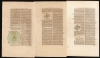
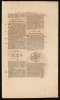
Introduccion a la Cosmographia y sus Partes (Chapters 1-4).
1659 (undated) 14.5 x 9.5 in (36.83 x 24.13 cm)
1659 (undated) 14.5 x 9.5 in (36.83 x 24.13 cm)
Description
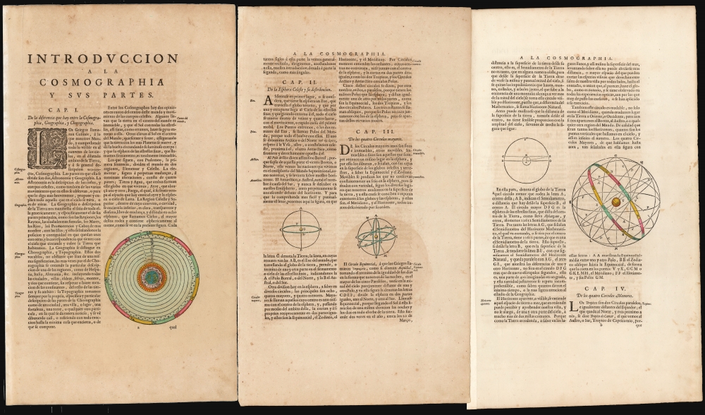
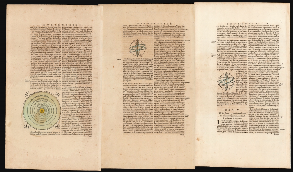
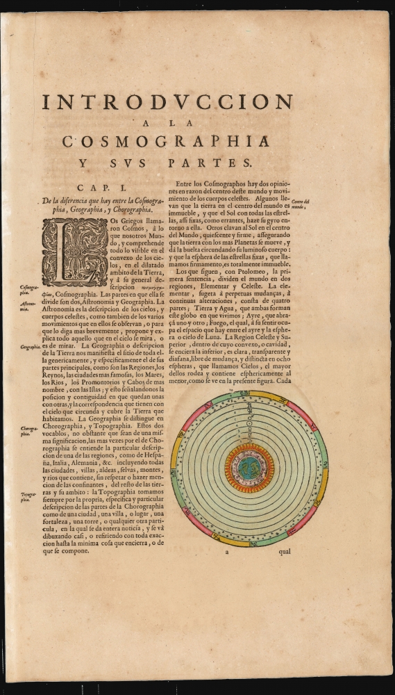
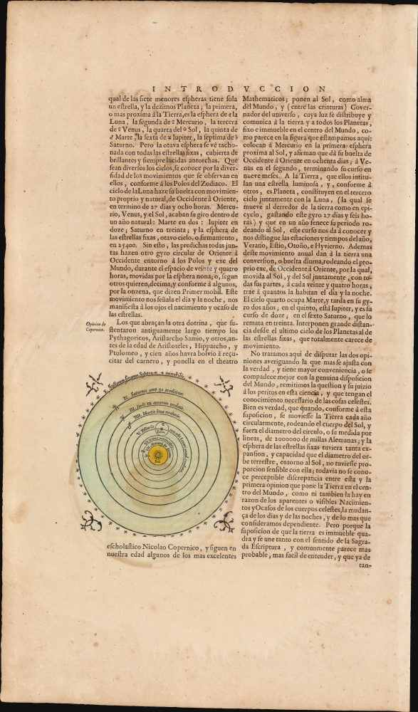
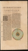
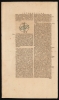
These are the first four chapters of the introduction to Cosmography published in the first volume of Joan Blaeu's 1659 Spanish-text Nuevo Atlas. It includes elegantly-engraved charts illustrating the text's descriptions of important concepts, the most beautiful of which are the two planispheres depicting the Ptolemaic, geocentric system and the Copernican solar system. These represent the only separate celestial charts to appear in Blaeu atlases.
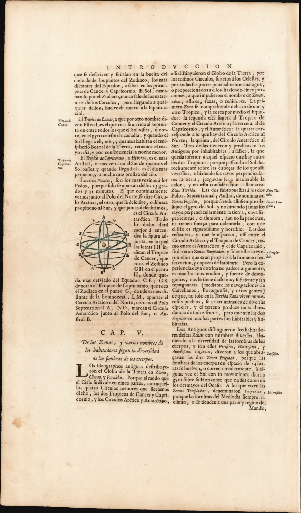
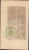
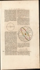
Six further diagrams illustrate the elements of the celestial sphere relating to the study of both astronomy and geography: the poles, the equator, the tropics, the equinoxes, the circle of the zodiac.
A Closer Look
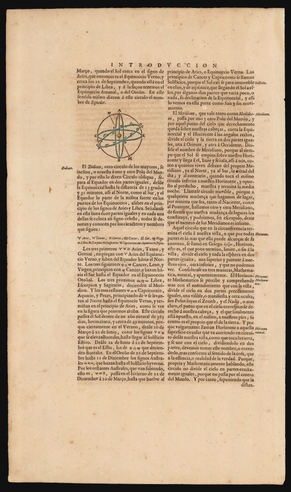
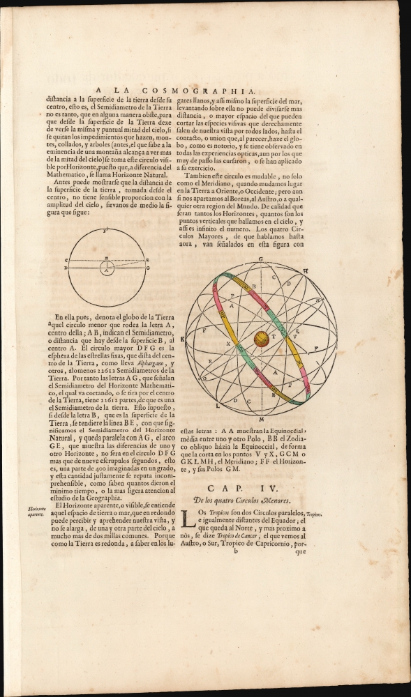
The three sheets of text describe the basic principles of cosmology, via the separate disciplines of Cosmography, Geography, and Chorography. Blaeu's description divides cosmographers into two groups: those who believe that the Earth sits, immobile, in the center of the universe, and another group who argue that the cosmos is centered on an immobile sun, and that the planets move about it. In that context, Blaeu has included two elegantly-engraved planispheres. The first, derived from the ancient Alexandrian astronomer and arch-geographer Ptolemy, depicts a geocentric system: the Earth is in the center, surrounded first by elemental spheres and then by the celestial spheres. The second (on the verso of this sheet) depicts the Copernican solar system wherein the sun forms the center of the cosmos, with the planets in their spherical orbits around it. Neither system includes the planets beyond Saturn (these had not yet been discovered) and both suppose the outermost sphere to be a fixed limit, with the stars immobile upon it.Six further diagrams illustrate the elements of the celestial sphere relating to the study of both astronomy and geography: the poles, the equator, the tropics, the equinoxes, the circle of the zodiac.
Publication History and Census
These engravings were included in the introductory matter for Blaeu's atlases as early as 1635, and many were likely reused from Blaeu's earlier published work. For example, the Copernican planisphere was included in Blaeu's 1617 edition of Copernicus' Astronomia Instaurata. These sheets conform typographically to those found in the 1659 Spanish text Nuevo Atlas.CartographerS
Willem Janszoon Blaeu (1571 - October 18, 1638), also known as Guillaume Blaeu and Guiljelmus Janssonius Caesius, was a Dutch cartographer, globemaker, and astronomer active in Amsterdam during the late 16th and early 17th centuries. Blaeu was born 'Willem Janszoon' in Alkmaar, North Holland to a prosperous herring packing and trading family of Dutch Reformist faith. As a young man, he was sent to Amsterdam to apprentice in the family business, but he found the herring trade dull and instead worked for his cousin 'Hooft' as a carpenter and clerk. In 1595, he traveled to the small Swedish island of Hven to study astronomy under the Danish Enlightenment polymath Tycho Brahe. For six months he studied astronomy, cartography, instrument making, globe making, and geodesy. He returned to Alkmaar in 1596 to marry and for the birth of his first son, Johannes (Joan) Blaeu (1596 – 1673). Shortly thereafter, in 1598 or 1599, he relocated his family to Amsterdam where he founded the a firm as globe and instrument makers. Many of his earliest imprints, from roughly form 1599 - 1633, bear the imprint 'Guiljelmus Janssonius Caesius' or simply 'G: Jansonius'. In 1613, Johannes Janssonius, also a mapmaker, married Elizabeth Hondius, the daughter of Willem's primary competitor Jodocus Hondius the Elder, and moved to the same neighborhood. This led to considerable confusion and may have spurred Willam Janszoon to adopt the 'Blaeu' patronym. All maps after 1633 bear the Guiljelmus Blaeu imprint. Around this time, he also began issuing separate issue nautical charts and wall maps – which as we see from Vermeer's paintings were popular with Dutch merchants as decorative items – and invented the Dutch Printing Press. As a non-Calvinist Blaeu was a persona non grata to the ruling elite and so he partnered with Hessel Gerritsz to develop his business. In 1619, Blaeu arranged for Gerritsz to be appointed official cartographer to the VOC, an extremely lucrative position that that, in the slightly more liberal environment of the 1630s, he managed to see passed to his eldest son, Johannes. In 1633, he was also appointed official cartographer of the Dutch Republic. Blaeu's most significant work is his 1635 publication of the Theatrum orbis terrarum, sive, Atlas Novus, one of the greatest atlases of all time. He died three years later, in 1638, passing the Blaeu firm on to his two sons, Cornelius (1616 - 1648) and Johannes Blaeu (September 23, 1596 - December 21, 1673). Under his sons, the firm continued to prosper until the 1672 Great Fire of Amsterdam destroyed their offices and most of their printing plates. Willem's most enduring legacy was most likely the VOC contract, which ultimately passed to Johannes' son, Johannes II, who held the position until 1617. As a hobbyist astronomer, Blaeu discovered the star now known as P. Cygni. More by this mapmaker...
Joan (Johannes) Blaeu (September 23, 1596 - December 21, 1673) was a Dutch cartographer active in the 17th century. Joan was the son of Willem Janszoon Blaeu, founder of the Blaeu firm. Like his father Willem, Johannes was born in Alkmaar, North Holland. He studied Law, attaining a doctorate, before moving to Amsterdam to join the family mapmaking business. In 1633, Willem arranged for Johannes to take over Hessel Gerritsz's position as the official chartmaker of the Dutch East India Company, although little is known of his work for that organization, which was by contract and oath secretive. What is known is his work supplying the fabulously wealthy VOC with charts was exceedingly profitable. Where other cartographers often fell into financial ruin, the Blaeu firm thrived. It was most likely those profits that allowed the firm to publish the Theatrum Orbis Terrarum, sive, Atlas Novus, their most significant and best-known publication. When Willem Blaeu died in 1638, Johannes, along with his brother Cornelius Blaeu (1616 - 1648) took over the management of the Blaeu firm. In 1662, Joan and Cornelius produced a vastly expanded and updated work, the Atlas Maior, whose handful of editions ranged from 9 to an astonishing 12 volumes. Under the brothers' capable management, the firm continued to prosper until the 1672 Great Amsterdam Fire destroyed their offices and most of their printing plates. Johannes Blaeu, witnessing the destruction of his life's work, died in despondence the following year. He is buried in the Dutch Reformist cemetery of Westerkerk. Johannes Blaeu was survived by his son, also Johannes but commonly called Joan II, who inherited the family's VOC contract, for whom he compiled maps until 1712. Learn More...
Source
Joan Blaeu, Joan, Nuevo Atlas, (Amsterdam: Blaeu) 1659.
The classic Dutch atlas, whose publication ushered in the Dutch golden age of cartography. Willem Jansz Blaeu had been, since 1604, producing engraved maps for sale; these were separate issues (and all consequently extremely rare) until the publishing of Blaeu's Appendix in 1630 and 1631, which also included a number of maps purchased from the widow of Jodocus Hondius, (for example his famous iteration of John Smith's map of Virginia.) In 1634, he announced his intention to produce a new world atlas in two volumes, entitled Theatrum Orbis Terrarum, sive Atlas Novus (Théâtre du Monde ou Nouvel Atlas) (in an effort to invoke the successful work of the same title produced by Ortelius the previous century, while reinforcing the notion of it being a new work.) This work was published first in German in 1634, followed by Latin, Dutch and French editions in 1635. Blaeu's maps have always been noted for the quality of their paper, engraving and fine coloring, and this was the intent from the very start. The 1634 announcement of the upcoming work described it: 'All editions on very fine paper, completely renewed with newly engraved copperplates and new, comprehensive descriptions.' (van der Krogt, p,43) Many of the most beautiful and desirable maps available to the modern collector were printed and bound in Blaeu's atlases. Willem's son, Joan, would go on to add further volumes to the Atlas Novus, concurrently printing new editions of the first two volumes with additional maps, in effect making these new editions an entirely new book. Under Joan there would be nine Latin editions, twelve French, at least seven Dutch, and two German. This exceedingly successful work would be the mainstay of the Blaeu firm until 1661, at which point the work was supplanted by Joan Blaeu's masterwork Atlas Maior in 1662.
Condition
Very good. Original hand color. Three half folio sheets. Measurements are for printed surface of each.