1944 Chapin Map of the Presumed Allied Invasion of 'Fortress Europe'
Invasionland-chapin-1944-2$550.00

Title
Invasionland.
1944 (dated) 43 x 21.75 in (109.22 x 55.245 cm) 1 : 1360000
1944 (dated) 43 x 21.75 in (109.22 x 55.245 cm) 1 : 1360000
Description
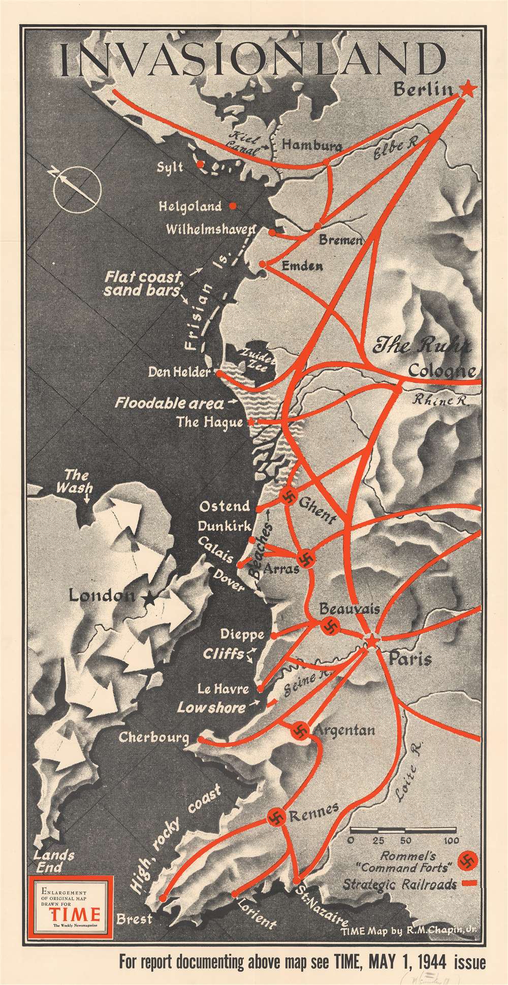
Perhaps the worst best-kept secret of World War II, by the spring of 1944 everyone was anticipating the Allied invasion of Northern Europe. This map, created by Robert M. Chapin, Jr., encapsulates that anticipation, speculating where American and British forces would land. Here, numerous locations along the coast are identified, including Calais (which was believed to be the most likely location for the invasion), Dunkirk (the site of the storied evacuation of British and French troops), Cherbourg, Brest, and even Wilhelmshaven, the German submarine base. The thick red lines indicate major railways, where it would be easiest for the Germans to quickly relocate forces in response to an invasion. The swastikas inscribed in red circles mark 'command forts' constructed by Rommel to help repel the expected invasion.
When and Where Will the Invasion Happen
Through 1942 and 1943, American and British troops fought their way across North Africa, Sicily, and Italy, reversing German and Italian gains. The Soviet Red Army, after years of brutal fighting on the Eastern Front, turned the tide and were marching across Eastern Europe toward Berlin. Now it was expected that Allied troops would undertake an amphibious assault somewhere along the coast of northern Europe. Conventional wisdom on both sides believed that Calais would be the site, since only twenty miles separated Britain from France.Where Did the Invasion Actually Occur?
Since the D-Day Invasion in Normandy happened seventy-five years ago, we know the actual invasion point, the Normandy coast. Here, that part of the French coast is not even highlighted here as a possibility. Situated between Cherbourg and Le Havre, the only notation here is that there is 'low shore' near Le Havre and the mouth of the Seine. While that is true, troops landing at Omaha Beach a little over a month after this map was published faced cliffs and bluffs, making their exit from the beachhead difficult. Although popular history remembers D-Day almost as a 'sure-thing', in reality, the operation was much more tenuous and, if events had gone even slightly differently, may not have been as successful. In the end, the courage and valor of the Allied troops that hit the beaches and parachuted in managed to secure enough territory to continue pushing inland making the invasion a success.Publication History
This map was created by Robert M. Chapin, Jr, and originally published with an article in Time in May 1944. The current example is an enlargement of that original map.Cartographer
Robert M. Chapin Jr. (fl. 1933 - 1970) was a prominent architect, cartographer and illustrator active during World War II and the Cold War. Chapin graduated from the University of Pennsylvania in 1933 with a degree in architecture. Since this was the height of the Great Depression, and architects in low demand, he instead took work as a staff cartographer at Newsweek. Catching the attention of Manfred Gottfried of Time, Chapin was offered an accepted a position at the head of Time's cartography department. He remained with Time for some 33 years, from 1937 to 1970, often drawn 2 - 3 new thematic maps weekly. With an architect's gift visualizing information, Chapin became a skilled informational cartographer, heading the cartography department at Time Magazine. Chapin, like Fortune Magazine chief cartographer, Richard Edes Harrison, Chapin was at the forefront of infographic propaganda cartography, a genre that matured during the World War II Era and remains popular today. Working for Time Magazine, Chapin developed a signature style for his long run of 'War Maps.' Chapin was known for his maverick airbrush technique which lead to strong color splashes and intense shading. He also incorporated celluloid stencils to illustrate bomb explosions, flags, sinking ships, and more - generating a instantly recognizable standardized style. Chapin's Time war maps were further distinctive for their use of strong bold reds as a universal symbol of hostility. Chapin graduated from the University of Pennsylvania in 1933 with a degree in architecture. Since this was the height of the Great Depression, an d architects in low demand, he instead took work as a staff cartographer at Newsweek. Catching the attention of Manfred Gottfried of Time, Chapin was offered an accepted a position at the head of Time's cartography department. He remained with Time for some 33 years, from 1937 to 1970, often drawn 2 - 3 new thematic maps weekly. Chapin live in Sharon Connecticut. More by this mapmaker...
Condition
Very good. Exhibits light wear along original fold lines. Minor closed margin tears professionally repaired on verso. Blank on verso.