This item has been sold, but you can get on the Waitlist to be notified if another example becomes available, or purchase a digital scan.
1845 Mitchell and Burroughs Map of Iowa (First Edition)
Iowa-mitchell-1846$100.00

Title
Iowa.
1846 (dated) 16 x 13.5 in (40.64 x 34.29 cm) 1 : 1400000
1846 (dated) 16 x 13.5 in (40.64 x 34.29 cm) 1 : 1400000
Description
A scarce first edition example of S. A. Mitchell and H. N Burrough's 1846 map of Iowa.
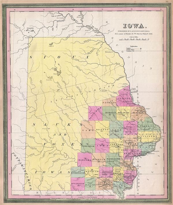
This map was prepared by H.N. Burroughs as plate no. 16 in the 1846 edition of Mitchell's New General Atlas. The map covers all of modern day Iowa though county platting has been limited to the southeastern quadrants. The remainder of the state is devoted primarily to the Sioux and Sac and Fox American Indian Nations. Iowa was admitted to the Union on December 28 of 1846, the same year this map was issued. Around the same time the Sac and Fox largely withdrew from Iowa - a legacy of the 1832 Black Hawk War. The Sioux meanwhile ranged far and wide in northern Iowa, including deep into Sac and Fox territory. The U.S. Government subsequently established a Neutral Ground roughly 40 miles wide and enforced from Fort Atkinson, shown here, as a buffer zone between the two tribes. This map was drawn by H. N Burroughs for the 1846 first edition of Mitchell's New Universal Atlas.
This map was prepared by H.N. Burroughs as plate no. 16 in the 1846 edition of Mitchell's New General Atlas. The map covers all of modern day Iowa though county platting has been limited to the southeastern quadrants. The remainder of the state is devoted primarily to the Sioux and Sac and Fox American Indian Nations. Iowa was admitted to the Union on December 28 of 1846, the same year this map was issued. Around the same time the Sac and Fox largely withdrew from Iowa - a legacy of the 1832 Black Hawk War. The Sioux meanwhile ranged far and wide in northern Iowa, including deep into Sac and Fox territory. The U.S. Government subsequently established a Neutral Ground roughly 40 miles wide and enforced from Fort Atkinson, shown here, as a buffer zone between the two tribes. This map was drawn by H. N Burroughs for the 1846 first edition of Mitchell's New Universal Atlas.
CartographerS
Samuel Augustus Mitchell (March 20, 1792 - December 20, 1868) began his map publishing career in the early 1830s. Mitchell was born in Bristol, Connecticut. He relocated to Philadelphia in 1821. Having worked as a school teacher and a geographical writer, Mitchell was frustrated with the low quality and inaccuracy of school texts of the period. His first maps were an attempt to rectify this problem. In the next 20 years Mitchell would become the most prominent American map publisher of the mid-19th century. Mitchell worked with prominent engravers J. H. Young, H. S. Tanner, and H. N. Burroughs before attaining the full copyright on his maps in 1847. In 1849 Mitchell either partnered with or sold his plates to Thomas, Cowperthwait and Company who continued to publish the Mitchell's Universal Atlas. By about 1856 most of the Mitchell plates and copyrights were acquired by Charles Desilver who continued to publish the maps, many with modified borders and color schemes, until Mitchell's son, Samuel Augustus Mitchell Junior, entered the picture. In 1859, S.A. Mitchell Jr. purchased most of the plates back from Desilver and introduced his own floral motif border. From 1860 on, he published his own editions of the New General Atlas. The younger Mitchell became as prominent as his father, publishing maps and atlases until 1887, when most of the copyrights were again sold and the Mitchell firm closed its doors for the final time. More by this mapmaker...
Horatio Nelson Burroughs (June 28, 1812 - August 23, 1896) was an engraver and later a banker based in Pennsylvania and active in the early 19th century. He was born in Washington Crossing, New Jersey. Burroughs' work first appears in conjunction with Henry Schenk Tanner and Samuel Augustus Mitchell (the elder). His name appears on the 1846 copyrights of many of Mitchell's earliest and most important atlas and pocket maps. Following 1846, Burroughs retired from engraving to become a banker, eventually becoming president of Commonwealth Bank. He married first Eleanor Douglas Mitchell (18?? - 1853), then, after her untimely death, her sister Caroline Mitchell (1818 - 1892), both daughters of map and atlas publisher Samuel Augustus Mitchell Sr. (1792 - 1868). Learn More...
Source
Mitchell, S., A New Universal Atlas Containing Maps of the various Empires, Kingdoms, States and Republics Of The World, 1846.
Condition
Very good. Minor overall toning. Chip upper left margin not intruding on printed area. Blank on verso.
References
Rumsey 0537.035. Philips (Atlases) 6103-35.