1861 Mitchell Map of Iowa and Missouri
IowaMissouri-mitchell-1861$125.00

Title
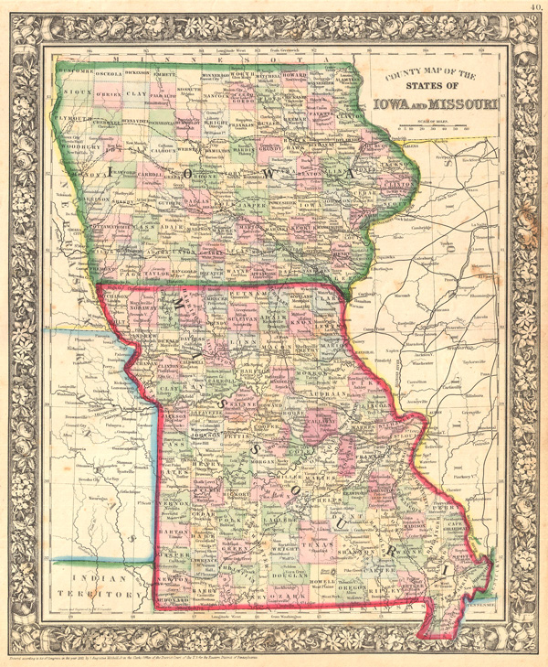
County Map of the States of Iowa and Missouri.
1861 (dated) 14.75 x 12 in (37.465 x 30.48 cm)
1861 (dated) 14.75 x 12 in (37.465 x 30.48 cm)
Description
This beautiful 1861 map of Iowa and Missouri shows cities and towns in considerable detail, and counties differentiated by delicate pastels. Notes important river systems, railways, canals, and cities. Updated from the 1860 variant in 1861 to reflect the rapid settlement of this region by European Americans in the mid-19th century. One of the most attractive American atlas maps of this region to appear in the period. Features the floral border typical of Mitchell maps from the 1860-65 period. Prepared as plate no. 40 in the General Atlasby the legendary American map publisher Samuel Augustus Mitchell Jr. Dated and copyrighted, 'Entered according to Act of Congress in the Year 1861 by S. Augustus Mitchell in the Clerk's Office of the District Court of the U.S. for the Eastern District of Pennsylvania.'
Cartographer
Samuel Augustus Mitchell (March 20, 1792 - December 20, 1868) began his map publishing career in the early 1830s. Mitchell was born in Bristol, Connecticut. He relocated to Philadelphia in 1821. Having worked as a school teacher and a geographical writer, Mitchell was frustrated with the low quality and inaccuracy of school texts of the period. His first maps were an attempt to rectify this problem. In the next 20 years Mitchell would become the most prominent American map publisher of the mid-19th century. Mitchell worked with prominent engravers J. H. Young, H. S. Tanner, and H. N. Burroughs before attaining the full copyright on his maps in 1847. In 1849 Mitchell either partnered with or sold his plates to Thomas, Cowperthwait and Company who continued to publish the Mitchell's Universal Atlas. By about 1856 most of the Mitchell plates and copyrights were acquired by Charles Desilver who continued to publish the maps, many with modified borders and color schemes, until Mitchell's son, Samuel Augustus Mitchell Junior, entered the picture. In 1859, S.A. Mitchell Jr. purchased most of the plates back from Desilver and introduced his own floral motif border. From 1860 on, he published his own editions of the New General Atlas. The younger Mitchell became as prominent as his father, publishing maps and atlases until 1887, when most of the copyrights were again sold and the Mitchell firm closed its doors for the final time. More by this mapmaker...
Source
Mitchell Jr., S. A., Mitchell's New General Atlas, 1861.
Condition
Very Good. Even overall toning.
References
Rumsey 2483.032 (1870 edition). Phillips (Atlases) 831-75. New York Public Library, Map Division, 1510817.