This item has been sold, but you can get on the Waitlist to be notified if another example becomes available, or purchase a digital scan.
1853 Black Map of Ireland
Ireland-black-1853$87.50

Title
Ireland.
1853 (undated) 14.5 x 10.25 in (36.83 x 26.035 cm) 1 : 1550000
1853 (undated) 14.5 x 10.25 in (36.83 x 26.035 cm) 1 : 1550000
Description
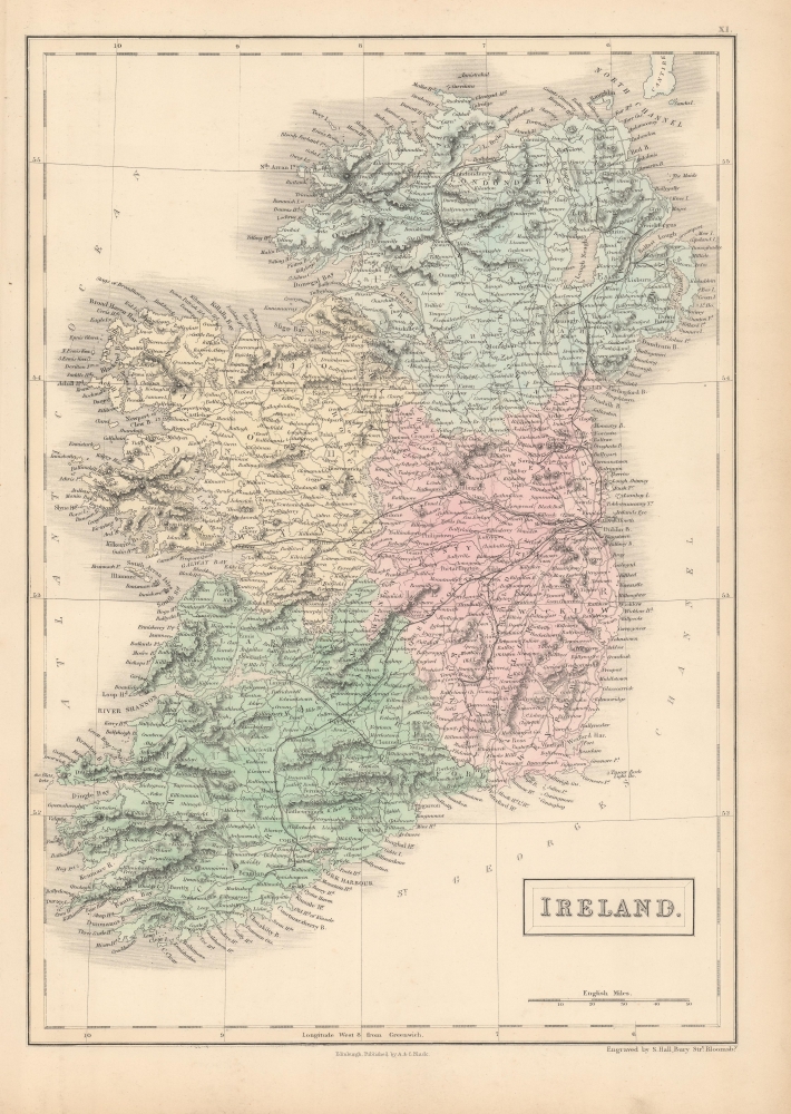
A fine example of Charles and Adam Black's 1853 map of Ireland, engraved by Sidney Hall and published in Black's General Atlas of the World.
Following a failed uprising in 1798, Ireland became part of the United Kingdom of Great Britain and Ireland in 1801. Though Britain flourished during this period, Ireland suffered a series of famines, the worst one being the Great Irish Famine, which lasted from 1845 - 1849 and killed about a million people. Anti-British and Republican agitation resulted in repeated uprisings, whose surviving participants were shipped off to Van Diemen's Land and other penal colonies, along with debtors and non-political convicts. As a result, Ireland experienced a widespread exodus, both involuntary and voluntary migration, the latter mostly to the United States. By the end of the 19th century, almost 50 percent of immigrants into the United States were from Ireland.
A Closer Look
Coverage includes Ireland and nearby coastal islands, with towns, cities, roads, railways, and rivers illustrated and labeled, with mountains and several other topographical details noted and relief rendered by hachure. Provinces (Leinster, Ulster, Munster, and Connaught) are labeled and denoted with color shading, while counties are recorded with black text. A notable feature compared to the corresponding map of Ireland in earlier editions of Black's General Atlas is the addition of railways, including those linking Dublin with Belfast, Galway, and Tipperary, from which Limerick and Cork could be reached. Railways significantly reduced demand for canals which had been built in the late 18th century, including the Royal Canal and Grand Canal, seen here also emanating from Dublin.19th Century Irish History
English rule in Ireland began with the Norman invasions of the late 12th century, but the authority of the Crown was partial and had virtually disappeared by the early 16th century. Afterwards, a series of monarchs beginning with Henry VIII sought to reassert English control of Ireland, leading to bloody wars and uprisings, including spillover from the English Civil War, which led to an especially bloody campaign by Oliver Cromwell to subdue the island. Through the 17th century, discrimination against Catholics, famines, and mistreatment by landlords continued to roil tensions, while a portion of the elite came to identify with Ireland more than England. By the end of the 18th century, support for Irish Republicanism grew substantially, inspired by the American and French revolutions.Following a failed uprising in 1798, Ireland became part of the United Kingdom of Great Britain and Ireland in 1801. Though Britain flourished during this period, Ireland suffered a series of famines, the worst one being the Great Irish Famine, which lasted from 1845 - 1849 and killed about a million people. Anti-British and Republican agitation resulted in repeated uprisings, whose surviving participants were shipped off to Van Diemen's Land and other penal colonies, along with debtors and non-political convicts. As a result, Ireland experienced a widespread exodus, both involuntary and voluntary migration, the latter mostly to the United States. By the end of the 19th century, almost 50 percent of immigrants into the United States were from Ireland.
Publication History
This map was engraved by Sidney Hall for publication the 1853 edition of Black's General Atlas of the World.CartographerS
Charles and Adam Black (fl. 1807 - present) were map and book publishers based in Edinburgh. Charles and his uncle, Adam, both of Edinburgh, Scotland, founded their publishing firm in 1807. They published a series of maps and atlases throughout the 19th century. In addition to an array of atlases, the Black firm is known for their editions of the Encyclopedia Britannica (1817 - 1826) and the first publishing of Sir Walter Scott's novels in 1854. In 1889 the A. & C. Black publishing house moved to London where it remains in operation to this day. More by this mapmaker...
Sidney Hall (1788 - 1831) was an English engraver and map publisher active in London during the late 18th and early 19th centuries. His earliest imprints, dating to about 1814, suggest a partnership with Michael Thomson, another prominent English map engraver. Hall engraved for most of the prominent London map publishers of his day, including Aaron Arrowsmith, William Faden, William Harwood, and John Thomson, among others. Hall is credited as being one of the earliest adopters of steel plate engraving, a technique that allowed for finer detail and larger print runs due to the exceptional hardness of the medium. Upon his early death - he was only in his 40s - Hall's business was inherited by his wife, Selina Hall, who continued to publish under the imprint, "S. Hall", presumably for continuity. The business eventually passed to Sidney and Selina's nephew Edward Weller, who became extremely prominent in his own right. Learn More...
Source
Hall, S. and W. Hughes, Black's General Atlas: Comprehending Seventy-Two Maps. Engraved on Steel, in the First Style of Art, By Sidney Hall, William Hughes, F.R.G.S., etc. New Edition., (Edinburgh: Adam and Charles Black) 1853.
Black's General Atlas was a popular Scottish atlas of the world issued by the Edinburgh firm of Adam and Charles Black. This atlas was first issued in 1840 with subsequent editions being printed well into the 1890s. While most editions were printed in Edinburgh, an American edition was issued in 1857. Most early editions of his atlas were engraved by S. Hall. Typically this refers to Sidney Hall, who died in 1831, but in this case, since the engraving was initiated well after his death, it was most likely his widow, Selina Hall, who did the engraving. Later editions feature additional maps updated and engraved by William Hughes. Early editions featured outline color only, but later editions embraced a full color approach with pale green, yellow, and blue pastels. All editions are known for their meticulous presentation of the most up-to-date cartographic information. Moreover, this exceptionally long publication run provides a fine cartographic record of the middle to late 19th century - particularly as regards the complex cartographic evolution of the Americas through this period.
Condition
Very good.
References
Rumsey 2305.020 (1854 edition). Philips (atlases) 4334.