This item has been sold, but you can get on the Waitlist to be notified if another example becomes available, or purchase a digital scan.
1850 Cruchley Map of Ireland
Ireland-cruchley-1850$75.00

Title
Ireland.
1850 (dated) 18 x 15 in (45.72 x 38.1 cm) 1 : 1070000
1850 (dated) 18 x 15 in (45.72 x 38.1 cm) 1 : 1070000
Description
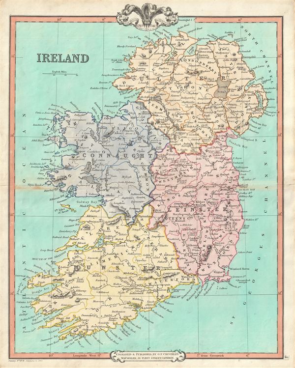
A lovely 1850 map of Ireland by George Frederick Cruchley. The map covers the the entirity of Irealand and is divided four provinces: Ulster, Connaught, Leinster and Munster. Tuscan Rock, near the southeast coast of Ireland, known to have destroyed more ships than any other Irish coastal feature, is identified. Cruchley's map is color coded according to provinces and identifies important towns, cities, rivers, mountains and an assortment of other topographical features. Relief is rendered by hachure.
After the Norman Invasion, the old provincial structure was supplemented with modern system of counties – even so, the old provinces are still referenced today. In 1801, the island of Ireland became part of the United Kingdom of Great Britain and Ireland. Though Britain flourished during the 19th century, Ireland suffered a series of famines, the worst being the Great Irish Famine, which lasted from 1845 – 1849 and killed about a million people. As a result Ireland experienced a widespread exodus – mostly to the United States. By the end of the 19th century, almost 50% of immigrants into the United States were from Ireland.
Cruchley's General Atlas was unique for its period, employing a vivid color scheme extending even to the oceans, distinctive typography, and various uncommon decorative elements including a peacock feather crown and an imprint medallion, both of which break the printed border. Though many of the maps in this atlas are copyrighted in 1841, the atlas was first published in 1843 from the Cruchley office at 81 Fleet Street, London, and proving popular went through numerous reissues well into the 1850s.
Cartographer
George Frederick Cruchley (April 23, 1797 - June 16, 1880) was a London based book and map seller active in the middle part of the 19th century. Cruchley began his cartographic career as an apprentice at the venerable Aaroon Arrowsmith firm. Many of Cruchley's earliest maps bear the words 'From Arrowsmith's' on the imprint. In 1844, Cruchley acquired the massive stock of the important early 19th century firm of John Cary. Cruchley published his own maps as well as reissues of Cary's stock well into the 1870s. He is best known for his detailed plans of London, which in recent years have become increasingly scarce and desirable. Cruchley was based in London on 38 Ludgate Street until 1834 when he moved his offices to 81 Fleet Street. Shortly before his death in 1880 Cruchely auctioned (Hodgson's Auctions, Jan 16, 1877) his entire stock. Many of his map plates were thusly acquired by 'Gall and Inglis' who continued the Cruchley tradition well into the early 20th century. Cruchley's son, also George Frederick (1837 - 1882), continued to work as a book and map seller until his death. More by this mapmaker...
Source
Cruchley, G. F., Selection of Maps from Cruchley's General Atlas, for the use of Schools and Private Tuition, London, 1850.
Condition
Very good. Minor wear and some toning over original centerfold. Blank on verso.