
This item below is out of stock, but another example (left) is available. To view the available item, click "Details."
Details
1862 British Admiralty Nautical Map of Ireland from Dublin to Wicklow
1862 (dated) $250.00
1845 Ewing Map of Ireland
Ireland-ewing-1845$50.00

Title
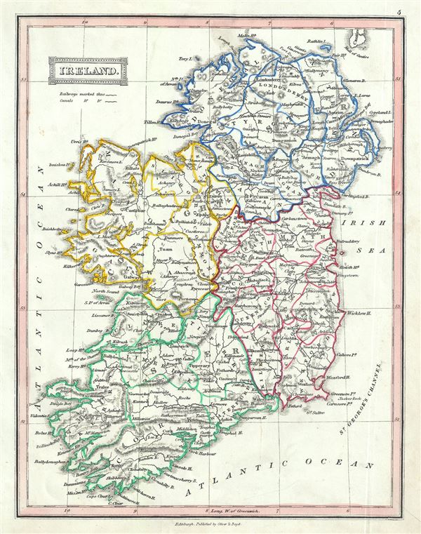
Ireland.
1845 (undated) 10.5 x 8.5 in (26.67 x 21.59 cm) 1 : 1900000
1845 (undated) 10.5 x 8.5 in (26.67 x 21.59 cm) 1 : 1900000
Description
This is a beautiful example of Thomas Ewing's 1845 map of Ireland. The map shows all of Ireland from Donegal in the north to Cork in the south. After the Norman Invasion the old provincial structure was supplemented with modern system of counties â€' even so the old provinces are still referenced today. Ewing's map depicts the provinces of Leister, Ulster, Munster and Connacht and identifies important towns, cities, rivers, mountains and an assortment of other topographical features. Relief is rendered by hachure.
In 1801, the island of Ireland became part of the United Kingdom of Great Britain and Ireland. Though Britain flourished during this period, Ireland would witness the Great Irish Famine from 1845-1849 causing mass starvation and emigration and killing about a million people. As a result, Ireland would experience a widespread exodus â€' mostly to the United States. By the end of the 19th century, almost 50% of immigrants into the United States would be from Ireland. This map was published in 1845 by Oliver and Boyd as part of Ewing's New General Atlas.
In 1801, the island of Ireland became part of the United Kingdom of Great Britain and Ireland. Though Britain flourished during this period, Ireland would witness the Great Irish Famine from 1845-1849 causing mass starvation and emigration and killing about a million people. As a result, Ireland would experience a widespread exodus â€' mostly to the United States. By the end of the 19th century, almost 50% of immigrants into the United States would be from Ireland. This map was published in 1845 by Oliver and Boyd as part of Ewing's New General Atlas.
Source
Oliver and Boyd, Ewing's New General Atlas: containing Distinct Maps of all the Principal States and Kingdoms throughout the World, (Edinburgh) 1845.
Condition
Very good. Minor foxing at places. Blank on verso.