1595 Mercator Map of Ireland
Ireland-mercator-1595-2$1,750.00
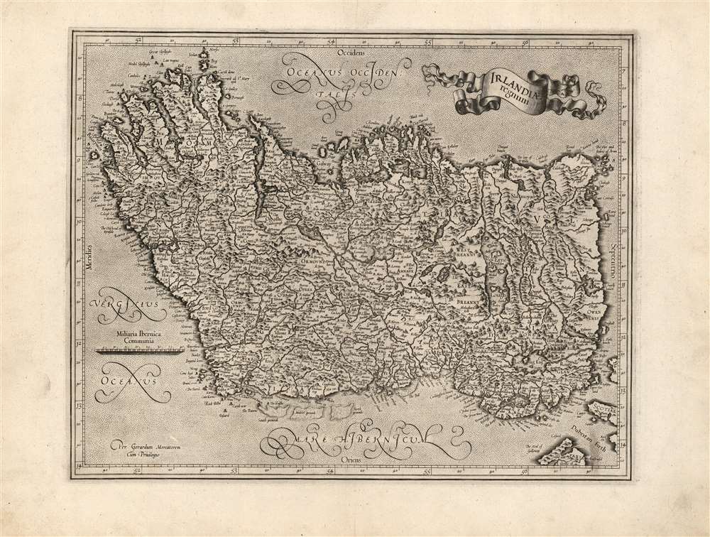

Title
Irlandia regnum.
1595 (undated) 13 x 16.5 in (33.02 x 41.91 cm) 1 : 2500000
1595 (undated) 13 x 16.5 in (33.02 x 41.91 cm) 1 : 2500000
Description
This is a superb, 1595 first atlas edition of Gerard Mercator's map of Ireland. It is one of the earliest maps of Ireland, the second to appear in an atlas, and the first produced by Mercator. Oriented to the west, the map covers the Emerald Isle in detail, noting towns, rivers, lakes, forests, mountains, and a host of additional topographic features. Mountains and forests are beautifully rendered in profile. The map divides Ireland into the four provinces of Ulster, Connaught, Leinster, and Munster.
The Predominant View of Ireland of the Early 17th Century
Mercator had addressed the geography of Ireland previously, in his 1564 wall map of the British Isles. His delineation of Ireland in that map was influential, to the extent that Ortelius reproduced it faithfully in his 1573 map of Ireland. By the time Mercator produced this map, however, he had clearly moved beyond his earlier work. A cursory comparison of the Ireland of the 1564 map and this work shows drastic differences throughout. The level of detail exhibited, along with the ubiquity of Irish place names, suggests that Mercator had encountered detailed surveys, executed in Ireland, by an Irish or English mapmaker. A convincing candidate is the surveyor Robert Lythe, whose surveys added over three thousand Irish place names to the historical record during his 1567-1571 tenure as military engineer under Sir Henry Sidney, the Queen's deputy. J. H. Andrews, in his 1992 address to the 24th Annual Name Study Conference in Belfast, identifies Mercator's maps among those 'based wholly or largely' on Lythe's surveys. Over ninety percent of Lythe's place names recorded on his surveys were at least attempts at the original Irish names, rather than English replacements; thus the present work represents a remarkable glimpse of Irish toponymy of the 16th century. The resultant geography remained state of the art well into the 17th century - both maps independently derived from Leith's surveys, or maps directly cribbed from Mercator's.Publication History and Census
Mercator himself engraved this map for inclusion in Atlas, although he would not live to see it published as this first edition appeared a year after his death. The plates were later purchased by Jodocus Hondius, who continued to use them as the basis for his own atlases, gradually adding additional plates. The map remained in the Hondius / Jansson atlases unchanged until 1636, at which point Mercator's name was removed. Shortly thereafter, Jansson replaced the map with an entirely new work. This present map is an example of the first state and conforms typographically with examples of the 1595 first Latin edition of Mercator's Atlas. In various editions, examples appear on the market from time to time and the map is reasonably well represented in institutional collections.Cartographer
Gerard Mercator (March 5, 1512 - December 2, 1594) is a seminal figure in the history of cartography. Mercator was born near Antwerp as Gerard de Cremere in Rupelmonde. He studied Latin, mathematics, and religion in Rupelmonde before his Uncle, Gisbert, a priest, arranged for him to be sent to Hertogenbosch to study under the Brothers of the Common Life. There he was taught by the celebrated Dutch humanist Georgius Macropedius (Joris van Lanckvelt; April 1487 - July 1558). It was there that he changed him name, adapting the Latin term for 'Merchant', that is 'Mercator'. He went on to study at the University of Louvain. After some time, he left Louvain to travel extensively, but returned in 1534 to study mathematics under Gemma Frisius (1508 - 1555). He produced his first world map in 1538 - notable as being the first to represent North America stretching from the Arctic to the southern polar regions. This impressive work earned him the patronage of the Emperor Charles V, for whom along with Van der Heyden and Gemma Frisius, he constructed a terrestrial globe. He then produced an important 1541 globe - the first to offer rhumb lines. Despite growing fame and imperial patronage, Mercator was accused of heresy and in 1552. His accusations were partially due to his Protestant faith, and partly due to his travels, which aroused suspicion. After being released from prison with the support of the University of Louvain, he resumed his cartographic work. It was during this period that he became a close fried to English polymath John Dee (1527 - 1609), who arrived in Louvain in 1548, and with whom Mercator maintained a lifelong correspondence. In 1552, Mercator set himself up as a cartographer in Duisburg and began work on his revised edition of Ptolemy's Geographia. He also taught mathematics in Duisburg from 1559 to 1562. In 1564, he became the Court Cosmographer to Duke Wilhelm of Cleve. During this period, he began to perfect the novel projection for which he is best remembered. The 'Mercator Projection' was first used in 1569 for a massive world map on 18 sheets. On May 5, 1590 Mercator had a stroke which left him paralyzed on his left side. He slowly recovered but suffered frustration at his inability to continue making maps. By 1592, he recovered enough that he was able to work again but by that time he was losing his vision. He had a second stroke near the end of 1593, after which he briefly lost speech. He recovered some power of speech before a third stroke marked his end. Following Mercator's death his descendants, particularly his youngest son Rumold (1541 - December 31, 1599) completed many of his maps and in 1595, published his Atlas. Nonetheless, lacking their father's drive and genius, the firm but languished under heavy competition from Abraham Ortelius. It was not until Mercator's plates were purchased and republished (Mercator / Hondius) by Henricus Hondius II (1597 - 1651) and Jan Jansson (1588 - 1664) that his position as the preeminent cartographer of the age was re-established. More by this mapmaker...
Source
Mercator, G., Atlas sive Cosmographicae, (Amsterdam) 1595.
Mercator's Atlas is one of the most important works in the history of cartography. Although in fact Ortelius was the first to publish a proper atlas, the Teatrum Orbis Terrarum, Mercator's work the first book to employ the term Atlas for a collection of maps. The term is derived both from the mythical titan, Atlas, who was forced to bear the world upon his shoulders, and the Libyan king, philosopher, and astronomer of the same name that, so the legend goes, constructed the first globe. Mercator dedicated the final 25 years of his life to compile the Atlas. He published two parts during his lifetime in 1585 and 1589, but the final part published posthumously by his son Rumold Mercator, in 1595. The map plates for the Atlas were later acquired by Jodocus Hondius who published the most complete and well known edition in 1606. It was Jodocus who popularized the Atlas and who did the most to elevate Gerard Mercator's name.
Condition
Excellent. Light marginal soiling, else a fine example with an uncommonly sharp strike.
References
OCLC 635194898. Law, B., The printed maps of Ireland to 1612, p.19-20.