This item has been sold, but you can get on the Waitlist to be notified if another example becomes available, or purchase a digital scan.
1850 Mitchell Map of Ireland
Ireland-mitchell-1850$100.00

Title
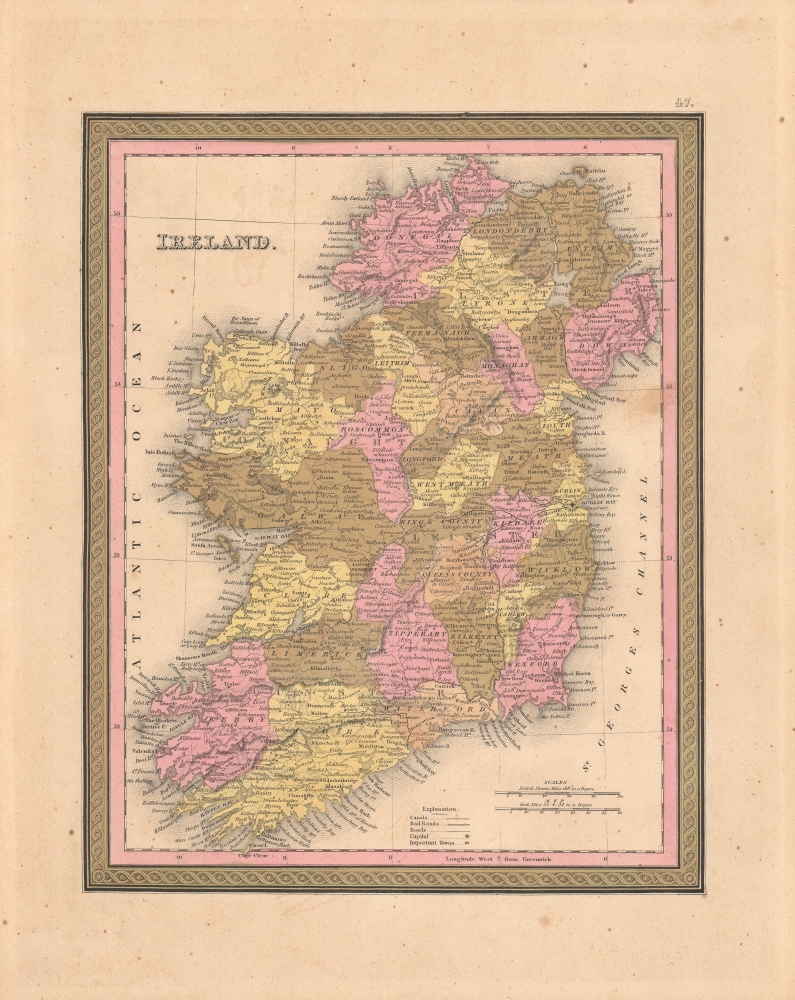
Ireland.
1850 (undated) 13 x 10 in (33.02 x 25.4 cm) 1 : 1600000
1850 (undated) 13 x 10 in (33.02 x 25.4 cm) 1 : 1600000
Description
This hand-colored map is a lithographic map of Ireland, dating to 1850, by the American mapmaker S. A. Mitchell and publishers Thomas, Cowperthwait, and Co. The map illustrates Ireland shortly after the Great Famine (1845 - 1849) and at the peak of Irish immigration to the United States.
A Closer Look
Coverage embraces Ireland and surrounding waters. Ireland is divided into 32 counties. Topography is clearly presented and towns, lakes, roads, and other information are present. Political divisions are indicated with contrasting pastels. The whole is engraved and colored in Mitchell's distinctive style with green border work and vivid pastels.Historical Context
In 1850, Ireland was undergoing a period of profound transformation and hardship, still reeling from the devastating effects of the Great Famine (1845 - 1849). This catastrophic event, caused primarily by a potato blight, led to the death of approximately one million people and forced another million to emigrate, significantly reducing the island's population. The famine had far-reaching impacts on Ireland's social, economic, and political landscape. Rural areas, where the population was heavily dependent on agriculture, particularly the potato crop, were the most affected. The post-famine period saw continued emigration, particularly to the United States, and a shift in demographic and economic patterns. The British government's response to the famine had been widely criticized, exacerbating political tensions and contributing to the growth of Irish nationalism.Publication History and Census
This map was issued for the 1850 edition of the New Universal Atlas. It was the first edition of that atlas to be published after Mitchell sold his plates and rights to Thomas, Cowperthwait, and Company in 1850.CartographerS
Samuel Augustus Mitchell (March 20, 1792 - December 20, 1868) began his map publishing career in the early 1830s. Mitchell was born in Bristol, Connecticut. He relocated to Philadelphia in 1821. Having worked as a school teacher and a geographical writer, Mitchell was frustrated with the low quality and inaccuracy of school texts of the period. His first maps were an attempt to rectify this problem. In the next 20 years Mitchell would become the most prominent American map publisher of the mid-19th century. Mitchell worked with prominent engravers J. H. Young, H. S. Tanner, and H. N. Burroughs before attaining the full copyright on his maps in 1847. In 1849 Mitchell either partnered with or sold his plates to Thomas, Cowperthwait and Company who continued to publish the Mitchell's Universal Atlas. By about 1856 most of the Mitchell plates and copyrights were acquired by Charles Desilver who continued to publish the maps, many with modified borders and color schemes, until Mitchell's son, Samuel Augustus Mitchell Junior, entered the picture. In 1859, S.A. Mitchell Jr. purchased most of the plates back from Desilver and introduced his own floral motif border. From 1860 on, he published his own editions of the New General Atlas. The younger Mitchell became as prominent as his father, publishing maps and atlases until 1887, when most of the copyrights were again sold and the Mitchell firm closed its doors for the final time. More by this mapmaker...
Joseph Baker Cowperthwait (October 15, 1833 - November 26, 1891) was an American book and map publisher. Born in Philadelphia, Cowperthwait became a successful map publisher, taking over the Samuel Augustus Mitchell Sr. (1792 - 1868) maps, atlases, and plates in 1850. His father, Hulings Cowperthwait (1802 -1873), began the publishing business, and was part of a few publishing firms, including Thomas, Cowperthwait, and Company and Cowperthwait, Desilver, and Butler. Cowperthwait, Desilver, and Butler dissolved in 1855 and H. Cowperthwait, Joseph B. Cowperthwait, D. M. Warren, George Pancoast, and Theodore H. Butler together formed H. Cowperthwait and Co. Cowperthwait died on Thanksgiving Day, 1891. Learn More...
Source
Mitchell, S. A., A New Universal Atlas, (Philadelphia: Thomas, Cowperthwait and Co.) 1850.
The New Universal Atlas is one of the great American atlases of the mid-19th century. Samuel Augustus Mitchell first issued the atlas in 1846 when he acquired the map plates and copyright for Tanner's New Universal Atlas from its publisher, Carey and Hart. The first transitional 1846 edition was published jointly with Carey and Hart, but a second edition was published in the same year with the Tanner imprint erased. This edition of the atlas also introduced the signature S. A. Mitchell green and pink color scheme. Most of the maps from the early editions of the atlas were engraved by H. N. Burroughs or C. S. Williams, often bearing their copyright. Burroughs maps also tended to have what map collector David Rumsey refers to as the 'Cary and Hart' borders, which featured a narrow vine motif. These borders were replaced, along with the Burroughs imprint, with the more traditional Mitchell strap work border used in the atlases until 1856. Mitchell published editions until late in 1850, when he sold the rights to Thomas, Cowperthwait and Company of Philadelphia. Under Cowperthwait, the atlases continued to be published and bear the Mitchell name until 1856, when the plates were again sold, this time to Charles Desilver. Desilver reworked the plates with new border art and a revised color scheme in the style of J. H. Colton. Desilver issued editions from 1857 to 1860, when the atlas was phased out in favor of Samuel Augustus Mitchell Jr.'s New General Atlas.
Condition
Very good. Minor foxing and overall toning. Minor discoloration just east of Louth, near margin.
References
Rumsey 0545.051.