This item has been sold, but you can get on the Waitlist to be notified if another example becomes available, or purchase a digital scan.
1817 Thomson Map of Ireland (set of 2 maps)
Ireland-thomson-1817$250.00

Title
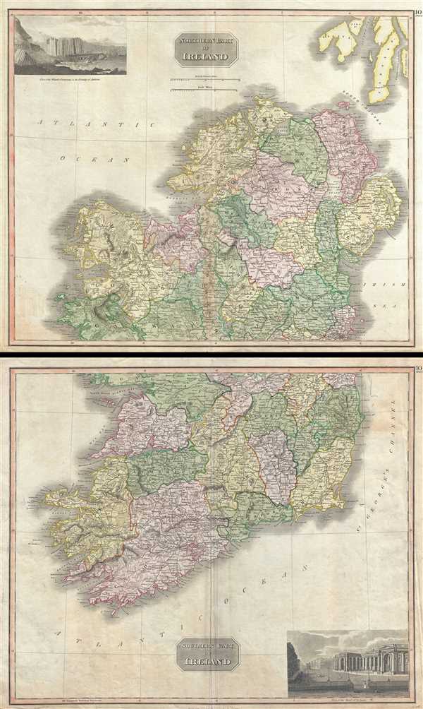
Northern Part of Ireland. Southern Part of Ireland.
1817 (undated) 40 x 24.5 in (101.6 x 62.23 cm) 1 : 650000
1817 (undated) 40 x 24.5 in (101.6 x 62.23 cm) 1 : 650000
Description
This is an attractive set of the 1817 maps of Ireland by John Thomson. Essentially two separate maps, the first map (image top) depicts Northern Ireland while the lower map depicts the Southern portions of Ireland. The whole is beautifully engraved in the minimalist English style pioneered in the London and Edinburgh during early part of the 19th century. Together, the maps depict the entire Emerald Isle, divided into 32 counties, covering from Donegal in the north to Cork in the south. Towns, rivers, mountains, railroads, and various other important topographical details are noted. Elevation throughout is rendered by hachure and political and territorial boundaries are outlined in color.
In 1801, the island of Ireland became part of the United Kingdom of Great Britain and Ireland. Though Britain flourished during the 19th century, Ireland suffered a series of famines, the worst being the Great Irish Famine, which lasted from 1845 - 1849 and killed about a million people. As a result Ireland experienced a widespread exodus - mostly to the United States. By the end of the 19th century, almost 50% of immigrants into the United States hailed from Ireland. Overall, a beautiful set prepared by John Thomson for inclusion in the 1817 edition of Thomson's New General Atlas. Note: The image above represents two separate sheets.
In 1801, the island of Ireland became part of the United Kingdom of Great Britain and Ireland. Though Britain flourished during the 19th century, Ireland suffered a series of famines, the worst being the Great Irish Famine, which lasted from 1845 - 1849 and killed about a million people. As a result Ireland experienced a widespread exodus - mostly to the United States. By the end of the 19th century, almost 50% of immigrants into the United States hailed from Ireland. Overall, a beautiful set prepared by John Thomson for inclusion in the 1817 edition of Thomson's New General Atlas. Note: The image above represents two separate sheets.
Cartographer
John Thomson (1777 - c. 1841) was a Scottish cartographer, publisher, and bookbinder active in Edinburgh during the early part of the 19th century. Thomson apprenticed under Edinburgh bookbinder Robert Alison. After his apprenticeship, he briefly went into business with Abraham Thomson. Later, the two parted ways, John Thomson segueing into maps and Abraham Thomson taking over the bookbinding portion of the business. Thomson is generally one of the leading publishers in the Edinburgh school of cartography, which flourished from roughly 1800 to 1830. Thomson and his contemporaries (Pinkerton and Cary) redefined European cartography by abandoning typical 18th-century decorative elements such as elaborate title cartouches and fantastic beasts in favor of detail and accuracy. Thomson's principle works include Thomson's New General Atlas, published from 1814 to 1821, the New Classical and Historical Atlas of 1829, and his 1830 Atlas of Scotland. The Atlas of Scotland, a work of groundbreaking detail and dedication, would eventually bankrupt the Thomson firm in 1830, at which time their plates were sequestered by the court. The firm partially recovered in the subsequent year, allowing Thomson to reclaim his printing plates in 1831, but filed again for bankruptcy in 1835, at which time most of his printing plates were sold to A. K. Johnston and Company. There is some suggestion that he continued to work as a bookbinder until 1841. Today, Thomson maps are becoming increasingly rare as they are highly admired for their impressive size, vivid hand coloration, and superb detail. More by this mapmaker...
Source
Thomson, J., A New General Atlas, (Edinburgh) 1817.
Thomson's New General Atlas was first published in 1817 and continued to be published until about 1821. This is the first of Thomson's major cartographic works and the atlas for which is most celebrated. The New General Atlas follows in the Edinburgh School, which eschews excessive decoration in favor of a more minimalistic fact-based cartographic vision, as established by John Pinkerton, Laurie and Whittle, John Cary, and others in the previous decades. The maps are notable for their massive scale, heavy stock, elegant color work, and easy-to-read typefaces. Although the atlas stopped being published after 1821, Thomson continued to offer 'supplementary' maps that could be tipped into the atlas as late as 1830, when he declared bankruptcy. The maps in the Thomson Atlas were engraved by Thomas Clerk, William Dassauville, Nathaniel Rogers Hewitt, James Kirkwood, Robert Kirkwood, John Menzies, George Menzies, Edward Mitchell, John Moffatt, Samuel John Neele, Robert Scott, and James Wyld.
Condition
Very good. Set of two maps. Minor wear and verso repair along original centerfolds. Original platemarks visible. Foxing and toning at places.