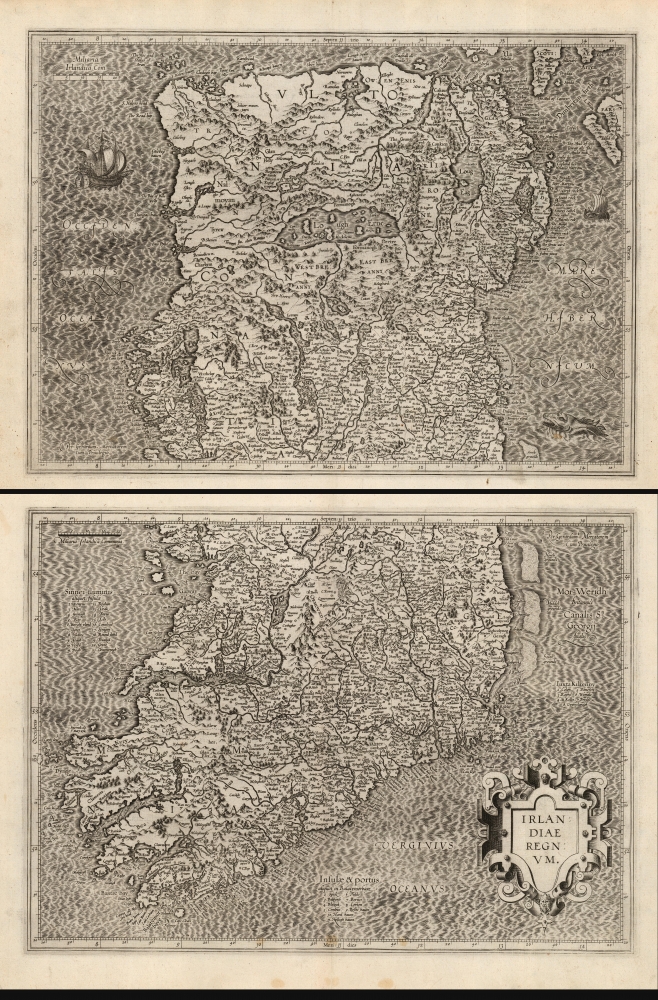
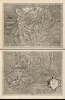
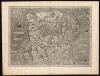
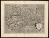
1595 Mercator's Two-Sheet Map of Ireland
Irelandiae-mercator-1595$2,500.00


Title
Irlandiae regnum.
1595 (undated) 26.75 x 18.5 in (67.945 x 46.99 cm) 1 : 634000
1595 (undated) 26.75 x 18.5 in (67.945 x 46.99 cm) 1 : 634000
Description
This is a superb, 1595 first atlas edition of Gerard Mercator's two-sheet map of Ireland. It is the most detailed of the early atlas maps of Ireland, and one of the earliest printed maps to be substantially based on actual surveys - to wit, the surveys of Robert Leith.
A Closer Look
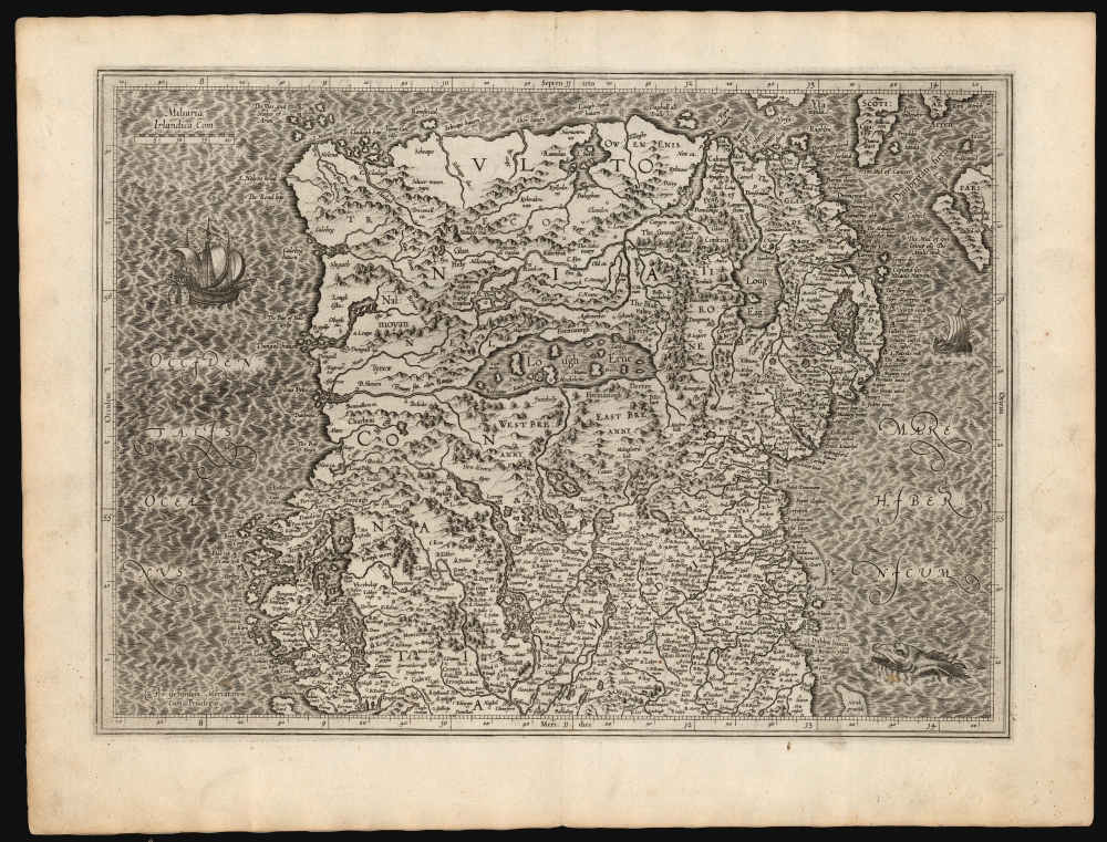
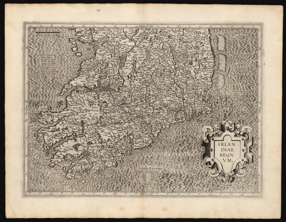
The map is on two sheets included consecutively in Mercator's atlas. Both maps are oriented to the north and overlap slightly in coverage. The untitled first sheet extends from Galway in the south to embrace points north, including part of Scotland and the Isle of Islay. The second sheet spans from the southern point of Dublin Harbor to the southern part of Ireland. Both sheets exhibit Mercator's superb engraving - the elegantly hachured waves of the north sheet are patrolled by two ships and prowled by a sea monster, while the bottom corners of the south sheet are embellished with a superb strapwork cartouche. Mountains and forests on both sheets are indicated pictorially. As ever, Mercator's meticulous Italic lettering affords the legible inclusion of a host of placenames - crucial with this map, as it is the earliest acquirable, detailed map of Ireland derived from Leith's surveys, which contributed over three thousand Irish placenames to the geographical lexicon.A Revolution in Irish Mapmaking
Mercator had addressed the geography of Ireland previously, in his 1564 wall map of the British Isles, probably derived from the maps of Laurence Nowell. Mercator's delineation of Ireland in that map was influential as Ortelius reproduced it faithfully in his 1573 map of Ireland. Nonetheless, by the time Mercator produced the present map, he had moved beyond his earlier work. A cursory comparison of the hist 1564 Ireland and this map reveals drastic differences. The level of detail, along with the ubiquity of Irish place names, suggests access to detailed surveys, executed in Ireland, by an Irish or English mapmaker. A convincing candidate is Robert Lythe, whose 1567-1571 tenure as military engineer under Sir Henry Sidney, the Queen's deputy added over three thousand Irish place names to the historical record. During this period, Lythe surveyed the east and south coasts from Carrickfergus to Sheep's Head, followed by surveys of the interior and west coast as far as the southern Connaught. The regions of Ulster and north Connaught proved too dangerous for Leith. Consequently, these areas are much distorted on the present map and show scant place names. This part of the map relies heavily on Mercator's 1564 work. J. H. Andrews, in his 1992 address to the 24th Annual Name Study Conference in Belfast, identifies Mercator's maps among those 'based wholly or largely' on Lythe's surveys. Over 90% of Lythe's place names were at least attempts at the original Irish names, rather than English replacements; thus the present work represents a remarkable glimpse of Irish toponymy of the 16th century. The resultant geography remained state of the art well into the 17th century.Publication History and Census
Mercator himself engraved these plates for inclusion in his Atlas, although he would not live to see them published as this first edition appeared a year after his death. The plates were later purchased by Jodocus Hondius, who continued to use them as the basis for his own atlases, gradually adding additional plates. They remained in the Hondius / Jansson atlases unchanged until 1636, at which point Mercator's imprint was removed. Shortly thereafter, Jansson replaced these maps with entirely new work. The present sheets are examples of the first state, conforming typographically with examples of the 1595 first Latin edition of Mercator's Atlas. In various editions, examples appear on the market from time to time and they are reasonably well represented in institutional collections. Confirmed examples of this first issue are scarce.CartographerS
Gerard Mercator (March 5, 1512 - December 2, 1594) is a seminal figure in the history of cartography. Mercator was born near Antwerp as Gerard de Cremere in Rupelmonde. He studied Latin, mathematics, and religion in Rupelmonde before his Uncle, Gisbert, a priest, arranged for him to be sent to Hertogenbosch to study under the Brothers of the Common Life. There he was taught by the celebrated Dutch humanist Georgius Macropedius (Joris van Lanckvelt; April 1487 - July 1558). It was there that he changed him name, adapting the Latin term for 'Merchant', that is 'Mercator'. He went on to study at the University of Louvain. After some time, he left Louvain to travel extensively, but returned in 1534 to study mathematics under Gemma Frisius (1508 - 1555). He produced his first world map in 1538 - notable as being the first to represent North America stretching from the Arctic to the southern polar regions. This impressive work earned him the patronage of the Emperor Charles V, for whom along with Van der Heyden and Gemma Frisius, he constructed a terrestrial globe. He then produced an important 1541 globe - the first to offer rhumb lines. Despite growing fame and imperial patronage, Mercator was accused of heresy and in 1552. His accusations were partially due to his Protestant faith, and partly due to his travels, which aroused suspicion. After being released from prison with the support of the University of Louvain, he resumed his cartographic work. It was during this period that he became a close fried to English polymath John Dee (1527 - 1609), who arrived in Louvain in 1548, and with whom Mercator maintained a lifelong correspondence. In 1552, Mercator set himself up as a cartographer in Duisburg and began work on his revised edition of Ptolemy's Geographia. He also taught mathematics in Duisburg from 1559 to 1562. In 1564, he became the Court Cosmographer to Duke Wilhelm of Cleve. During this period, he began to perfect the novel projection for which he is best remembered. The 'Mercator Projection' was first used in 1569 for a massive world map on 18 sheets. On May 5, 1590 Mercator had a stroke which left him paralyzed on his left side. He slowly recovered but suffered frustration at his inability to continue making maps. By 1592, he recovered enough that he was able to work again but by that time he was losing his vision. He had a second stroke near the end of 1593, after which he briefly lost speech. He recovered some power of speech before a third stroke marked his end. Following Mercator's death his descendants, particularly his youngest son Rumold (1541 - December 31, 1599) completed many of his maps and in 1595, published his Atlas. Nonetheless, lacking their father's drive and genius, the firm but languished under heavy competition from Abraham Ortelius. It was not until Mercator's plates were purchased and republished (Mercator / Hondius) by Henricus Hondius II (1597 - 1651) and Jan Jansson (1588 - 1664) that his position as the preeminent cartographer of the age was re-established. More by this mapmaker...
Robert Lythe (fl. 1556-1571) was an English surveyor and mapmaker. Nothing is known of his early life. Although he appears to have specialized as a military surveyor, he was sufficiently broadly educated to be able to make references to hydrography, land quality, natural curiosities and local history in his manuscript maps - which were themselves neatly and attractively executed. His earliest known work was a map of the vicinity of Calais produced during an Anglo-French border dispute. His farthest-reaching work were the Irish surveys he executed between 1567 and 1570, on behalf of the British government, in order to better understand how best to garrison and colonize Ireland following the Tudor conquest. Though these surveys were not for many years broadly disseminated, they would inform to a greater or lesser extent the maps executed by Mercator, Plancius, Boazio and Norden. Jodocus Hondius drew on Lythe for the Ireland maps he produced for van der Keere and Speed: thereafter, Speed’s 1610 map of Ireland incorporating Lythe’s surveys would provide the basis for most 17th century maps of the island. Learn More...
Source
Mercator, G., Atlas sive Cosmographicae, (Duisberg) 1595.
Condition
Excellent. Light marginal soiling; marginal mend to bottom of top sheet not impacting printed image. Each separate image approximately 13.5 x 18.5 inches respectively; measurement above given for printed image if joined.
References
OCLC 633644488. Rumsey 10501.082, 10501.076 (1607) Law, B., The printed maps of Ireland to 1612, p.19-20. Andrews, J. H., 'The maps of Robert Lythe as a source for Irish place-names' in Nomina (Society for Name Studies in Britain and Ireland) #16, 1992.