This item has been sold, but you can get on the Waitlist to be notified if another example becomes available, or purchase a digital scan.
1744 Bellin Map of the l'Île-d'Orléans in the Saint Lawrence
IsleOrleans-bellin-1744$175.00

Title
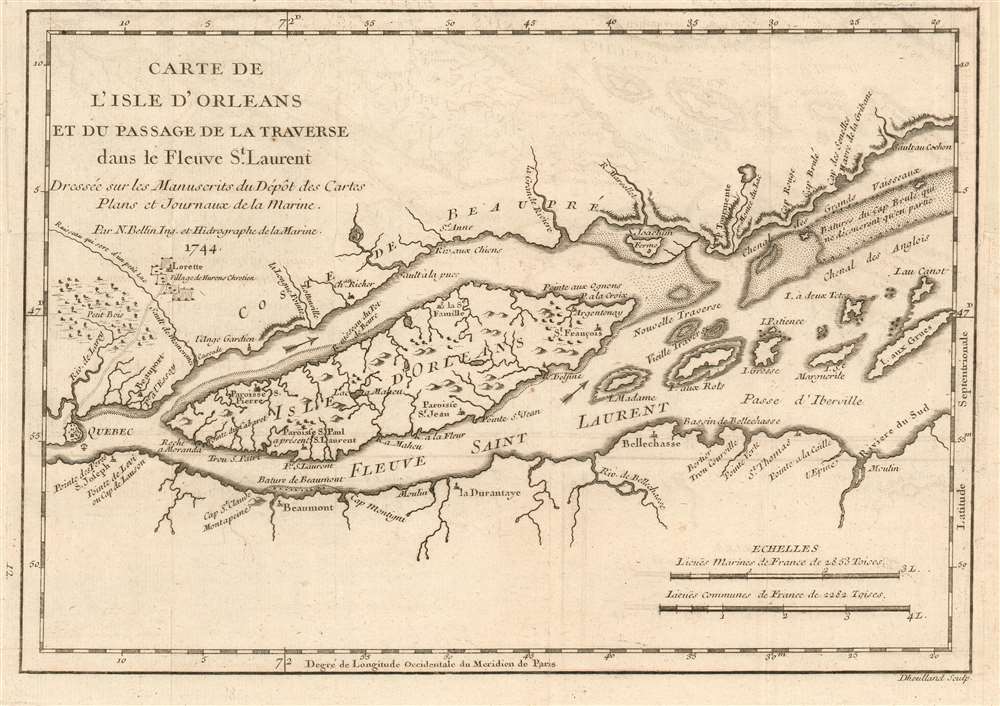
Carte de l'Isle d'Orleans et du Passage de la Traverse ans le Fleuve St.Laurent.
1744 (dated) 7.5 x 11 in (19.05 x 27.94 cm) 1 : 265000
1744 (dated) 7.5 x 11 in (19.05 x 27.94 cm) 1 : 265000
Description
This is a beautiful example of Bellin's scarce 1744 map of the Île d'Orléans in the Saint Lawrence River. The map covers from Quebec City downstream to the Batures de Cap Brule.
Bellin originally prepared this map to illustrate Pierre François Xavier de Charlevoix's Histoire et description generale de la Nouvelle France, one of the most comprehensive works on North America predating the French and Indian War. Charlevoix was a Jesuit missionary and traveler commissioned by the French Crown and the Duke of Orleans to explore French holdings in the Americas, particularly with a view towards finding a profitable route to the Pacific. Many hoped this in the network of rivers and lakes to the west of the Great Lakes, as suggested by earlier explorers and mapmakers such as Lahontan and De l'Isle. It was engraved by Desbruslins Fils of Paris. Charlevoix's history thus proved exceptionally influential as one of the most comprehensive works on North America predating the French and Indian War.
Bellin originally prepared this map to illustrate Pierre François Xavier de Charlevoix's Histoire et description generale de la Nouvelle France, one of the most comprehensive works on North America predating the French and Indian War. Charlevoix was a Jesuit missionary and traveler commissioned by the French Crown and the Duke of Orleans to explore French holdings in the Americas, particularly with a view towards finding a profitable route to the Pacific. Many hoped this in the network of rivers and lakes to the west of the Great Lakes, as suggested by earlier explorers and mapmakers such as Lahontan and De l'Isle. It was engraved by Desbruslins Fils of Paris. Charlevoix's history thus proved exceptionally influential as one of the most comprehensive works on North America predating the French and Indian War.
An Influential Work
Copies of the Histoire et Description Generale were to be found in the libraries of many 18th century luminaries, including Voltaire, Franklin, and Jefferson. Jefferson in particular admired Charlevoix's work, calling it 'a particularly useful species of reading.'Publication History and Census
The Charlevoix' Histoire et Description Generale is well represented in institutional collections. OCLC lists perhaps seventeen copies of this separate map.CartographerS
Jacques-Nicolas Bellin (1703 - March 21, 1772) was one of the most important cartographers of the 18th century. With a career spanning some 50 years, Bellin is best understood as geographe de cabinet and transitional mapmaker spanning the gap between 18th and early-19th century cartographic styles. His long career as Hydrographer and Ingénieur Hydrographe at the French Dépôt des cartes et plans de la Marine resulted in hundreds of high quality nautical charts of practically everywhere in the world. A true child of the Enlightenment Era, Bellin's work focuses on function and accuracy tending in the process to be less decorative than the earlier 17th and 18th century cartographic work. Unlike many of his contemporaries, Bellin was always careful to cite his references and his scholarly corpus consists of over 1400 articles on geography prepared for Diderot's Encyclopedie. Bellin, despite his extraordinary success, may not have enjoyed his work, which is described as "long, unpleasant, and hard." In addition to numerous maps and charts published during his lifetime, many of Bellin's maps were updated (or not) and published posthumously. He was succeeded as Ingénieur Hydrographe by his student, also a prolific and influential cartographer, Rigobert Bonne. More by this mapmaker...
Pierre François Xavier de Charlevoix, S.J. (October 24 or 29, 1682 – February 1, 1761) was a French Jesuit priest, traveller, and historian, often considered the first historian of New France. He is best known for his Histoire et description generale de la Nouvelle France, in spite of the work being primarily based upon the manuscripts compiled by Gaspard-Joseph Chaussegros de Lery, a French Canadian military engineer active throughout the Great Lakes region in the early 18th century. Charlevoix had been commissioned by the French Crown and the Duke of Orleans to explore French holdings in the Americas, primarily in order to find a profitable route to the Pacific - perhaps via the rivers and lakes west of the Great Lakes suggested by De l'Isle and Lahontan. Charlevoix was not above inventing discoveries: the imaginary islands in Lake Superior that appear frequently in 18th century maps can be laid at Charlevoix's feet, the results of his efforts to flatter his patrons (and patron saints.) Learn More...
Source
Charlevoix, Pierre François Xavier de, Histoire et description generale de la Nouvelle France, avec le journal historique d'un voyage fait par ordre du roi dans l'Amérique septentrionnale, (Paris: Chez Rollin) 1744.
Condition
Very good. Margin reinstated at insertion point. Some offsetting.
References
OCLC 495035428.