This item has been sold, but you can get on the Waitlist to be notified if another example becomes available, or purchase a digital scan.
1749 Vaugondy Map of the Cape Verde Islands
IslesCapVerd-vaugondy-1749$90.00

Title
Les Isles du Cap-Verd. Par le Sr. Robert de Vaugondy Fils de Mr. Robert Géog. ord. du Roi.
1749 (dated) 6.5 x 7.5 in (16.51 x 19.05 cm) 1 : 2000000
1749 (dated) 6.5 x 7.5 in (16.51 x 19.05 cm) 1 : 2000000
Description
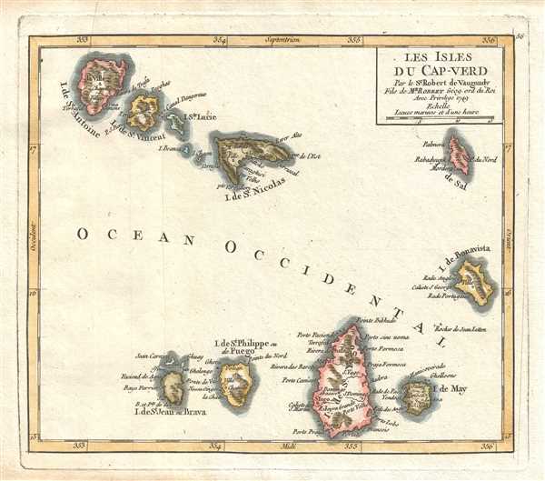
This is a hand colored 1749 Didier Robert de Vaugondy map of the Cape Verde Islands, now known as Cabo Verde. The map depicts all 10 islands in the Cape Verde archipelago, which is located 350 miles off the coast of West Africa. Each of the islands is labeled, and several locations on each of the islands are identified.
The Cape Verde Islands were uninhabited until the Portuguese discovered the islands around 1456. Portuguese settlers began arriving in 1462 and founded the first permanent European settlement in the tropics. The archipelago prospered at the height of the slave trade, and thus became a frequent target for pirates and privateers. Following the decline of the slave trade, the economy fell into a crisis. But, thanks to their position along the mid-Atlantic trade routes, the Cape Verde Islands quickly became an idea location for re-supplying ships. In 1951, Portugal changed the status of the Cape Verde Islands from a colony to an overseas province, in an effort to snuff out a growing nationalist movement. In the end, however, the Cape Verde Islands gained independence from Portugal in 1975.
Since independence, the country has developed a thriving economy. Their economy is largely service based and tourism and remittances from expatriates also play a key role. The Cape Verde Islands also strongly encourage foreign investment.
This map was published by Gilles Robert de Vaugondy in his Atlas Universel, Portatif et Militaire in the 1749 edition.
Cartographer
Robert de Vaugondy (fl. c. 1716 - 1786) was French may publishing from run by brothers Gilles (1688 - 1766) and Didier (c. 1723 - 1786) Robert de Vaugondy. They were map publishers, engravers, and cartographers active in Paris during the mid-18th century. The father and son team were the inheritors to the important Nicolas Sanson (1600 - 1667) cartographic firm whose stock supplied much of their initial material. Graduating from Sanson's maps, Gilles, and more particularly Didier, began to produce their own substantial corpus. The Vaugondys were well-respected for the detail and accuracy of their maps, for which they capitalized on the resources of 18th-century Paris to compile the most accurate and fantasy-free maps possible. The Vaugondys compiled each map based on their own geographic knowledge, scholarly research, journals of contemporary explorers and missionaries, and direct astronomical observation. Moreover, unlike many cartographers of this period, they took pains to reference their sources. Nevertheless, even in 18th-century Paris, geographical knowledge was limited - especially regarding those unexplored portions of the world, including the poles, the Pacific Northwest of America, and the interiors of Africa, Australia, and South America. In these areas, the Vaugondys, like their rivals De L'Isle and Buache, must be considered speculative or positivist geographers. Speculative geography was a genre of mapmaking that evolved in Europe, particularly Paris, in the middle to late 18th century. Cartographers in this genre would fill in unknown lands with theories based on their knowledge of cartography, personal geographical theories, and often dubious primary source material gathered by explorers. This approach, which attempted to use the known to validate the unknown, naturally engendered rivalries. Vaugondy's feuds with other cartographers, most specifically Phillipe Buache, resulted in numerous conflicting papers presented before the Academie des Sciences, of which both were members. The era of speculative cartography effectively ended with the late 18th-century explorations of Captain Cook, Jean Francois de Galaup de La Perouse, and George Vancouver. After Didier died, his maps were acquired by Jean-Baptiste Fortin, who in 1787 sold them to Charles-François Delamarche (1740 - 1817). While Delamarche prospered from the Vaugondy maps, he defrauded Vaugondy's window Marie Louise Rosalie Dangy of her rightful inheritance and may even have killed her. More by this mapmaker...
Source
Robert de Vaugondy, G., Atlas Portatif, Universel, et Militaire, (Paris: Vaugondy, Durand, Pissot) 1749.
Condition
Very good. Blank on verso. Original press mark visible.
References
Pedley, M. S., Bel et Utile, p. 207, 445. OCLC 11454595.