This item has been sold, but you can get on the Waitlist to be notified if another example becomes available, or purchase a digital scan.
1750 Bellin Map of the Maldives
IslesMaldives-bellin-1750$87.50

Title
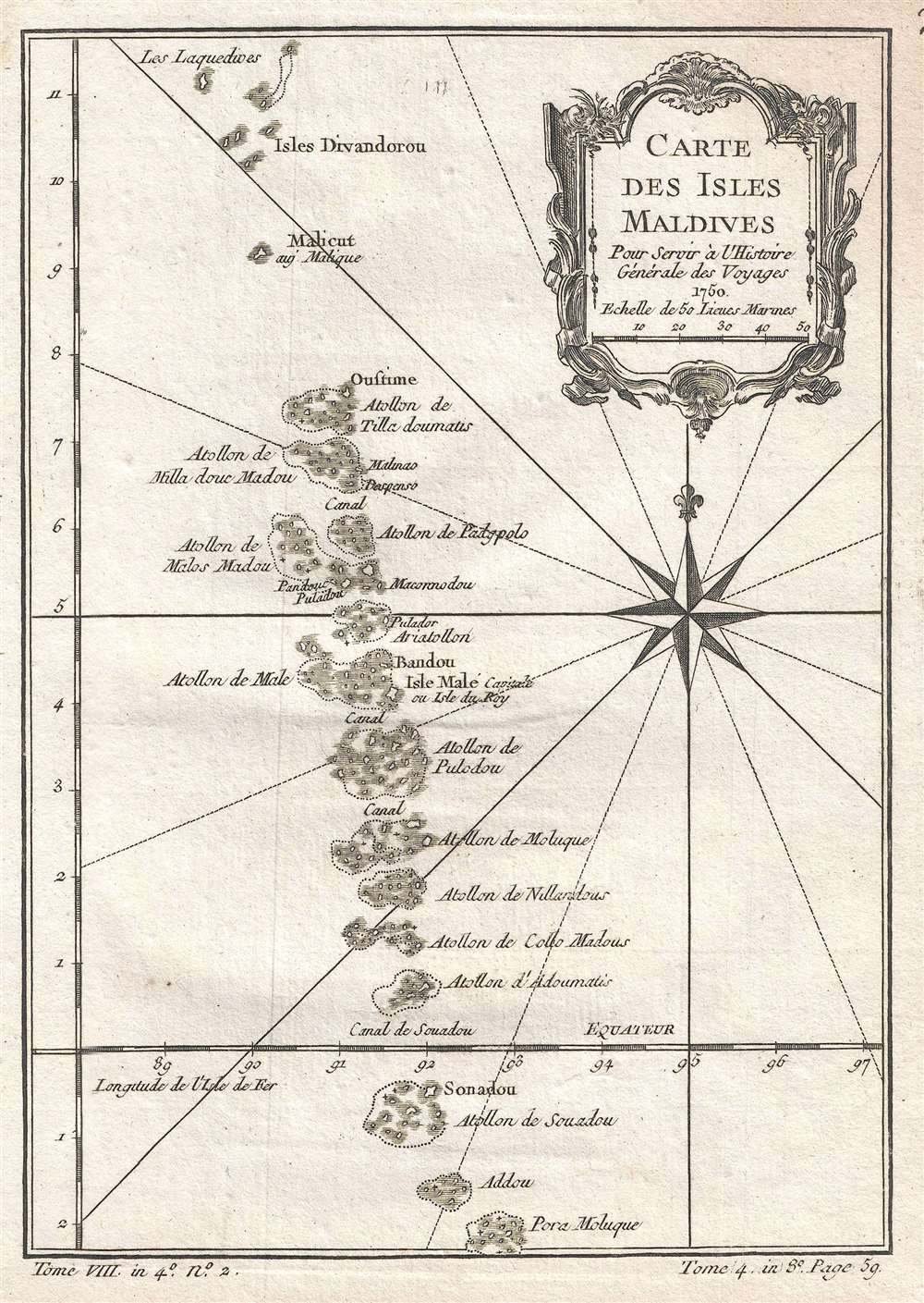
Carte des Isles Maldives. Pour Servir à l'Histoire Générale de Voyages.
1750 (dated) 9 x 6.5 in (22.86 x 16.51 cm) 1 : 730000
1750 (dated) 9 x 6.5 in (22.86 x 16.51 cm) 1 : 730000
Description
This is a 1750 Jacques-Nicolas Bellin map of the Maldives, an nation situated in the Indian Ocean about six hundred miles southwest of the Asian continent. The map depicts the archipelago from Les Laquedives to Pora Moluque. Each atoll is illustrated and labeled, as are a few of the canals between the atolls. Malé Island is situated near the center and is labeled as Isle Malé, capitale ou Isle du Roy. Malé is the modern capital of the Maldives and is on Hulhulé Island. A beautiful compass rose is situated along the right border just below the title cartouche. Today, the Maldives are a relatively major international tourist destination and the tourism industry is the single largest contributor to the country's GDP.
This map was created by Jacques-Nicolas Bellin for inclusion in Abbé Prévost's Histoire Générale des Voyages
This map was created by Jacques-Nicolas Bellin for inclusion in Abbé Prévost's Histoire Générale des Voyages
Cartographer
Jacques-Nicolas Bellin (1703 - March 21, 1772) was one of the most important cartographers of the 18th century. With a career spanning some 50 years, Bellin is best understood as geographe de cabinet and transitional mapmaker spanning the gap between 18th and early-19th century cartographic styles. His long career as Hydrographer and Ingénieur Hydrographe at the French Dépôt des cartes et plans de la Marine resulted in hundreds of high quality nautical charts of practically everywhere in the world. A true child of the Enlightenment Era, Bellin's work focuses on function and accuracy tending in the process to be less decorative than the earlier 17th and 18th century cartographic work. Unlike many of his contemporaries, Bellin was always careful to cite his references and his scholarly corpus consists of over 1400 articles on geography prepared for Diderot's Encyclopedie. Bellin, despite his extraordinary success, may not have enjoyed his work, which is described as "long, unpleasant, and hard." In addition to numerous maps and charts published during his lifetime, many of Bellin's maps were updated (or not) and published posthumously. He was succeeded as Ingénieur Hydrographe by his student, also a prolific and influential cartographer, Rigobert Bonne. More by this mapmaker...
Condition
Very good. Even overall toning. Blank on verso.
References
OCLC 956308758.