1704 Gerard Valk Map of Southern Italy (Kingdom of Naples)
ItaliaMeridionalis-valk-1704$1,200.00

Title
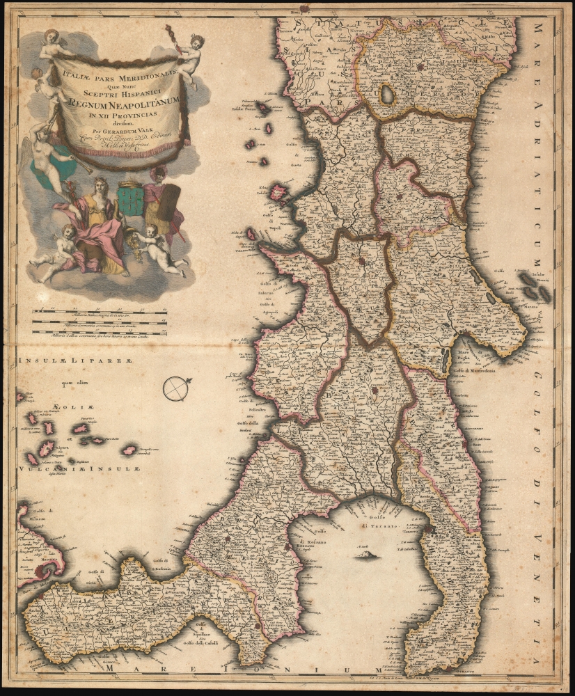
Italiae Pars Meridionalis; Quae Nunc Sceptri Hispanici Regnum Neapolitanum: in XII Provincias divisum.
1704 (undated) 24.25 x 19.75 in (61.595 x 50.165 cm) 1 : 1100000
1704 (undated) 24.25 x 19.75 in (61.595 x 50.165 cm) 1 : 1100000
Description
A rare c. 1704 Gerard Valk (Valck) map of southern Italy.
A Closer Look
Strictly oriented to the northwest, the map covers peninsular Italy from roughly Rome to the southernmost extremes of Calabria and Puglia. In the upper left is an elaborate title cartouche bearing the arms of the Kingdom of Naples, putti, and other allegorical content.Historical Context
In 1703-1704, Southern Italy was under the rule of the Spanish Habsburgs, forming part of the larger Spanish Empire. This period was marked by political and social stability, albeit under a centralized and sometimes oppressive regime. The economy was primarily agrarian, with a focus on olive oil, wine, and citrus fruits. However, the region was not immune to the troubles of Europe, as it was drawn into the wider conflicts of the Spanish Succession War (1701 - 1714). Southern Italy's strategic location made it a point of interest for major European powers, leading to occasional military skirmishes and political maneuvering. Culturally, the Baroque movement was flourishing, influencing architecture, art, and music. Despite the external influences and conflicts, local traditions and the Italian language continued to develop, laying the groundwork for a distinct Southern Italian identity.Publication History and Census
This map was first published in Amsterdam by Gerard Valk around 1700, with most authorities suggesting 1704. It was included in Valk's atlas Nova Totius Geographica Telluris Proiectio, of which only two known examples survive. Separate issue examples of the map occasionally appear in composite atlases as late as 1730. This map is rare, with no market history and examples known only in 2 institutions: the Universitäts- und Landesbibliothek Darmstadt and the Bayerische Staatsbibliothek.Cartographer
Gerard Valk (September 30, 1652 - October 21, 1726) (aka. Valck, Walck, Valcke), was a Dutch engraver, globe maker, and map publisher active in Amsterdam in the latter half of the 17th century and early 18th century. Valk was born in Amsterdam where his father, Leendert Gerritsz, was a silversmith. He studied mathematics, navigation, and cartography under Pieter Maasz Smit. Valk and moved to London in 1673, where he studied engraving under Abraham Blooteling (or Bloteling) (1634 - 1690), whose sister he married, and later worked for the map sellers Christopher Browne and David Loggan. Valke and Blooteling returned to Amsterdam in 1680 and applied for a 15-year privilege, a kind of early copyright, from the States General, which was granted in 1684. In 1687, he established his own firm in Amsterdam in partnership with Petrus (Pieter) Schenk, who had just married his sister, Agata. They published under the imprint of Valk and Schenk. Also, curiously in the same year Valk acquired the home of Jochem Bormeester, also engraver and son-in-law of art dealer Clement De Jonghe. Initially Valk and Schenk focused on maps and atlases, acquiring the map plates of Jodocus Hondius and Jan Jansson in 1694. Later, in 1701 they moved into the former Hendrick Hondius (the younger) offices where they began producing globes. Valk and Schenk soon acquired the reputation of producing the finest globes in the Netherlands, a business on which they held a near monopoly for nearly 50 years. In 1702, Valk joined the Bookseller's Guild of which he was promptly elected head. Around the same time, Gerard introduced his son, Leonard, who was married to Maria Schenk, to the business. Leonard spearheaded the acquisition of the map plates of Frederick de Wit in 1709. Nonetheless, Leonard was nowhere near as sophisticated a cartographer or businessman as his father and ultimately, through neglect, lost much the firm's prestige. After his death, the firm was taken over by his widow Maria. More by this mapmaker...
Condition
Good. Some foxing and overall toning. Some colors oxidized causing brittleness to paper. Backed on archival tissue. Minor reinforcements.
References
OCLC 159800435. Gunther, R. T., A Bibliography of Topographical and Geological Works on the Phlegraean Fields, p 34.