1729 Clüver Map of Southern Italy in Antiquity
Italy-cluver-1729$275.00

Title
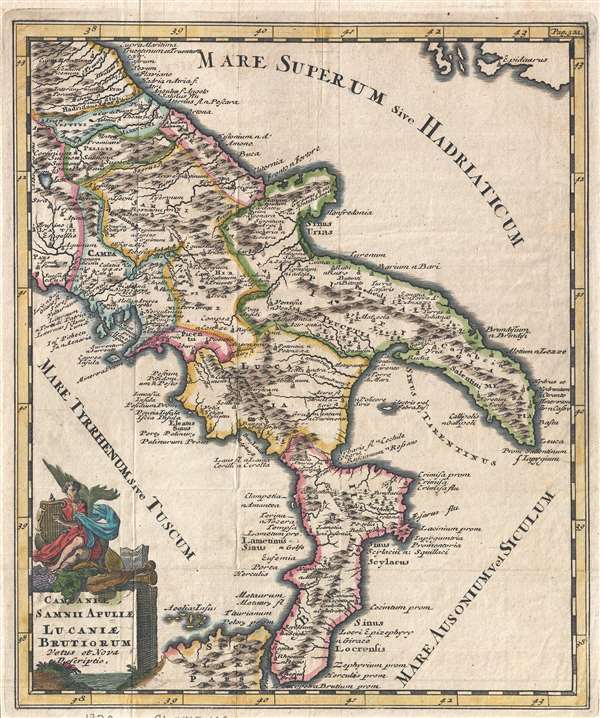
Campaniae, Samnii Apuliae Lucaniae Brutiorum Vetus et Nova Descriptio.
1729 (undated) 10.5 x 8 in (26.67 x 20.32 cm) 1 : 2600000
1729 (undated) 10.5 x 8 in (26.67 x 20.32 cm) 1 : 2600000
Description
An uncommon 1729 Philipp Clüver map of southern Italy in antiquity. The map covers from the Lago di Bolsena to the southernmost boot of Italy, including parts of northern Sicily and from the Tyrrhenian Sea to the Adriatic. Place names, as they were known in antiquity are noted throughout. An attractive decorative title cartouche appears in the lower left quadrant.
The Crypto-Island of 'M. Sardo'
In applying ancient names to modern topography, the Clüver utilized modern errors as well. As authoritative as Magini's 1608 wall map Italia Nuova was, one of its hallmarks - and those maps based on it - was the placement of a mysterious mountainous island 'M. Sardo' in the Gulf of Taranto. Despite being reproduced faithfully on near every 17th century map of the peninsula, the origins of this imaginary island have long been obscure. More recently, the scholar/collector Vladimirio Valerio discovered a interesting notation on the Otranto map in the 1595 Stigliola manuscript Atlas of the Kingdom of Naples (added to his collection in 1975). On that manuscript, a crude mountain-hump is mapped in the Gulf of Taranto - the first known instance in print or otherwise of any such 'M. Sardo' in those waters. While no such island or mountain actually exists, there is, near the tip of Otranto, a mountaintop village - Monte Sardo - notable for its visibility both from the Gulf of Otranto and the Gulf of Venice. Thus the manuscript 'M. Sardo' is a crude coastal profile highlighting a observable coastal navigational feature. Valerio's theorizes that, in compiling his masterpiece map of Italy, Magini consulted the Stigliola as the best and most detailed map of southern Italy. In doing so, he misinterpreted the navigational notation, preserving it as a literal mountain in the middle of the Gulf, and retaining the name M. Sardo. Magini's work was so authoritative that Blaeu copied the map, errors and all; and in turn, with few exceptions, the rest of the European mapmaking community followed. Clüver's 'Electra vel Febra. Ins.' mark an imaginary archipelago corresponding with the imaginary M. Sardo.
Cartographer
Philipp Clüver (also Klüwer, Cluwer, or Cluvier, Latinized as Philippus Cluverius and Philippi Cluverii) (1580 - December 31, 1622) was a German geographer and historian active in Leiden in the late 16th and early 17th centuries. Clüver was born in the Royal Prussian city of Danzig (Gdansk), then a province of the Kingdom of Poland. He study of law at the University of Leiden before turning his attention to history and geography. Cluver traveled, mostly by foot, extensively throughout Europe, spending time in Germany, England, Scotland, Holland and Italy. On returning to Leiden he was given a special appointment as geographer and put in charge of the university's library. Cluver is best known for his general study of the geography of antiquity. A popular Enlightenment era field of study, antiquarian geography attempted to resolve place names known from classical literature but, by the time of the Renaissance, geographically confused. Cluver based his research not only on classical literary sources, but — and this was his primary contribution to the genre — also his extensive and local inspections of sites. Today he is considered one of the founding fathers of historical geography. Cartographically Cluver's most prominent works include his edition of Ptolemy's Geographia (based on Mercator's edition of 1578) and for miniature atlases that were reprinted for most of the 17thand 18th centuries. Cluver was also known as Klüwer, Cluwer, or Cluvier, Latinized as Philippus Cluverius and Philippi Cluverii. He died in Leiden in 1622. More by this mapmaker...
Condition
Very good. Some wear on original fold lines. Blank on verso.
References
OCLC 633162440.