1677 De Wit Map of Italy
Italy-dewit-1677$1,250.00
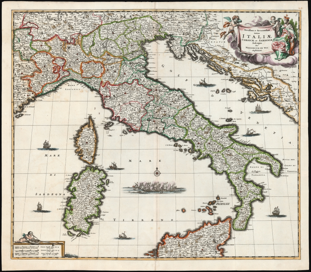

Title
Novissima et Accuratissima totius Italiae, Corsicae et Sardiniae Descriptio Per Fredericum De Wit Amstelodami.
1677 (undated) 19.25 x 22.25 in (48.895 x 56.515 cm) 1 : 2400000
1677 (undated) 19.25 x 22.25 in (48.895 x 56.515 cm) 1 : 2400000
Description
This is a first-state example of Frederik de Wit's map of Italy, engraved as early as 1671.
The map is richly decorative, with a beautiful allegorical cartouche in the upper right featuring two putti on the wing and a seated, imperious woman wearing a castle-crown surmounted with a star: Italia Turrita e Stellata, 'turreted and stellate Italy,' the allegorical personification of Italy. Seated with a cornucopia at her side, the Italia Turrita is an icon of Italian civic heraldry. Her walled crown appears in the iconography of many Italian cities, symbolically conveying the royalty and nobility of Italy, while the cornucopia alludes to its agricultural abundance. The star represents Italy's 'stellar' destiny.
In the lower left, the scales of the map are given in French, Italian, and German miles. These are displayed on a plinth, upon which a third putto plays with navigational instruments. De Wit's seas are plied by seven superbly engraved ships, and a fierce naval battle is occurring in the Tyrrhenian Sea.
A Closer Look
The map covers the Italian Peninsula in its entirety and includes the Dalmatian Coast (at the time controlled by the Republic of Venice) as well as the islands of Corsica, Sardinia, and parts of Sicily. As with virtually every map of Italy produced in the 17th century, De Wit follows the model established by Magini's monumental 1608 Italia Nuova. Magini's map was justifiably influential, rendering the whole of Italy and its islands in detail, with the river systems clearly presented and mountains shown pictorially.The map is richly decorative, with a beautiful allegorical cartouche in the upper right featuring two putti on the wing and a seated, imperious woman wearing a castle-crown surmounted with a star: Italia Turrita e Stellata, 'turreted and stellate Italy,' the allegorical personification of Italy. Seated with a cornucopia at her side, the Italia Turrita is an icon of Italian civic heraldry. Her walled crown appears in the iconography of many Italian cities, symbolically conveying the royalty and nobility of Italy, while the cornucopia alludes to its agricultural abundance. The star represents Italy's 'stellar' destiny.
In the lower left, the scales of the map are given in French, Italian, and German miles. These are displayed on a plinth, upon which a third putto plays with navigational instruments. De Wit's seas are plied by seven superbly engraved ships, and a fierce naval battle is occurring in the Tyrrhenian Sea.
The Crypto-Island of 'M. Sardo'
As authoritative as Magini's 1608 wall map Italia Nuova was, one of its hallmarks was the placement of a mysterious, mountainous island, 'M. Sardo', in the Gulf of Taranto. Despite being reproduced faithfully on nearly every 17th-century map of the peninsula, the origins of this imaginary island have long been obscure. More recently, the scholar-collector Vladimirio Valerio discovered a notation on the Otranto map in the 1595 Stigliola manuscript Atlas of the Kingdom of Naples (added to his collection in 1975). On that manuscript, a crude mountain-hump is mapped in the Gulf of Taranto - the first known instance in print or otherwise of any such 'M. Sardo' in those waters. While no such island exists, there is, near the tip of Otranto, a mountaintop village - Monte Sardo - notable for its visibility both from the Gulf of Otranto and the Gulf of Venice. Thus, the manuscript 'M. Sardo' is a crude coastal profile highlighting an observable coastal navigational feature. Valerio theorizes that, in compiling his masterpiece map of Italy, Magini consulted the Stigliola as the best and most detailed map of southern Italy. In doing so, he misinterpreted the navigational notation, preserving it as a literal mountain in the middle of the Gulf and retaining the name M. Sardo. Magini's work was so authoritative that Blaeu copied the map, errors and all. In turn, with few exceptions, the rest of the European mapmaking community followed.Publication History and Census
De Wit's original engraving was executed between 1671 and 1676 as a separate issue or for inclusion in composite atlases such as Visscher's Atlas Contractus. (We see an example of this particular state of the map in a 1677 Visscher atlas, for example.) A second state of the map, with more place names marked around Corsica and more sea notations, would appear in De Wit's own atlas in the following decade. At least one further state, bearing De Wit's privilege, was printed around 1690. After his death, the plate was sold to Peter Mortier and reissued with additions by his successors Covens and Mortier. The map, with a variety of dates, appears to be well-represented in institutional collections.CartographerS
Frederik de Wit (1629 - 1706) was a Dutch Golden Age cartographer active in the second half of the 17th and the early 18th centuries. De Wit was born of middle class Protestant stock in the western Netherlandish town of Gouda. He relocated to Amsterdam sometime before 1648, where he worked under Willem Blaeu. His first attributed engraved map, a plan of Haarlem for Antonius Sanderus' Flandria Illustrata, was issued around this time. He struck out on his own in 1654. The first chart that De Wit personally both drew and engraved was most likely his 1659 map of Denmark, REGNI DANIÆ Accuratissima delineatio Perfeckte Kaerte van ‘t CONJNCKRYCK DENEMARCKEN. His great wall map of the world and most famous work, Nova Totius Terrarum Orbis Tabula appeared one year later. Following the publication of his wall map De Wit quickly rose in prominence as a both cartographer and engraver. He married Maria van der Way in 1661 and through her became a citizen of Amsterdam in 1662. Around this time he also published his first major atlas, a composite production ranging in size from 17 to over 150 maps and charts. Other atlases and individual maps followed. In 1689 De Wit was granted a 15 year Privilege by the Dutch States General. (An early copyright that protected the recipient's rights to print and publish.) He was recognized with the honorific 'Good Citizen' in 1694. De Wit died in 1706 after which his wife Maria continued publishing his maps until about 1710. De Wit's son, Franciscus, had no interest in the map trade, instead choosing to prosper as a stockfish merchant. On her own retirement, Maria sold most De Wit maps and plates at a public auction. Most were acquired by Pieter Mortier and laid the groundwork for the 1721 rise of Covens and Mortier, the largest Dutch cartographic publishing house of the 18th century. More by this mapmaker...
Giovanni Antonio Magini (June 13, 1555 - February 11, 1617) was an Italian astronomer, astrologer, cartographer, and mathematician. Born in Padua, he completed his studies in philosophy in Bologna in 1579. In 1588 he was chosen over Galileo Galilei as the chair of mathematics at the University of Bologna after the death of Egnatio Danti. Magini was a prolific writer, putting forth theories of celestial motion (he was a supporter of a geocentric solar system), the use of quadrants in surveying and astronomy, and trigonometry. In 1608, Magini produced the first map of Italy to improve on that of Gastaldi: his meticulously researched and beautifully engraved 8-sheet Italia Nuova was hugely influential: upon its publication, Blaeu promptly copied it to produce his own wall map of Italy; the rest of the mapmaking establishment swiftly followed suit. Consequently, virtually every 17th century map of Italy can be identified as a derivative of Magini's monumental achievement. His atlas, Atlante geografico d’Italia, was published posthumously by his son in 1620. This work was intended to include maps of every Italian region with exact nomenclature and historical notes. He also served as court astrologer for the Duke of Mantua. Learn More...
Condition
Very good. Mend to bottom centerfold just entering image. Else excellent with beautiful original color.
References
Rumsey 12220.030 (dated conjecturally to 1682) OCLC 1118597443.