
This item below is out of stock, but another example (left) is available. To view the available item, click "Details."
Details
1747 Bowen Map of Northern Italy with a Nautical Chart of Livorno
1747 (undated) $250.00
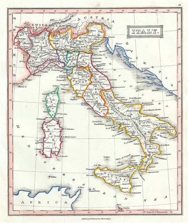
1845 Ewing Map of Italy
Italy-ewing-1845$50.00

Title
Italy.
1845 (undated) 9.5 x 8 in (24.13 x 20.32 cm) 1 : 6250000
1845 (undated) 9.5 x 8 in (24.13 x 20.32 cm) 1 : 6250000
Description
This is an attractive 1845 map of Italy by Thomas Ewing. It covers the pre-Garibaldi Italy split into numerous small duchies and states from Venetian Lombardy south to Sicily and Malta. Also includes the islands of Sardinia and Corsica. The map is color coded according to duchies, with relief shown by hachures. Cities, towns, rivers, mountains and other topographical features are noted.
At this time in history, the peninsula was undergoing Risorgimento, Italy's march toward national solidarity. Revolutionary sentiments favoring the unification of Italy were gaining popularity under Giuseppe Garibaldi, paving the way to Italian solidarity. This period thus witnessed the birth of the 'La Giovine Italia' Italian solidarity movement. In 1830, a series of insurrections throughout Italy lead to the adoption of the Tricolore and nearly established a united Italian state. Unfortunately, in 1831, Pope Gregory XVI invited the Austrian army to help crush the insurrections, postponing the push for Italian solidarity until the Revolutions of 1848.
This map was published in 1845 by Oliver and Boyd as part of Ewing's New General Atlas.
Source
Oliver and Boyd, Ewing's New General Atlas: containing Distinct Maps of all the Principal States and Kingdoms throughout the World, (Edinburgh) 1845.
Condition
Very good. Minor foxing at places. Blank on verso.