1803 / 1820 Johann Walch Map of Italy: Separately Issued
Italy-walch-1803$500.00

Title
Carta D'Italia secondo la presento Costituzione/ Charte von Italien nach der dermaligen Verfassung : auch mit dessen alten und neuen Grenzen : nach den bewährtesten Hülfsmitteln neu entworfen und gezeichnet.
1803 (dated) 20.5 x 23.75 in (52.07 x 60.325 cm) 1 : 2400000
1803 (dated) 20.5 x 23.75 in (52.07 x 60.325 cm) 1 : 2400000
Description
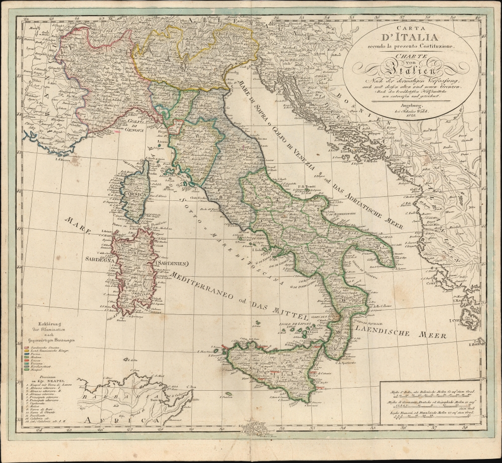
This is an 1820 Johann Walch map of Italy, issued during the Napoleonic Wars (1803-1815). Although initially issued in 1803, the map underwent regular updates due to the tumultuous political changes over the subsequent decades. This 1820 example is the last edition, published by Johann Sebastian, Walch's heir, likely as a separate issue.
The entities highlighted in the current 1820 map are very different. France and Austria are off the list, and the Kingdom of Lombardy-Venetia is named as a crown land of the Austrian Empire. The largest change is in the delineation of the Kingdom of Naples, which has borders consistent with the 1816 unification of Naples and Sicily.
A Closer Look
Embracing Italy and environs, the map reaches as far north as Lake Geneva in Switzerland, thus revealing part of France and the southern extents of Germany. The Dalmatian coast and Albania are included as far south as the islands of Cefalonia and Zante. Corsica, Sardinia, and Sicily are included in full. Part of the Tunisian coast appears in the extreme south, and the island of Malta intrudes on the bottom border. Scales of miles appear in the lower right, with an elegant oval cartouche containing titles in Italian and German. In the lower left are two legends: one uses a color key to identify political regions, and the other a numerical key to identify the provinces of the Kingdom of Naples.Tracking Big Changes
The title ('Map of Italy, according to the Present Constitution') refers to the constitution of the 1802-1805 Italian Republic, successor to the Napoleonic Cisalpine Republic. The 1803 map possessed a key in the lower left marking territories controlled by France, Austria, the Italian Republic, the Ligurian Republic, the Republic of Lucca, the Kingdom of Etruria, the Papal States, and the Kingdom of Naples. The borders thus delineated reflect a very brief period. (Etruria would not last beyond 1807, for example.)The entities highlighted in the current 1820 map are very different. France and Austria are off the list, and the Kingdom of Lombardy-Venetia is named as a crown land of the Austrian Empire. The largest change is in the delineation of the Kingdom of Naples, which has borders consistent with the 1816 unification of Naples and Sicily.
Publication History and Census
This map was first published by Johann Walch in Augsburg in 1803 for inclusion in his Allgemeiner Atlas. We are aware of editions dated 1806, 1811, 1818, and 1820. Most of these separate maps are cataloged in a few examples. This 1820 state is listed in only four institutional collections.Cartographer
Johannes Walch (November 25, 1757 - March 23, 1815) was a German painter, draftsman, engraver, cartographer and publisher. He was the son of abusinessman, amateur painter and engraver Sebastian Walch; he received training as a miniature painter in Augsburg, Geneva and the Vienna Art Academy. After a two-year trip to Italy, he settled in Augsburg, where he married the eldest daughter of the Augsburg-based engraver and publisher Johann Martin Will, and worked in his father-in-law's publishing house. His contributions led the publisher to focus more heavily on As a result, the publisher increasingly turned to map production, heavily supported by the acquisition of material from Lotter and Seutter. After Will's death in 1806, Walch inherited the firm and continued to increase its importance as a map publisher. His son Johann Sebastian Walch (1787–1840) would inherit the publishing house. More by this mapmaker...
Condition
Very good. Backed with thick paper by a 19th century binder; Wear at juncture of folds with very slight loss. Original outline color.
References
OCLC 806980754.