1783 Rizzi-Zannoni Map of Italy (2 parts)
Italy-zannoni-1783$550.00
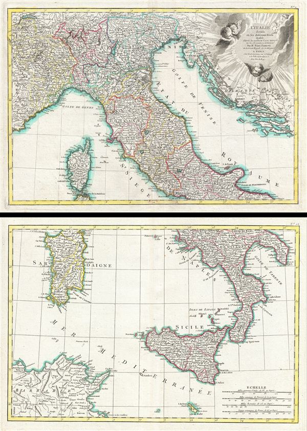

Title
L'Italie divisee en ses differens Etats dress d'apres les meilleurs Cartes appuyee sur les Observations Astromom'.
1783 (undated) 26 x 18 in (66.04 x 45.72 cm) 1 : 2050000
1783 (undated) 26 x 18 in (66.04 x 45.72 cm) 1 : 2050000
Description
A beautiful example of Rizzi-Zannoni's 1783 two sheet decorative map of Italy. The upper sheet covers from Lake Geneva and the Venetian States south to include Rome, Corsica, and Capitana. It also includes the Gulf of Venice and the states of Dalmatia, Herzegovina and Murlaka. A large decorative cartouche featuring solar rays and numerous putti (little cherubs) appears in the upper right quadrant. The lower sheet covers from Naples south to include Sicily, Malta, Sardinia and parts of Tunisia and Algeria in North Africa.
This map shows the Italian peninsula prior to its struggle for national solidarity which would emerge as a movement about 50 years later in the early 19th century. The peninsula is divided into numerous independent states, duchies, republics, kingdoms and, of course, the Papal States (States of the Church).
A fine map of the region. Drawn by Rizzi-Zannoni in 1783 for issue as plate nos. 11-12 in Jean Lattre's 1783 issue of the Atlas Moderne.
CartographerS
Giovanni Antonio Bartolomeo Rizzi Zannoni (September 2, 1736 - May 20, 1814) was an 18th century Italian cartographer active in Venice and Naples. Zannoni was born in Padua, Italy on September 2, 1736. Between 1749 and 1751 Zannoni studied Astronomy at the University of Padua under John Polen, a prominent astronomer of the period. After leaving the University, Zannoni was commissioned by the King of Poland, Augustus III, to map that country. Zannoni's subsequent survey is considered the first accurate triangulation of Poland. Afterwards Zannoni's services were in high demand and he traveled around much of Europe, working on various surveys in Denmark, Germany, Prussia, and Sweden. Around 1757 Zannoni was caught up in the hostilities surrounding the Seven Year War and, after one battle, was taken to Paris as a prisoner of war. Paris must have suited Zannoni for he remained for nearly 20 years, even taking service with the Paris Engineer's Office. It was also here in Paris the Zannoni developed the cartographic contacts that would lead to his most prolific cartographic publications, including the Atlas Moderne in conjunction with Lattre. In 1781, Zannoni was called to Naples by the Bourbon monarchy to help in the revision of the Charter of 1769. Afterwards he stayed on and produced a numerous important maps of the Kingdom of Naples. Zannoni is considered a careful and precise cartographer and his work, particularly the maps he made in Naples, have been praised by R.V. Tooley as 'remarkable for a marvelously minute attention to detail, and amply deserves the commendation passed upon it by Sir George Fordham' (Tooley, Maps and Mapmakers, 21). Zannoni would spend the remainder of his days in Naples and passed away on May 20, 1814. More by this mapmaker...
Jean Lattré (170x - 178x) was a Paris based bookseller, engraver, globe maker, calligrapher, and map publisher active in the mid to late 18th century. Lattré published a large corpus of maps, globes, and atlases in conjunction with a number of other important French cartographic figures, including Janvier, Zannoni, Bonne and Delamarche. He is also known to have worked with other European cartographers such as William Faden of London and the Italian cartographer Santini. Map piracy and copyright violations were common in 18th century France. Paris court records indicate that Lattré brought charges against several other period map publishers, including fellow Frenchman Desnos and the Italian map engraver Zannoni, both of whom he accused of copying his work. Lattré likes trained his wife Madame Lattré (né Vérard), as an engraver, as a late 18th century trade card promotes the world of 'Lattré et son Epouse.' Lattré's offices and bookshop were located at 20 rue St. Jaques, Paris, France. Later in life he relocated to Bordeaux. Learn More...
Source
Lattre, Jean, Atlas Moderne ou Collection de Cartes sur Toutes les Parties du Globe Terrestre, c. 1783.
Condition
Very good condition. Two sheets. Original centerfolds exhibit minor toning. Blank on verso.
References
Rumsey 2612.028, 2612.029, 2612.030. Phillips (Atlases) 664. National Maritime Museum, 215.