This item has been sold, but you can get on the Waitlist to be notified if another example becomes available, or purchase a digital scan.
1822 Franz Pluth Map of Jamaica (West Indies)
Jamaica-pluth-1822$75.00

Title
Charte von Jamaica.
1822 (dated) 6.75 x 11.5 in (17.145 x 29.21 cm) 1 : 922000
1822 (dated) 6.75 x 11.5 in (17.145 x 29.21 cm) 1 : 922000
Description
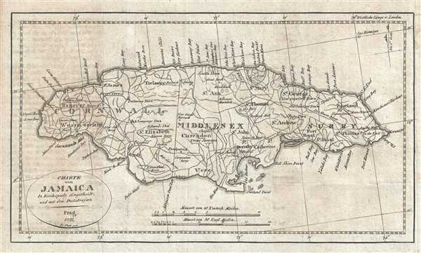
This is an 1822 Franz Pluth map of Jamaica. The map depicts the entire island in wonderful detail, labeling towns and villages, including Kingston, along with parishes and counties. Numerous roads traverse the island. Points along the coastline are also labeled.
This map was engraved by Franz Pluth and published in 1822.
This map was engraved by Franz Pluth and published in 1822.
Cartographer
Franz Pluth (1800 - 1871) was an engraver based in Prague, the capital of the Kingdom of Bohemia, then part of the Habsburg Austrian Empire. Pluth was born in Prague and most likely died in Zbraslav. He was active as a map engraver until at least 1848. His work is similar in style to that of Karl Ferdinand Weiland, a prolific German engraver, with whom he may have worked. More by this mapmaker...
Source
Linder, F. L., Neueste Länder - und Völkerkunde, ein geographisches Lesebuch für alle Stände. , (Prague) 1820.
Linder's book is typically dated 1820, but contains maps dated between 1816 and 1825.
Condition
Very good. Light wear along original fold lines. Blank on verso.