1873 Beers Map of Jamaica Village, Queens, New York City
JamaicaVillage2-beers-1873$250.00

Title
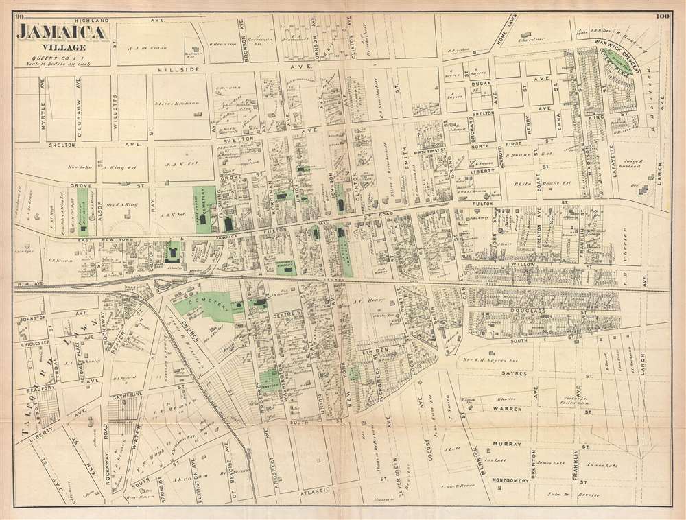
Jamaica Village, Queens Co. L.I.
1873 (undated) 17 x 22.75 in (43.18 x 57.785 cm) 1 : 1584
1873 (undated) 17 x 22.75 in (43.18 x 57.785 cm) 1 : 1584
Description
Probably the finest atlas map of the town of Jamaica to appear in the 19th century, this is an 1873 Fredrick W. Beers map of the town of Jamaica Village, Queens, New York. The map depicts the area from roughly modern-day Highland Avenue to Atlantic Avenue and from Myrtle Avenue to Franklin Avenue. Highly detailed, individual property owners throughout the village are identified, several of which own rather large amounts of property. Numerous buildings are also labeled, including the ladies' seminary, the Union Hall Academy, the public school, Presbyterian church, and town hall. Both the Long Island Railroad and the South Side Railroad are illustrated and labeled, as are nearly all the streets.
This map was prepared by Beers, Comstock & Cline out of their office at 36 Vesey Street, New York City, for inclusion in the first published atlas of Long Island, the 1873 issue of Atlas of Long Island, New York.
This map was prepared by Beers, Comstock & Cline out of their office at 36 Vesey Street, New York City, for inclusion in the first published atlas of Long Island, the 1873 issue of Atlas of Long Island, New York.
Cartographer
The Beers family (Fredrick, Silas, James and Daniel) (fl. c. 1850 - 1886), along with Charles and Augustus Warner, were prominent map publishers working from the 1850s to the late 1880s. Often publishing under the Warner & Beers designation, the combined firms produced a series of important state and county atlases and map of much of the northeastern United States. Many of their regional maps are among the most detailed and well laid out maps ever produced of their respective regions. Because Warner & Beers county maps were often detailed down to the individual homes and landowners, they have become highly sought after by general and family historians. In additional to producing maps of surpassing detail, Warner & Beers also maintained an earlier generation's attention to detail and quality while publishing in an era ever increasingly dominated by the low cost printing methods used by the publishing empires of Rand McNally and George Cram. More by this mapmaker...
Source
Atlas of Long Island, New York. From Recent Actual Surveys and Records Under the Superintendence of F. W. Beers. (1873 First Edition).
Condition
Very good. Even overall toning. Light transference. Closed minor margin tears professionally repaired on verso. Two closed one inch tears at fold intersection professionally repaired on verso. Blank on verso.
References
New York Public Library, Map Division, 1527299. OCLC 732329453.