This item has been sold, but you can get on the Waitlist to be notified if another example becomes available, or purchase a digital scan.
1787 Perouse Map of Northern Japan, Hokkaido, and the Kuril Islands
JapanHokkaidoCompagnie-perouse-1787$250.00

Title
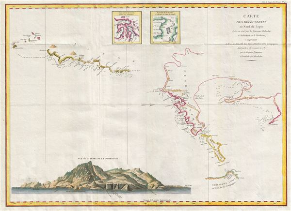
Carte des decouvertes au nord du Japon. Faites en 1643 par les Vaisseaux Hollandais le Kastrikum et le Breskens, comprenant la Terre de Jeso, l'Ile des Etats et la Terre de la Compagnie, dont partie a ete reconnue en 1787 par les Fregates Francaises la Boussole et l'Astrolabe.
1787 (dated) 20 x 27 in (50.8 x 68.58 cm) 1 : 2800000
1787 (dated) 20 x 27 in (50.8 x 68.58 cm) 1 : 2800000
Description
An important 1787 map of northern Japan, Hokkaido, and the Kuril Islands by the French navigator Jean-Francois de Galaup, Comte de Laperouse. Oriented to the west, this map covers from the small islands due south of Yokohama Bay and northwards as far as Sakhalin and east to the Kuril Island of Iturup (Compagnies Landt). A large and dramatic view of Terre da la Compagnie (Iturup) decorates the lower left quadrant. Two small inset maps at top center are drawn from the works of Scheuchzer and Kampfer's History of Japan.
The Laperouse expedition was the first significant European exploration of this region since the 17th century treasure hunting voyage of Dutchmen Maerten de Vries and Cornelis Jansz Coen. The Perouse expedition closely followes the Vries-Coen voyage, which it references in the title, skirting the same coast, sighting the same islands, and making many of the same errors. While more detailed than the earlier maps associated with the Vries-Coen voyage, it offers little new information of significance save, perhaps, a few new soundings and the fine view of Terre de la Compagnie in the lower left quadrant. Like Vries and Coen, the Laperouse expedition failed to identify Hokkaido as an island and tentatively joines it to the southern forks of Sakhalin. Also like Vries and Coen, Laperouse fails to explore Compagnie (Iturup) but follows cartography with an excessive and erroneous mapping of the island. This map was engraved by Herault and published as plate no. 47 in the 1797 French edition of the Atlas du voyage de La Perouse
The Laperouse expedition was the first significant European exploration of this region since the 17th century treasure hunting voyage of Dutchmen Maerten de Vries and Cornelis Jansz Coen. The Perouse expedition closely followes the Vries-Coen voyage, which it references in the title, skirting the same coast, sighting the same islands, and making many of the same errors. While more detailed than the earlier maps associated with the Vries-Coen voyage, it offers little new information of significance save, perhaps, a few new soundings and the fine view of Terre de la Compagnie in the lower left quadrant. Like Vries and Coen, the Laperouse expedition failed to identify Hokkaido as an island and tentatively joines it to the southern forks of Sakhalin. Also like Vries and Coen, Laperouse fails to explore Compagnie (Iturup) but follows cartography with an excessive and erroneous mapping of the island. This map was engraved by Herault and published as plate no. 47 in the 1797 French edition of the Atlas du voyage de La Perouse
Cartographer
Jean François de Galaup, Comte de La Pérouse (August 23, 1741 - 1788) was a French naval officer, navigator, and explorer active in the later part of the 18th century. Born into a noble family of Albi, France, La Perouse entered the navel college of Brest at just 15. At seventeen La Perouse made his first naval voyage, a supply expedition to the fort of Louisbourg in New France. He later participated in a number of naval battles, mostly against the English, and eventually rose to the rank of Commodore. In 1782 he captured the English forts Prince of Wales and York, making a name for himself back in France. Following the British defeat at the end of the American Revolutionary War, La Perouse was appointed by Louis XVI to lead an expedition of discovery circumnavigating the globe. The goal of the expedition was to complete and correct the maps of the Pacific drawn by Captain Cook. La Perouse's two frigates, the Astrolabe and the Boussole rounded Cape Horn and entered the Pacific in 1785. Crisscrossing the Pacific from Macau and Japan to Alaska, Vancouver, and the Hawaiian Islands Perouse made numerous discoveries and adding considerably to the cartographic corpus, particularly along the coast of British Columbia and around Japan. In Australia La Perouse sent his last letter back to France containing all of his maps and research. Tragically, on the return voyage La Perouse ran into a violent storm which left both of his frigates shipwrecked on the Polynesian island of Vanikoro, part of the Santa Cruz Group. Some of the survivors of the shipwrecks seem to have managed to live on the island for years afterwards. As late as 1790 the English Captain Edward Edwards saw smoke signals coming from Vanikoro but foolishly declined to investigate. Expeditions in 2005 and in 2008 identified the remains of both ships and retuned numerous artifacts from the ill-fated expedition to France. The importance of La Perouse's discoveries was, unfortunately, not seriously appreciated until many years later because, when the La Perouse maps were finally published in 1797, newer more accurate maps of the region were already in circulation. Nonetheless, La Perouse remains of the titans of Pacific exploration and he work paved the path forward for all future expeditions to the region. More by this mapmaker...
Source
La Perouse, Jean-Francois de Galaup, comte de, Atlas du voyage de La Perouse, (Paris) 1797.
Condition
Very good. Original fold lines exhibit minor wear.
References
Rumsey 3355.047.