This item has been sold, but you can get on the Waitlist to be notified if another example becomes available, or purchase a digital scan.
1749 Vaugondy Map of Japan and Korea (Sea of Korea)
Japon-vaugondy-1749$125.00

Title
Le Japon Par le Sr. Robert de Vaugondy Fils de Mr. Robert Geog. du Roi.
1749 (dated) 6.75 x 6.75 in (17.145 x 17.145 cm) 1 : 15800000
1749 (dated) 6.75 x 6.75 in (17.145 x 17.145 cm) 1 : 15800000
Description
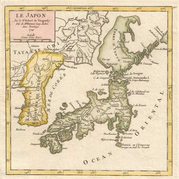
This is a hand colored 1749 Didier Robert de Vaugondy map of Japan and Korea, with Sea of Korea identified. The map centers on the home islands of Japan and depicts from Korea and China to the Pacific Ocean (Ocean Oriental). Japan itself is dotted with cities and towns, including Osaka (Osaca) and Nagasaki (Nangasaki). China is labeled as 'Chinese Tartary' and Korea is the Kingdom of Korea. The Island of Hokkaido, here identified as Terre d'Yedso, is joined with southern Sakhalin, suggesting a very primitive understanding of the region.
Just east of Hokkaido (Yedso) there is an unusual Terre de la Compagnie, reflecting preliminary sightings of the Japanese Kuril Islands in 1643 by the Dutch navigators Maerten de Vries and Cornelis Jansz Coen. Vries and Coen discovered the Kuril Islands while searching for Juan de Gama Land, supposedly a lost island northeast of Japan replete with silver and other precious metals.
The sea between Japan and Korea, whose disputed name, the 'Sea of Korea', 'East Sea', or the 'Sea of Japan,' is here identified in favor of Korea (Mer de Corée). Historically, Korea has used the term 'East Sea' since 59 B.C., and many books published before the Japanese annexed Korea make references to the 'East Sea' or 'Sea of Korea'. Over time, neighboring and western countries have identified Korea's East Sea using various different terms. The St. Petersburg Academy of Sciences referred to the East Sea as 'Koreiskoe Mope' or 'Sea of Korea' in their 1745 map of Asia. Other seventeenth and 18th century Russian maps alternate between 'Sea of Korea' and 'Eastern Ocean'. The 18th century Russian and French explorers Adam Johan von Krusenstern and La Perouse called it the 'Sea of Japan', a term that became popular worldwide. Nonetheless, the last official map published by the Russians name the East Sea the 'Sea of Korea'. The name is currently still a matter of historical and nationalistic dispute between the countries.
This map was published by Gilles Robert de Vaugondy in his Atlas Universel, Portatif et Militaire in the 1749 edition.
Cartographer
Robert de Vaugondy (fl. c. 1716 - 1786) was French may publishing from run by brothers Gilles (1688 - 1766) and Didier (c. 1723 - 1786) Robert de Vaugondy. They were map publishers, engravers, and cartographers active in Paris during the mid-18th century. The father and son team were the inheritors to the important Nicolas Sanson (1600 - 1667) cartographic firm whose stock supplied much of their initial material. Graduating from Sanson's maps, Gilles, and more particularly Didier, began to produce their own substantial corpus. The Vaugondys were well-respected for the detail and accuracy of their maps, for which they capitalized on the resources of 18th-century Paris to compile the most accurate and fantasy-free maps possible. The Vaugondys compiled each map based on their own geographic knowledge, scholarly research, journals of contemporary explorers and missionaries, and direct astronomical observation. Moreover, unlike many cartographers of this period, they took pains to reference their sources. Nevertheless, even in 18th-century Paris, geographical knowledge was limited - especially regarding those unexplored portions of the world, including the poles, the Pacific Northwest of America, and the interiors of Africa, Australia, and South America. In these areas, the Vaugondys, like their rivals De L'Isle and Buache, must be considered speculative or positivist geographers. Speculative geography was a genre of mapmaking that evolved in Europe, particularly Paris, in the middle to late 18th century. Cartographers in this genre would fill in unknown lands with theories based on their knowledge of cartography, personal geographical theories, and often dubious primary source material gathered by explorers. This approach, which attempted to use the known to validate the unknown, naturally engendered rivalries. Vaugondy's feuds with other cartographers, most specifically Phillipe Buache, resulted in numerous conflicting papers presented before the Academie des Sciences, of which both were members. The era of speculative cartography effectively ended with the late 18th-century explorations of Captain Cook, Jean Francois de Galaup de La Perouse, and George Vancouver. After Didier died, his maps were acquired by Jean-Baptiste Fortin, who in 1787 sold them to Charles-François Delamarche (1740 - 1817). While Delamarche prospered from the Vaugondy maps, he defrauded Vaugondy's window Marie Louise Rosalie Dangy of her rightful inheritance and may even have killed her. More by this mapmaker...
Source
Robert de Vaugondy, G., Atlas Portatif, Universel, et Militaire, (Paris: Vaugondy, Durand, Pissot) 1749.
Condition
Very good. Blank on verso. Original press mark visible.
References
Pedley, M. S., Bel et Utile, p. 201, 409.