This item has been sold, but you can get on the Waitlist to be notified if another example becomes available.
1924 / 1957 Lang / Brown Plat Map of Jasper, Florida
JasperFL-brown-1957$250.00

Title
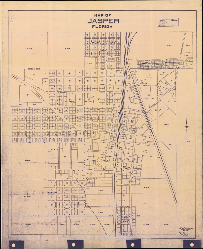
Map of Jasper Florida.
1957 (dated) 27 x 22.5 in (68.58 x 57.15 cm) 1 : 1920
1957 (dated) 27 x 22.5 in (68.58 x 57.15 cm) 1 : 1920
Description
An unrecorded 1924 plat map of Jasper, Florida, originally drawn by Oliver Howard Lang in 1924, then 'traced' by Jay Walton Brown in 1945, and finally printed in diazotype as here in 1957.
As for automobile roads, the designation of the continuation of Hatley St. as the 'Nat'l Highway' suggests that this note was added later by Brown. The national highway referred to was only laid out in 1926, after Lang's survey, and is now U.S. Highway 41. The reference to the old and new 'State Rd. No. 2' reflect the developing designation system following the creation of the State Road Department in 1915.
This map, often referred to as 'Lang's Map of Jasper' appears to have been the first comprehensive plat map undertaken of the town's lands, and is still referred to as a baseline in property disputes, sales, foreclosures, and the like.
A Closer Look
The town of Jasper, seat of Hamilton County near the Georgia border, is displayed, with individual lots numbered and acreage given for larger lots on the outskirts of town. Streets, railroads, public buildings (the courthouse, cemetery, and 'light plant'), and other features are labeled throughout. The rail lines and depot seen here belonged to the Atlantic Coast Line Railroad, one of the great rail networks of the Southeast U.S. at the time.As for automobile roads, the designation of the continuation of Hatley St. as the 'Nat'l Highway' suggests that this note was added later by Brown. The national highway referred to was only laid out in 1926, after Lang's survey, and is now U.S. Highway 41. The reference to the old and new 'State Rd. No. 2' reflect the developing designation system following the creation of the State Road Department in 1915.
This map, often referred to as 'Lang's Map of Jasper' appears to have been the first comprehensive plat map undertaken of the town's lands, and is still referred to as a baseline in property disputes, sales, foreclosures, and the like.
Diazo Print or Whiteprint
The diazo print (whiteprint or diazo for short) is a photo reproductive technique best understood as a reverse cyanotype or blueprint. The process yields distinctive blue lines on white paper. Like cyanotypes, the diazo process gained popularity in architecture circles, where it was a simple and effective way to duplicate documents in the field. The earliest diazotypes appeared around 1880 and were adopted for military and field cartographic use from about 1895. The diazo process was commercialized in 1923, when the German firm, Kalle and Company, developed Ozalid, a patented diazo paper that made diazotyping even easier. By the 1950s, it supplemented cyanotypes as the reprographic technique of choice for technical drawings.Publication History and Census
This map was originally drawn in 1924 by O. H. Lang, the county surveyor of nearby Colquitt County, Georgia. It was then 'traced' by Jay Walton Brown of the State Road Department in 1945, and finally printed in June 1957 by 'W.S.W.' The punch holes on the bottom of the original document suggest that it was bound with similar maps in a larger collection. The present map is not listed among the holdings of any institution, though, as mentioned above, 'Lang's Map of Jasper' is referred to in legal matters and therefore is presumably held by the Hamilton County Clerk's Office or a similar body.CartographerS
Oliver Howard Lang (c. 1887 - 1934), on some documents as Howard O. Lang, was a civil engineer who served as the county surveyor of Colquitt County, Georgia, based in Moultrie. More by this mapmaker...
Jay Walton Brown (c. 1913 - 2004) was a draftsman and civil engineer based in Lake City and Tallahassee, Florida. Born in Meridian, Texas, he went to work for the Florida State Road Department early in his career, then was drafted into military service during World War II, where his cartographic skills were presumably put to good use. After the war, he continued his work at the state Road Department. Learn More...
Condition
Very good. Some printing artifacts on the right and left margins.