This item has been sold, but you can get on the Waitlist to be notified if another example becomes available, or purchase a digital scan.
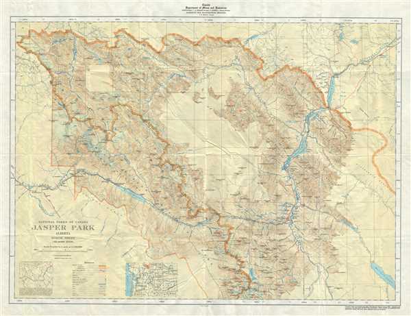
1939 Topographic Map of Jasper Park, Alberta, Canada (Rocky Mountains)
JasperPark-deptmines-1939$100.00

Title
National Parks of Canada Jasper park Alberta North Sheet.
1939 (dated) 23 x 29.5 in (58.42 x 74.93 cm) 1 : 190080
1939 (dated) 23 x 29.5 in (58.42 x 74.93 cm) 1 : 190080
Description
This is a nice example of the 1939 topographical survey chart or map of the beautiful Jasper National Park in Alberta, Canada, part of the Canadian Rockies. The map covers the northern part of the park and its vicinity. Throughout, the map marks railroad lines, roads, trails, marshes, rapids, bridges, forests, glaciers, cliffs, streams, falls, marshes and other topographical features. Cabins, buildings, offices and mines are also noted. Two inset maps are included in the lower left quadrant.
Jasper National Park was originally called Fitzhugh before it was renamed after Jasper Hawes, the operator of the North West Company trading post. The park became a UNSECO World Heritage Site in 1948.
The map was originally compiled, drawn and printed at the office of the Surveyor General, Ottawa in 1934 and was reprinted with corrections in 1939. Issued by the Department of Mines and Resources, Surveys and Engineering Branch.
Condition
Very good. Minor wear and creasing along original fold lines.