This item has been sold, but you can get on the Waitlist to be notified if another example becomes available, or purchase a digital scan.
1718 Chatelain Map of Java
Java-chatelain-1718$1,100.00

Title
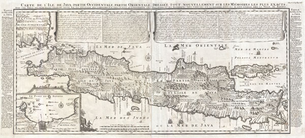
Carte de l'Ile de Java: partie Occidentale, partie Orientale, Dressée tout nouvellement sur les Mémoirs les plus exacts; Avec une Table des principales villes de cette Ile, La situation des comptoirs & autres places qu'y possedent les Hollandois, et des Remarques très curiueuses sur la maniere dont ils se sont établis dans la Ville de Batavia.
1718 (undated) 15.5 x 35 in (39.37 x 88.9 cm)
1718 (undated) 15.5 x 35 in (39.37 x 88.9 cm)
Description
A beautiful example of Henri Chatelain's important 1718 map of Java. Covers the island in full as well as adjacent parts of Sumatra and Bali. Offers beautiful engraving and extraordinary detail throughout, noting rice plantations, mountain ranges, grazing lands, forests, and in many places, elephants and gazelle. The previously unknown southern shore is mapped both correctly and in considerable detail. Also shows some offshore reefs and other dangers. The volcanic island of Krakatau, here identified as Cracatao, which nearly 150 years later would erupt with devastating consequences, appears in the Strait of Sunda between Java and Sumatra. In the lower left quadrant an inset details the city and port of Batavia, then the center of Dutch East Indian Company's activity in the region. Appearing in tapestry style windows at the top of the map is an area of extensive text. Composed by Gueudeville, this is a discussion of the history of the lands and countries depicted. Additional textual data referencing the cities and villages of Java, appears to the left and right of the map proper.
In its day Chatelain's map of Java was by far the most sophisticated study of the island yet published. Previous to this map, the most advanced cartographic rendering of Java was Van der Aa's 1714 mapping of the region, which though it correctly identified general form of Java's northern shore, identified the southern shore as 'Parte Incognita.' Of course the Dutch were active in this region since the 17th century and had no doubt produced accurate manuscript charts of the island, but these were carefully guarded trade secrets controlled by the powerful Vereenigde Oostindische Compagnie (V.O.C. or Dutch East India Company). The publication of Chatelain's map of Java, offered here, suggests that Chatelain somehow obtained his data from a source outside of the V.O.C. That Chatelain's map was copied by Johannes Van Keulen II, the V.O.C.'s own cartographer, nine years later suggests that even the V.O.C., who maintained an active presence on the island, did not possess more accurate data. It is highly likely that Chatelain extracted much of his cartographic information on Java from Hadrien Reland, a Dutch scholar and philologist who composed a number of works on the Indonesian Archipelago in the early 18th century.
A highly important map of the region and a must for an serious collection focusing on the East Indies. Prepared by Henri Chatelain for publication in his monumental seven volume 1718 Atlas Historique.
Cartographer
Henri Abraham Chatelain (1684 - 1743) was a Huguenot pastor of Parisian origins. He lived consecutively in Paris, St. Martins, London (c. 1710), The Hague (c. 1721) and Amsterdam (c. 1728). He is best known as a Dutch cartographer and more specifically for his cartographic contribution in the seminal seven volume Atlas Historique, published in Amsterdam between 1705 and 1720. Innovative for its time, the Atlas Historique combined fine engraving and artwork with scholarly studies of geography, history, ethnology, heraldry, and cosmography. Some scholarship suggests that the Atlas Historique was not exclusively compiled by Henri Chatelain, as is commonly believed, but rather was a family enterprise involving Henri, his father Zacharie and his brother, also Zacharie. More by this mapmaker...
Source
Chatelain, H. A., Atlas Historique, volume V, pate 47, page 128, 1718 edition.
Condition
Very good. Two sheets, joined at center, as issued. Original folds. Blank on verso.
References
National Library of Australia, MAP RM 2008. Koeman, Cornelis, Atlantes Neerlandici. Bibliography of Terrestrial, Maritime and Celestial Atlases and Pilot Books, Published in the Netherlands up to 1880, ch 6 (9). Suarez, T., Early Mapping of Southeast Asia, page 232.