This item has been sold, but you can get on the Waitlist to be notified if another example becomes available, or purchase a digital scan.
1817 Thomas Stamford Raffles Map of Java - first scientific map of Java!
Java-raffles-1817$500.00


Title
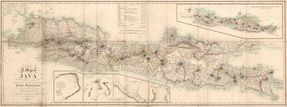
A Map of Java Chiefly from Surveys made during the British Administration Constructed in illustration of an Account of Java By Thomas Stamford Raffles Esquire and Engraved by J. Walker.
1817 (dated) 17 x 44.5 in (43.18 x 113.03 cm) 1 : 800000
1817 (dated) 17 x 44.5 in (43.18 x 113.03 cm) 1 : 800000
Description
A rare 1817 map of Java by Thomas Stamford Raffles, the founder of Singapore. This map is considered to be the first scientifically surveyed map of the island.
A Closer Look
Before Raffles published this piece, maps of Java were mostly confined to coastal outlines, themselves only tenuously understood. By contrast to earlier efforts to map the island, Raffles focused intensely on topography, naming mountains, towns and villages, and ancient ruins. Particularly, the ruins of Prambanan Temple (Brambanan) are identified, both of which were studied extensively during Raffles tenure as Lieutenant-Governor of the East Indies.Inset Maps and Tables
A table of divisions and provinces is situated along the top border and provides the population and area of each. Four inset maps are situated along the bottom border. The first depicts Palabuan Ratu or Wyn Coops Bay, the second and third focus on harbors created by Nusa Kambang'an Island, and the fourth details the Bay of Pachitan. Another inset map, entitled Mineralogical Sketch of the Island of Java, is situated in the upper right corner. Created by Dr. Thomas Horsfield, an American colleague of Raffles, this map details Java's mineralogical 'districts' with short captions on the geological makeup of the island.The 1811 British Invasion of Java
In this map's title, Raffles references the British Administration of Java. Following the 1810 annexation of the Kingdom of Holland to the First French Empire, the British identified Java as a viable target. Troops landed on Java on August 4, 1811, and captured Batavia by the 8th. The defenders, which abandoned the city, fortified themselves in Fort Cornelius, which on August 26, the British besieged and captured. A series of land and amphibious assaults captured all remaining strongholds, and on September 18, the British officially took control of the island. Java's British Period ended in 1814 when the Convention of London returned Java to the Dutch.Publication History and Census
This map was created by Thomas Stamford Raffles and engraved by John Walker for publication in Raffles' 1817 History of Java, though the map is not present in all examples of that work. A History of Java is well represented in institutional collections as it represents the most important history of Java written in the 19th century. The separate map is cataloged as being part of only four institutional collections and is rare on the private market.Cartographer
Sir Thomas Stamford Bingley Raffles (July 5, 1781 - July 5, 1826) was a British statesman best known for founding modern Singapore and British Malaya. Born aboard the ship Ann off Port Morant, Jamaica, Raffles was educated at a boarding school. He began working as a clerk for the British East India Company in London in 1795 at the age of fourteen. He married Olivia Mariamne Devenish, a widow ten years his senior at the age of twenty-three in 1804. The following year he was sent to Prince of Wales Island, Malaya as assistant secretary to the Honourable Philip Dundas, the new Governor of Penang. He soon was sent to Malacca because of his knowledge of the Malay language. Raffles mounted an expedition against Dutch and French Java in 1811, after the French annexation of the Kingdom of Holland during the Napoleonic Wars. After only forty-five days, the British controlled Java, and Raffles was named Lieutenant-Governor of the Dutch East Indies even before the fighting was over. While in control on Java, Raffles led a few military expeditions against Javanese princes, the most significant of which was the assault on Yogyakarta. Raffles also was responsible for the systematic cataloguing of ancient monuments around Java. Also during his time in Java, the first detailed English-language account of Prambanan, a 9th century Hindu temple compound near Yogyakarta, was written by Colin Mackenzie and H.C. Cornelius surveyed Borobudur, a 9th century Mahayana Buddhist temple, and also cleared it of vegetation. It was also during his time on Java that his wife Olivia died, on November 26, 1814. Not long after he death Raffles was removed as Lieutenant-Governor by the East India Company in preparation for Java's return to the Dutch. He returned to England later that year and did not return to the East Indies until 1818. During his time in England, Raffles wrote The History of Java, which was published in 1817 was described the history of the island from ancient times along with its flora, fauna, and geography. Raffles also married his second wife, Sophia Hull, while in England, on February 22, 1817. Upon his return to the East Indies, he became the Lieutenant-Governor of Bencoolen, a relative colonial backwater with pepper as its only major export. During this time Raffles became convinced that the British needed a stronger position in Malaya and began searching for an appropriate location. After several expeditions by him and people on his staff, Raffles settled on the island of Singapura. After much wrangling with the local chiefs, much of the time it was not exactly clear who was in charge, and a challenge from the Dutch who controlled Java and most of Sumatra, Raffles secured treaties to establish the colony that is would become modern-day Singapore. Unfortunately for Raffles, he never got to spend more than eight months at a time in his new, and rapidly-growing, colony, as he was still the Lieutenant-Governor of Bencoolen and was extremely interested in establishing a British presence at Achin on Sumatra. By 1820, Raffles had returned to living at Bencoolen full-time, but suffered the tragic death of three of his children to disease in less than a year. It is unclear how Raffles lost his position in Bencoolen, if he resigned or was replaced, but he, his wife, and only surviving child went to Singapore in 1822 and stayed for eight months, the most time he ever spent there. Raffles and his family left Singapore in February 1824 aboard the East Indiaman Fame, but the ship caught fire and sank. Thankfully, everyone survived, but all of Raffles' papers and drawings were lost. Raffles finally returned home to England in August 1824 in very poor health, and returned to one of his other great talents, botany and zoology. He was one of the founders and the first president of the Zoological Society of London and the London Zoo. Raffles died, at Highwood, his country estate, on July 5, 1826 of apoplexy. More by this mapmaker...
Source
Raffles, T.S., The History of Java, (London) 1817.
Condition
Good. Map exhibits some staining and wear on old fold lines. Laid down on archival tissue. Right margin extended.
References
OCLC 71595298.