This item has been sold, but you can get on the Waitlist to be notified if another example becomes available, or purchase a digital scan.
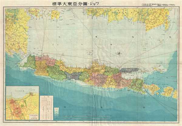
1943 or Showa 18 World War II Era Japanese Map of Java and Bali
Java2-showa18-1943$100.00

Title
Java.
1943 (undated) 21 x 30 in (53.34 x 76.2 cm) 1 : 2000000
1943 (undated) 21 x 30 in (53.34 x 76.2 cm) 1 : 2000000
Description
This is a scarce 1943 Japanese map of Java and surrounding islands, including Bali, Indonesia, issued during World War II. The southern part of Sumatra and Borneo is also included. The map offers superb detail regarding both topographical elements. Notes cities, railways, rivers, shipping lines, etc., and uses shading to display oceanic depths. While Allied World War II maps of this region are fairly common it is extremely rare to come across their Japanese counterparts. An inset map is included in the bottom left quadrant. All text is in Japanese. This map was created as part of the Series of Great East Asia maps prepared by the Japanese during World War II. Represents chart no. 11 in that series.
Condition
Very good. Minor wear along original fold lines and fold intersections. Minor foxing at places. Overall toning. Accompanied by original paper binder.