This item has been sold, but you can get on the Waitlist to be notified if another example becomes available, or purchase a digital scan.
1969 Bollman Bird's Eye View Pictorial Map of Jerusalem, Israel
Jerusalem-bollmann-1969$250.00

Title
Jerusalem.
1969 (dated) 26.75 x 21.75 in (67.945 x 55.245 cm) 1 : 3000
1969 (dated) 26.75 x 21.75 in (67.945 x 55.245 cm) 1 : 3000
Description
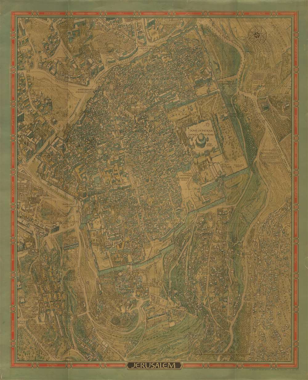
This is a stunning 1969 Herman Bollmann bird's eye view pictorial map of Jerusalem printed with an extraordinary metallic ink. The map depicts the city from Yemin Moshe to the Mount of Offense and from the Rockefeller Museum to Shim'a. Buildings throughout Jerusalem are illustrated in detail, including the Dome of the Rock, the Western Wall, the Al-Aqsa Mosque, the Church of the Redeemer, and the Church of the Holy Sepulcher in the Old City, which is surrounded by its ancient walls. Numerous gates in the walls are identified. Myriad small buildings are illustrated within the Old City, and the Jewish Quarter, Christian Quarter, Muslim Quarter, and Armenian Quarter are each labeled. Buildings and other sites outside the Old City are also illustrated and labeled, including the Church of the Tomb of the Virgin, Gethsemane, David's Tomb, the Church of Dormition, and the Yemin Moshe Synagogue. The Catholic, Prostestant, Jewish, and Muslim cemeteries are all identified. Numerous streets are identified. The whole is surrounded by a border bearing the name of Jerusalem translated into sixteen different languages.
Publication History and Census
This map was published in many different editions and states, all of which were created by Herman Bollman, who was commissioned by Wim van Leer. The present example was published in Haifa, Israel, by Wim van Leer in 1969, with unforgettable metallic ink. Editions of this same vertically oriented map printed with more conventional ink were also produced. A larger horizontally oriented piece was also created and encompasses more of the city. Every edition bears the same copyright information, indicating that they were created and published simultaneously. We are aware of examples of each of these editions, which vary in rarity. The present example is the only known example of the map featuring this metallic printing process.CartographerS
Herman Bollmann (1911 - 1971) was a German cartographer and map maker active from roughly 1940 to 1970. Before World War II, Bollmann was a well-known woodcarver and engraver based in Braunschweig, Germany. Following the war, Bollmann developed a reputation as a printer of unique three-dimensional maps. Working over a period of 25 years, Bollmann established a reputation as an artistic cartographer, producing over 39 unique projections of various cities in Europe and America. Bollmann revived the 19th-century cartographic technique known as Vogelschaukarten, a way of making three-dimensional axonometric projections. Bollmann and his team relied heavily on aerial cartography to compose distinctive cartographic masterpieces that are coveted by collectors all over the world. More by this mapmaker...
Wim van Leer (1913 - April 14, 1992) was a Dutch-Israeli industrialist and philanthropist. Van Leer served in Britain's Royal Air Force during World War II as a pilot and, after immigrating to Israel, served in the Israeli Air Force as well. He was best known for establishing Israel's first film archive, the Jerusalem Cinematheque. The Van Leer Institute was endowed by his family and promotes Arabe-Jewish dialogue. Van Leer married Lia Greenberg (August 8, 1924 - March 13, 2015) in Haifa in 1952. Learn More...
Condition
Very good. Wear along margins. Blank on verso.