This item has been sold, but you can get on the Waitlist to be notified if another example becomes available, or purchase a digital scan.
1572 Braun and Hogenberg Map of Jerusalem
Jerusalem-braun-1572$450.00

Title
Hierosolyma, Clarrisima Totius Orientis Civitas ludaee Metropolis…
1572 (undated) 14 x 19.5 in (35.56 x 49.53 cm)
1572 (undated) 14 x 19.5 in (35.56 x 49.53 cm)
Description
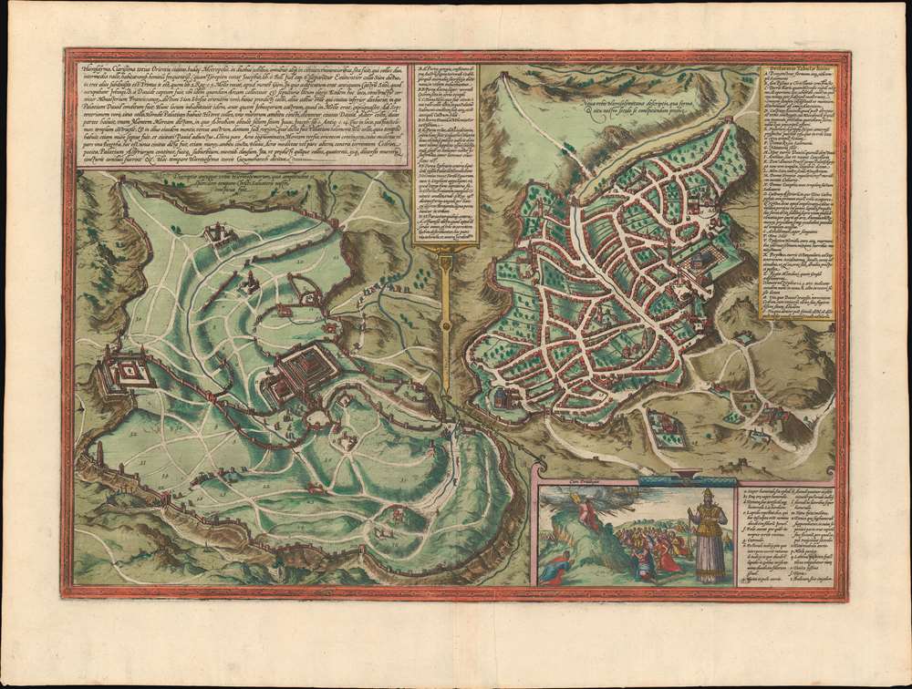
This is a 1572 Georg Braun and Frans Hogenberg double-view of Jerusalem depicts Biblical Jerusalem and the modern city during the 16th century. Biblical Jerusalem appears on the left 'in its full splendor'. In the lower left, the procession of Jesus to Golgotha is illustrated and Judas is shown hanging from a tree outside the city walls not far from this procession. The Temple Mount, in all its glory, dominates the center of the view of the ancient city and numerous other monuments are included as well. The city's vast system of fortifications is also illustrated and each of the city's many gates are identified by pairs of capital letters which correspond to a key in the upper right corner.
A view of Jerusalem as it was in the late 16th century, when Braun and Hogenberg created this stunning piece, is situated on the right side of the sheet. Monuments and other locations throughout the city are labeled using both capital and lower-case letters that correspond with a table located on the right side of the view. Some of these monuments are illustrated in both views, creating a connection between the ancient city and its modern iteration. A brilliant concept, this allows the viewer to feel as if they can almost touch Biblical Jerusalem, both by being in possession of the map itself, and by visiting the sites that survived the centuries and still stood in Jerusalem at that point in history. An inset situated in the lower right corner illustrated Moses receiving the Ten Commandments on Mt. Sinai. Aaron is also illustrated in the inset dressed in extravagant garments and other accoutrements. A table next to Aaron identifies all the garments and other objects worn or held by Aaron.
This double-view was drawn by Georg Braun and Frans Hogenberg and published in their Civitates Orbis Terrarum, the most famous and influential 16th century book of town plans.
CartographerS
Georg Braun (1541 – March 10, 1622) was a German deacon, viewmaker, and typo-geographer based in Cologne. Along with Franz Hogenberg (1535 - 1590), Braun is best known for his publication of the highly influential city atlas Civitates Orbis Terrarum. The six volume work, with some 546 views, was published between 1572 and 1617 and intended a companion to Abraham Ortelius' Theatrum Orbis Terrarum - thus certain obvious stylistic similarities. In compiling the Civitates Braun took on the role of editor while most of the engraving work was completed by Franz Hogenberg. Braun died, as he was born, in Cologne. More by this mapmaker...
Franz Hogenberg (1535 - 1590), often called 'Master Franz,' was a Flemish engraver active in the late 16th century. Hogenberg was born in Mechelen, the son of Nicolas Hogenberg, where he trained under the cartographer H. Terbruggen. He later relocated to Antwerp where he achieved success as an engraver, working with Abraham Ortelius, Hieronymus Cock, and others. In 1568, his name appeared on the list of those banned from the Netherlands by the Duke of Alva, forcing his family to flee to London. There he engraved for Christopher Saxon's Atlas of England and Wales. By 1570 he emigrated to Germany settling in Cologne. In Cologne he married his second wife, Agnes Lomar, with whom he had six children. In 1579 the couple were briefly imprisoned for holding illicit secret religious meetings, but were released in short order. Along with German cleric George Braun (1541 – March 10, 1622), Hogenberg issued the highly influential city atlas Civitates Orbis Terrarum. The six volume work, with some 546 views, was published between 1572 and 1617 and intended a companion to Abraham Ortelius' Thatrum Orbis Terrarum - thus certain obvious stylistic similarities. In compiling the Civitates Hogenberg took on the role of engraver while most of the editing was left to Georg Braun. Hogenberg died in Cologne, Germany, before the Civitates was completed. After his death, Hogenberg's work was continued by his son, Abraham Hogenberg, who, under the direction of Agnes, his mother, took over his father's enterprise at just 20. Learn More...
Source
Braun, G. and Hogenberg, F. Civitatus Orbis Terrarum, 1572.
The Civitatus Orbis Terrarum is an 6-volume atlas of cities, or town book, compiled and written by George Braun, Canon of Cologne Cathedral and Franz Hogenberg. Braun and Hogenberg gathered together vast amounts of information and draft plans to produce over 500 city views/maps published in six parts between 1572 and 1617. Most of the town views and plans were engraved by Simon van den Neuvel (Novellanus) and Frans Hogenberg, many after drawings by Joris Hoefnagel. The Civitatus Orbis Terrarum was printed in Cologne, but in the Flemish style after Abraham Ortelius, the preeminent cartographer of the period. The text throughout is the work of Braun. The work proved to be a great success, reflecting the period's greater fascination with notable metropolises than with national boundaries. After the initial publication of volume 1, the popularity of the led to a second volume. In the introduction to volume 2, Braun requests that those who live in cities not represented, sent details of their own metropolises. This led to the publication of volumes 3, 4, and 5. Volume 6, the last, did not appear until 1617 under Franz Hogenberg's son, Abraham Hogenberg. The volumes include
- Civitates orbis terrarium, first edition 1572.
- De praecipuis, totius universi urbibus, liber secundus, first edition 1575.
- Urbium praecipuarum totius mundi, liber tertius, first edition 1581.
- Urbium praecipuarum totius mundi, liber quartus, first edition 1588.
- Urbium praecipuarum mundi theatrum quintum, first edition 1596.
- Theatri praecipuarum totius mundi urbium liber sextus, first edition 1617.
Condition
Very good. Even overall toning. Verso repair to centerfold separation. Text in Latin. Latin text on verso.
References
Laor 1039. OCLC 234165769.