1581 / 1597 Bunting City Plan of Jerusalem
Jerusalem-bunting-1581-2$650.00

Title
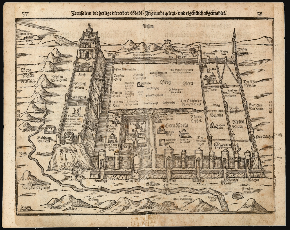
Jerusalem die heilige viereckete Stadt, in grund gelegt und eigentlich abgemahlet.
1581 (undated) 11 x 14.25 in (27.94 x 36.195 cm)
1581 (undated) 11 x 14.25 in (27.94 x 36.195 cm)
Description
This is Heinrich Bünting's 1581 bird's-eye view of the Holy City of Jerusalem. Despite its schematic appearance, the plan was presented to Bünting's readers as depicting the city as being drawn as it was actually laid out - 'in Grundt gelegt und eigentlich abgemahlet'. This fascinating view appeared in Bünting's Itinerarium Sacrae, the first and for many years the only complete work of biblical geography. As such, this map's representation of Jerusalem would be for many years the armchair pilgrim's best view of the Holy City.
A Closer Look
The city is presented as if in a bird's-eye view, oriented to the west (the cardinal directions are given at each side of the woodcut.) Bünting's work is derived from Biblical descriptions, and the reports of 1st-century Roman historian Flavius Josephus: for example, the depiction of the city as a square comes from Josephus' description of Jerusalem as 'four-square.' Within that framework, Biblical landmarks are placed within the city such as the Temple of Solomon, the palace of King David on Mount Sion, Herod's palace, and so forth. In the distance, the town of Bethlehem can be seen and is named. Directly to the west of Jerusalem, Golgotha and its crosses is shown.Publication History and Census
This map first appeared in Bünting's Itinerarium in 1581, and appeared in the work's many editions for the rest of the century. According to Laor, the block was used without change in its editions up to 1600, but with variations in the letterpress pagination. The present example conforms typographically to the 1597 Magdeburg edition.Cartographer
Heinrich Bünting (1545 – 1606) was a Protestant pastor and theologian. He was born in Hanover, and studied theologian Witemberg. He is best known for his book of woodcut maps titled Itinerarium Sacrae Scripturae (Travel book through Holy Scripture) first published in 1581. It was the first complete summary of biblical geography available. More by this mapmaker...
Source
Bünting, Heinrich, Itinerarium Sacrae Scripturae, (Magdeburg) 1597.
Condition
Good. Mends to margin and centerfold; cropped to left and right with some loss to borders. Margins reinstated.
References
OCLC 234164725. Laor, E., Mapping of the Holy Land, #968B.