This item has been sold, but you can get on the Waitlist to be notified if another example becomes available.
1964 Habesch The Commercial Press Pictorial City Plan or Map of Jerusalem
Jerusalem-commercialpress-1964$200.00


Title
Jerusalem.
1964 (dated) 17 x 21.5 in (43.18 x 54.61 cm)
1964 (dated) 17 x 21.5 in (43.18 x 54.61 cm)
Description
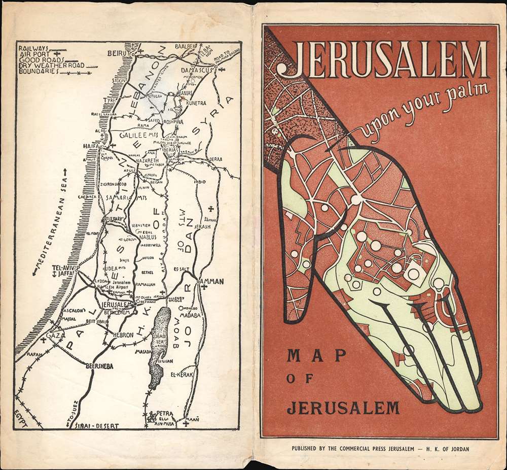
This is a c. 1964 Tewfic Habesch pictorial city plan or map of Jerusalem. Buildings throughout the city are illustrated and labeled, including cinemas, hospitals, schools, and police stations. Other buildings, including the Bezalel Institute Museum, the Kind David Hotel, the Dome of the Rock, and Dormition Church, are labeled and illustrated with a small circular view. Color is used to differentiate between the Old City and newly constructed areas as well as between public buildings and those with historical or religious significance.
Later, during the meetings in Rhodes to hammer out the 1949 Armistice Agreements, the map drawn by the commanders was found to be the only official document indicating the line dividing Jerusalem agreed upon by both parties. Thus, the informality and the inaccuracies went from being a ceasefire to a binding international border. This meant that neighborhoods, streets, and even houses became contentious international disputes, as the line drawn was rough at best. The border was fortified, with military positions springing up all along the wall. Included in this agreement was an Israeli-controlled area on Mt. Scopus, which is encircled here by the same red line that bisects the city (and labeled as United Nations Controlled Territory). A bi-weekly convoy to the Israeli enclave on Mt. Scopus crossed the border between the two states through the Mandelbaum Gate, which is labeled here.
Illustrating Jerusalem's Pre-1967 Borders - The Green Line
Known as 'The Green Line', red overprinting highlights territorial divisions within Jerusalem after the 1948 Arab-Israeli War and the 1967 Six-Day War, when Israel seized East Jerusalem, the West Bank, Gaza Strip, and Golan Heights. The left (or west) side of the map is labeled as 'Jewish Controlled Territory', while the right (or east) side of the map is 'Arab Territory'. These two zones are separated by a 'No Man's Land' that winds its way through Jerusalem around important sites, including the Old City (which fell on the Arab side of the line) and Dormition Church (which fell on the Jewish side). Two enclaves were controlled by the United Nations, which are circled in red.'The Green Line'
The 'Green Line' agreement was never meant to signify permanent international borders, only a temporary demarcation line between Israel and Jordan following the 1948 Arab-Israeli War. The 'Green Line' even extended through Jerusalem, dividing the city into East Jerusalem, which was part of the Kingdom of Jordan, and West Jerusalem, the capital of the newly-created State of Israel. When the ceasefire was finally declared, an Israeli and Jordanian commander met in an abandoned house to outline the boundaries of the ceasefire. The Israeli commander used a green wax pencil to outline Israeli-controlled positions, while the Jordanian commander used a red pencil to outline positions under Jordanian control, with the area between the two lines becoming a No Man's Land. Neither commander believed that this informally arrived at agreement represented anything more than a temporary ceasefire line, meaning that little notice was given to inaccuracies and errors in their work due to the thickness of the pencils, deviations in the drawings, or segments of discontinuous lines.Later, during the meetings in Rhodes to hammer out the 1949 Armistice Agreements, the map drawn by the commanders was found to be the only official document indicating the line dividing Jerusalem agreed upon by both parties. Thus, the informality and the inaccuracies went from being a ceasefire to a binding international border. This meant that neighborhoods, streets, and even houses became contentious international disputes, as the line drawn was rough at best. The border was fortified, with military positions springing up all along the wall. Included in this agreement was an Israeli-controlled area on Mt. Scopus, which is encircled here by the same red line that bisects the city (and labeled as United Nations Controlled Territory). A bi-weekly convoy to the Israeli enclave on Mt. Scopus crossed the border between the two states through the Mandelbaum Gate, which is labeled here.
Dating the Map
While a date of 1952 is printed on the map, the Hotel Jerusalem Intercontinental, which opened on the Mount of Olives in 1964, is labeled along the right border. Built by the Jordanian government, the hotel was managed by the U.S. Intercontinental Hotels. It was renamed Hotel Inter-Continental Jerusalem in 1966, suggesting that this map must have been printed in that two-year span. After the Six-Day War, the Jordanians lost sovereignty over Jerusalem and the hotel was entrusted to the Custodian of Absentee Property. Today, the hotel is known as the Seven Arches Hotel (because Inter-Continental did not renew its management agreement in 1989).Publication History and Census
This map was created and published by The Commercial Press in 1952. However, the present example must date from a later printing due to the presence of the Hotel Jerusalem Intercontinental. At least three editions of this map were published. The first, published around 1942, bears the artist's name, F.T. Treitel. The second edition, published in 1952, does not include Treitel's name. This example represents the third, undated edition. Nine examples of the 1952 edition are cataloged in OCLC and are part of the institutional collections at Princeton University, the Osher Map Library at the University of Southern Maine, Western Illinois University, the University of Miami, the University of Minnesota Minneapolis, the University of Colorado Boulder, the University of California Davis, the University of Zurich, and the National Library of Israel.Cartographer
Habesch Commercial Press Ltd (1920 - 2020) was a Palestinian publishing house active in Jerusalem for most of the 20th and the early 21st centuries. Founded by Tewfic Habesch in 1920, The Commercial Press became an important publishing house in Jerusalem. They published books, maps, and other materials. Tewfic Issa Habesch, the founder's grandson, was forced to close the business in 2020 - citing imitates put on Palestinian business by the Israeli state. More by this mapmaker...
Condition
This is a c. 1964 Habesch Commercial Press pictorial city plan or map of Jerusalem. Buildings throughout the city are illustrated and labeled, including cinemas, hospitals, schools, and police stations. Other buildings, including the Bezalel Institute Museum, the Kind David Hotel, the Dome of the Rock, and Dormition Church, are labeled and illustrated with a small circular view. Color is used to differentiate between the Old City and newly constructed areas as well as between public buildings and those with historical or religious significance.
Later, during the meetings in Rhodes to hammer out the 1949 Armistice Agreements, the map drawn by the commanders was found to be the only official document indicating the line dividing Jerusalem agreed upon by both parties. Thus, the informality and the inaccuracies went from being a ceasefire to a binding international border. This meant that neighborhoods, streets, and even houses became contentious international disputes, as the line drawn was rough at best. The border was fortified, with military positions springing up all along the wall. Included in this agreement was an Israeli-controlled area on Mt. Scopus, which is encircled here by the same red line that bisects the city (and labeled as United Nations Controlled Territory). A bi-weekly convoy to the Israeli enclave on Mt. Scopus crossed the border between the two states through the Mandelbaum Gate, which is labeled here.
Illustrating Jerusalem's Pre-1967 Borders - The Green Line
Known as 'The Green Line', red overprinting highlights territorial divisions within Jerusalem after the 1948 Arab-Israeli War and the 1967 Six-Day War, when Israel seized East Jerusalem, the West Bank, Gaza Strip, and Golan Heights. The left (or west) side of the map is labeled as 'Jewish Controlled Territory', while the right (or east) side of the map is 'Arab Territory'. These two zones are separated by a 'No Man's Land' that winds its way through Jerusalem around important sites, including the Old City (which fell on the Arab side of the line) and Dormition Church (which fell on the Jewish side). Two enclaves were controlled by the United Nations, which are circled in red.'The Green Line'
The 'Green Line' agreement was never meant to signify permanent international borders, only a temporary demarcation line between Israel and Jordan following the 1948 Arab-Israeli War. The 'Green Line' even extended through Jerusalem, dividing the city into East Jerusalem, which was part of the Kingdom of Jordan, and West Jerusalem, the capital of the newly-created State of Israel. When the ceasefire was finally declared, an Israeli and Jordanian commander met in an abandoned house to outline the boundaries of the ceasefire. The Israeli commander used a green wax pencil to outline Israeli-controlled positions, while the Jordanian commander used a red pencil to outline positions under Jordanian control, with the area between the two lines becoming a No Man's Land. Neither commander believed that this informally arrived at agreement represented anything more than a temporary ceasefire line, meaning that little notice was given to inaccuracies and errors in their work due to the thickness of the pencils, deviations in the drawings, or segments of discontinuous lines.Later, during the meetings in Rhodes to hammer out the 1949 Armistice Agreements, the map drawn by the commanders was found to be the only official document indicating the line dividing Jerusalem agreed upon by both parties. Thus, the informality and the inaccuracies went from being a ceasefire to a binding international border. This meant that neighborhoods, streets, and even houses became contentious international disputes, as the line drawn was rough at best. The border was fortified, with military positions springing up all along the wall. Included in this agreement was an Israeli-controlled area on Mt. Scopus, which is encircled here by the same red line that bisects the city (and labeled as United Nations Controlled Territory). A bi-weekly convoy to the Israeli enclave on Mt. Scopus crossed the border between the two states through the Mandelbaum Gate, which is labeled here.
Dating the Map
While a date of 1952 is printed on the map, the Hotel Jerusalem Intercontinental, which opened on the Mount of Olives in 1964, is labeled along the right border. Built by the Jordanian government, the hotel was managed by the U.S. Intercontinental Hotels. It was renamed Hotel Inter-Continental Jerusalem in 1966, suggesting that this map must have been printed in that two-year span. After the Six-Day War, the Jordanians lost sovereignty over Jerusalem and the hotel was entrusted to the Custodian of Absentee Property. Today, the hotel is known as the Seven Arches Hotel (because Inter-Continental did not renew its management agreement in 1989).Publication History and Census
This map was created and published by The Habesch Commercial Press in 1952. However, the present example must date from a later printing due to the presence of the Hotel Jerusalem Intercontinental. At least three editions of this map were published. The first, published around 1942, bears the artist's name, F. T. Treitel. The second edition, published in 1952, does not include Treitel's name. This example represents the third, undated edition. Nine examples of the 1952 edition are cataloged in OCLC and are part of the institutional collections at Princeton University, the Osher Map Library at the University of Southern Maine, Western Illinois University, the University of Miami, the University of Minnesota Minneapolis, the University of Colorado Boulder, the University of California Davis, the University of Zurich, and the National Library of Israel.References
OCLC 68784361.