This item has been sold, but you can get on the Waitlist to be notified if another example becomes available, or purchase a digital scan.
1905 Walker View of the Joy Line: Boston, Cape Cod, New York
JoyLineView-walker-1905$187.50

Title
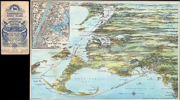
Birds eye view of Massachusetts, Rhode Island and Connecticut. A comprehensive map of the waterways traversed by steamers of the Joy Line between Boston-New York, Providence, with table of distances.
1905 (dated) 14 x 21 in (35.56 x 53.34 cm)
1905 (dated) 14 x 21 in (35.56 x 53.34 cm)
Description
This unusual 1905 chromolithograph bird's-eye view of Cape Cod, New York, and Long Island, was issued by George H. Walker to promote the Joy Line. The Joy Line was a regular steamship ferry services connecting Boston, Massachusetts; Providence, Rhode Island; and New York, New York. The view looks westward from a position high above Massachusetts Bay, with New York City and Long Island appearing in the distance. Cape Code looms prominently in the foreground with Martha's Vineyard and Nantucket just to the south. Block island is shows, both two lights. On Long Island the Montauk and Greenport are noted. Along the Connecticut coast, Stonington, New London, New Haven, and Bridgeport are all noted. In the distance the Statues of Liberty and New York City are visible. The Joy Line Dock, pier 35, is noted in red, as is the route of the Joy line through the Long Island Sound, Vineyard Sound, and around Cape Cod, to Boston.
In the upper left, there is a detail map of New York City, including Manhattan, the Bronx, Queens, and Brooklyn. There too the route of the Joy Line appears in Red. Pier 35 is identified just under the Brooklyn Bridge.
Walker issued a number of views of the Boston area, but this view, with its peculiar orientation, is unusual. It is also quite rare. We are aware of only two other examples of this map, one in the archives at the Library of Congress, and another at in the Osher Map Library.
Cartographer
George Hiram Walker (January 4, 1852 - November 14, 1927) was a Boston based publisher of books, views, and maps active in the late 19th and early 20th centuries. Born in Springfield, Vermont, Walker started his life as a dry goods merchant but developed an active interest in publishing during the early 1870s. Walker began publishing in 1878 when he partnered with an unknown New York Firm. Two years later, Walker brought the operation in house by partnering with his brother, Oscar W. Walker, in the opening of a lithography studio at 81 Milk Street, Boston. Shortly thereafter the firm expanded to new offices at 160 Tremont Street, Boston. The Walker brothers produced a large corpus of works, most of which focused on travel and tourism in New England. Walker also established the Walker-Gordon Milk Laboratory with Dr. Thomas Morgan Rotch and Gustave Gordon. This interesting investment was based on the premise that infant deaths could be avoided by providing higher quality milk. The company eventually became a great success, producing a high-quality cow milk that closely resembled human breast milk. In the process the Walker-Gordon laboratory developed many of the dairy health standards that are still with us today. Walker married Irene L. Loud on March 25, 1885. More by this mapmaker...
Condition
Very good. Accompanies original binder, from which it has been separated.
References
OCLC 694908889.