This item has been sold, but you can get on the Waitlist to be notified if another example becomes available, or purchase a digital scan.
1715 Homann Map of the Holy Land / Israel / Palestine
Judaea-homann-1715$375.00

Title
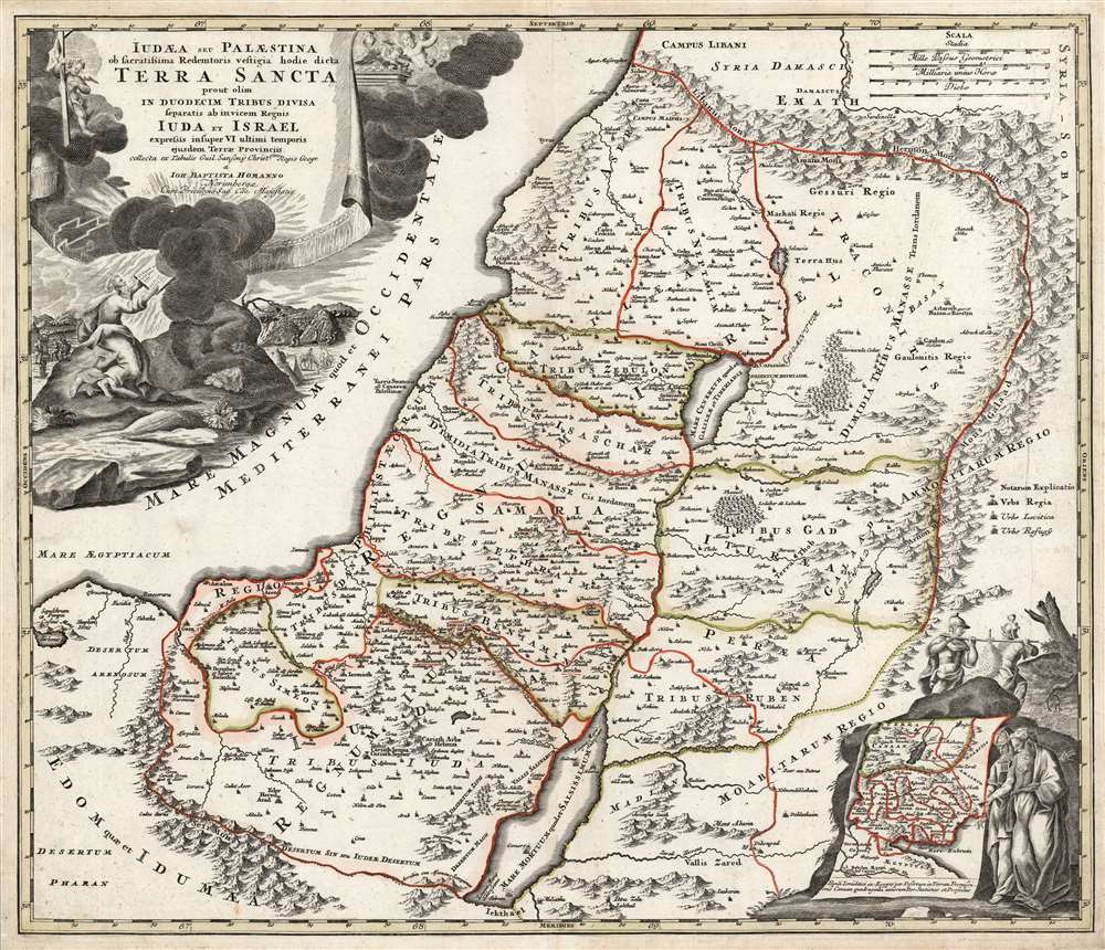
Judæa seu Palæstina ob sacratissima Redemtoris vestigia hodie dicta Terra Sancta prout olim in duodecim tribus divisa, seperatis ab invicem Regnis Iuda et Israel expressis in super VI. ultimi temporis ejusdem Terræ Provinciis.
1715 (undated) 19.25 x 22.5 in (48.895 x 57.15 cm) 1 : 770000
1715 (undated) 19.25 x 22.5 in (48.895 x 57.15 cm) 1 : 770000
Description
This is a beautiful example of J. B. Homann's 1707 map of the Holy Land. As Homann noted in the map's title, it is derived from the work of the French mapmaker Guillaume Sanson (1633 - 1703). The map combines modern geographical information with place names drawn from Biblical history: specifically, the Exodus, and the settlement of the Twelve Tribes of Israel. It depicts the Mediterranean coast from Sidon (in modern-day Lebanon) to Alexandria (not named, but marked with Pompey's Pillar). The territories of the Tribes of Israel are marked, appearing on both sides of the Jordan. Mountains and forest regions are illustrated pictorially. Intriguingly, the Dead Sea contains the ruins of Sodom, Gomorrah, Adama, and Seboim - all destroyed for their sins.
The Vignettes
The map is superbly engraved, with Biblical vignettes both in the title cartouche and in the lower right. The title cartouche is flanked with putti, several of whom are fluttering about the Ark of the Covenant, half-obscured by clouds. At the base of the cartouche, Moses receives the Ten Commandments from the burning bush - meanwhile, in the background, Israelites worship the Golden Calf. In the lower right is an inset map showing the path of the Israelites from Egypt to Canaan. Moses and Aaron consult the map. In the background, two of the dozen spies sent by Moses march by with a massive bunch of grapes set on their shoulders; judging by their positive, 'can-do' expressions, it would seem that these represent Joshua and Caleb.Publication History and Census
This map was produced by Homann for inclusion in his Neuer Atlas as early as 1707. In 1715, Homann received an Imperial privilege for his Grosser Atlas, after which the privilege was added. This example, with the privilege, dates as early as 1715 but probably no later than the 1730s, as it still bears Homann's imprint and not that of his heirs. Homann's atlases are well represented in institutional collections. We see fifteen examples of this map cataloged in OCLC without the privilege; only two examples are noted with the privilege, and these are held at the Danish National Bibliotheque and the Royal Danish Library.CartographerS
Johann Baptist Homann (March 20, 1664 - July 1, 1724) was the most prominent and prolific map publisher of the 18th century. Homann was born in Oberkammlach, a small town near Kammlach, Bavaria, Germany. As a young man, Homann studied in a Jesuit school and nursed ambitions of becoming a Dominican priest. Nonetheless, he converted to Protestantism in 1687, when he was 23. It is not clear where he mastered engraving, but we believe it may have been in Amsterdam. Homann's earliest work we have identified is about 1689, and already exhibits a high degree of mastery. Around 1691, Homann moved to Nuremberg and registered as a notary. By this time, he was already making maps, and very good ones at that. He produced a map of the environs of Nürnberg in 1691/92, which suggests he was already a master engraver. Around 1693, Homann briefly relocated to Vienna, where he lived and studied printing and copper plate engraving until 1695. Until 1702, he worked in Nuremberg in the map trade under Jacob von Sandrart (1630 - 1708) and then David Funck (1642 - 1709). Afterward, he returned to Nuremberg, where, in 1702, he founded the commercial publishing firm that would bear his name. In the next five years, Homann produced hundreds of maps and developed a distinctive style characterized by heavy, detailed engraving, elaborate allegorical cartouche work, and vivid hand color. Due to the lower cost of printing in Germany, the Homann firm could undercut the dominant French and Dutch publishing houses while matching their diversity and quality. Despite copious output, Homann did not release his first major atlas until the 33-map Neuer Atlas of 1707, followed by a 60-map edition of 1710. By 1715, Homann's rising star caught the attention of the Holy Roman Emperor Charles VI, who appointed him Imperial Cartographer. In the same year, he was also appointed a member of the Royal Academy of Sciences in Berlin. Homann's prestigious title came with several significant advantages, including access to the most up-to-date cartographic information as well as the 'Privilege'. The Privilege was a type of early copyright offered to very few by the Holy Roman Emperor. Though less sophisticated than modern copyright legislation, the Privilege offered limited protection for several years. Most all J. B. Homann maps printed between 1715 and 1730 bear the inscription 'Cum Priviligio' or some variation. Following Homann's death in 1724, the firm's map plates and management passed to his son, Johann Christoph Homann (1703 - 1730). J. C. Homann, perhaps realizing that he would not long survive his father, stipulated in his will that the company would be inherited by his two head managers, Johann Georg Ebersberger (1695 - 1760) and Johann Michael Franz (1700 - 1761), and that it would publish only under the name 'Homann Heirs'. This designation, in various forms (Homannsche Heirs, Heritiers de Homann, Lat Homannianos Herod, Homannschen Erben, etc.) appears on maps from about 1731 onwards. The firm continued to publish maps in ever-diminishing quantities until the death of its last owner, Christoph Franz Fembo (1781 - 1848). More by this mapmaker...
Nicolas Sanson (December 20, 1600 - July 7, 1667) and his descendants were the most influential French cartographers of the 17th century and laid the groundwork for the Golden Age of French Cartography. Sanson was born in Picardy, but his family was of Scottish Descent. He studied with the Jesuit Fathers at Amiens. Sanson started his career as a historian where, it is said, he turned to cartography as a way to illustrate his historical studies. In the course of his research some of his fine maps came to the attention of King Louis XIII who, admiring the quality of his work, appointed Sanson Geographe Ordinaire du Roi. Sanson's duties in this coveted position included advising the king on matters of geography and compiling the royal cartographic archive. In 1644, he partnered with Pierre Mariette, an established print dealer and engraver, whose business savvy and ready capital enabled Sanson to publish an enormous quantity of maps. Sanson's corpus of some three hundred maps initiated the golden age of French mapmaking and he is considered the 'Father of French Cartography.' His work is distinguished as being the first of the 'Positivist Cartographers,' a primarily French school of cartography that valued scientific observation over historical cartographic conventions. The practice result of the is less embellishment of geographical imagery, as was common in the Dutch Golden Age maps of the 16th century, in favor of conventionalized cartographic representational modes. Sanson is most admired for his construction of the magnificent atlas Cartes Generales de Toutes les Parties du Monde. Sanson's maps of North America, Amerique Septentrionale (1650), Le Nouveau Mexique et La Floride (1656), and La Canada ou Nouvelle France (1656) are exceptionally notable for their important contributions to the cartographic perceptions of the New World. Both maps utilize the discoveries of important French missionaries and are among the first published maps to show the Great Lakes in recognizable form. Sanson was also an active proponent of the insular California theory, wherein it was speculated that California was an island rather than a peninsula. After his death, Sanson's maps were frequently republished, without updates, by his sons, Guillaume (1633 - 1703) and Adrien Sanson (1639 - 1718). Even so, Sanson's true cartographic legacy as a 'positivist geographer' was carried on by others, including Alexis-Hubert Jaillot, Guillaume De L'Isle, Gilles Robert de Vaugondy, and Pierre Duval. Learn More...
Source
Homann, J. B., Neuer Atlas bestehend in einig curieusen Astronomischen Kuppren und vielen auserlesenen accuratensten Land-Charten über die Gantze Welt, (Nuremberg: Homann), 1716.
Homann's Neuer Atlas bestehend in einig curieusen Astronomischen Kuppren und vielen auserlesenen accuratensten Land-Charten über die Gantze Welt was first publihsed in 1707 with 33 maps. A second edition followed in 1710 with 60 maps. Subsequent editions followed until about 1730. The title page notes proudly that the atlas features measurements based on the 'Copernican principle of the moving sky', a truly state-of-the-art innovation for the period. Regardless of editions, collations of the atlas are inconsistent, with some examples having less, while others have more maps - a consequence of the fact that the map sheets were delivered loose, to be bound at the buyer's discretion, and so some buyers chose to omit maps they did not consider relevant, or add others they did. Between editions, the constituent maps, particularly of European regions, were regularly updated to reflect the most recent political events. The atlas continued to be published by Homann's son, J. C. Homann (1703 - 1730), and then by Homann Heirs. Most examples also feature a fine allegorical frontispiece with the title Atlas Novus Terrarum Orbis Imperia, regna et Status, which was used for multiple Homann atlases, including the Neuer Atlas and the Atlas Minor.
Condition
Very good. Printer's crease at right, exhibiting no loss. Bold impression with original outline color.
References
Rumsey 12499.064. OCLC 874773263. Laor, E., Maps of the Holy Land: Cartobibliography of Printed Maps, 1475 - 1900, 340.